|
WXAJ(FM)
Call Sign History
WXAJ from 11/29/1991
891228MG from ???
|
99.7 MHz
|
Hillsboro, IL
|
|
WXAJ Channel: 259B 99.7 MHz
Hillsboro, Illinois
Service: FM - A full-service FM station or application.
Facility ID: 4738
FRN: 0002592830
Fac. Service: FM
Status: LIC (Licensed And Reduced Power)
73.215 Station
Application Accepted: 08/06/1999
Application Granted: 03/31/2000
File Number: BLH-19990806KC
License Expires: 12/01/2028
Prefix Type: This is a license for a commercial FM station
Application Type: License To Cover
FCC Website Links:
LMS Facility Details
This Application
Other WXAJ Applications
Including Superseded Applications
Service Contour - Open Street Map or USGS Map (54 dBu)
Service Contour - KML / Google Earth (54 dBu)
Public Inspection Files
Facility Type: FM STATION
Class: B, A Zone I or I-A station; with 25kW-50kW ERP and a class contour distance 39km-52km
Site Location: 39-21-12.2 N 89-31-53.3 W (NAD 83)
Site Location: 39-21-12.0 N 89-31-53.0 W (Converted to NAD 27)
Effective Radiated Power: 50 kW
Transmitter Output Power: 17.5 kW
Antenna Center HAAT: 150 m (492 ft.)
Antenna Center AMSL: 341 m (1119 ft.)
Antenna Center HAG: 149 m (489 ft.)
Site Elevation: 192 m. (630 ft.)
Height Overall*: 155 m (509 ft.)
(* As Filed In This Application, may differ from ASR Data, Below.)
Directional Antenna
Antenna Make/Model: Electronics Research Inc. LP-8C-DA-HW-SP, 8- BAY, CIRCULARLY POLARIZED
Antenna ID: 28366
Polarization:
|
Antenna Data for Antenna Id: 28366
WXAJ FM File: BLH-19990806KC
Electronics Research Inc. - LP-8C-DA-HW-SP, 8- BAY, CIRCULARLY POLARIZED
Service: FM
|
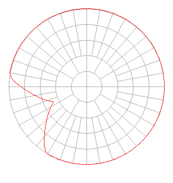 |
| Azimuth | Ratio | Azimuth | Ratio | Azimuth | Ratio | Azimuth | Ratio |
| 0 | 1.000 | 10 | 1.000 | 20 | 1.000 | 30 | 1.000 |
| 40 | 1.000 | 50 | 1.000 | 60 | 1.000 | 70 | 1.000 |
| 80 | 1.000 | 90 | 1.000 | 100 | 1.000 | 110 | 1.000 |
| 120 | 1.000 | 130 | 1.000 | 140 | 1.000 | 150 | 1.000 |
| 160 | 1.000 | 170 | 1.000 | 180 | 1.000 | 190 | 1.000 |
| 200 | 1.000 | 210 | 1.000 | 215 | 0.944 | 220 | 0.841 |
| 225 | 0.750 | 230 | 0.668 | 235 | 0.596 | 240 | 0.531 |
| 245 | 0.473 | 250 | 0.531 | 255 | 0.596 | 260 | 0.668 |
| 265 | 0.750 | 270 | 0.841 | 275 | 0.944 | 280 | 1.000 |
| 290 | 1.000 | 300 | 1.000 | 310 | 1.000 | 320 | 1.000 |
| 330 | 1.000 | 340 | 1.000 | 350 | 1.000 |
Structure Information
Structure Registration Number 1061163
Structure Type: TOWER
Registered To:
Woodward Communications, Inc.
Structure Address:
South Of Harvel Il
Harvel, IL
County Name: Montgomery County
ASR Issued: 10/09/2024
Date Built: 09/24/1999
Site Elevation: 192 m (630 ft.)
Structure Height: 155 m (509 ft.)
Height Overall: 155 m (509 ft.)
Overall Height AMSL: 347 m (1138 ft.)
FAA Determination: 11/13/1996
FAA Study #: 96-AGL-2201-OE
FAA Circular #: 70/7460-1J
Paint & Light FAA Chapters: 4, 9, 13
Removed expiration and final dates from determination. Scenario 2./jjs/case#635066
39-21-12.0 N 89-31-53.0 W (NAD 83)
39-21-11.8 N 89-31-52.7 W
(Converted to NAD 27)
|
WXAJ(FM) Licensee Information
Woodward Communications, Inc.
P.O. Box 688
Dubuque, IA 52004-0688
Phone: 563-588-5722
Corporation | 19990806KC Applicant Information
Date: 08/06/1999
Application Certifier
Benjamin L. Stratemeyer
Benjamin L. Stratemeyer
#2 Magnolia Drive
Centralia, IL 62801
Applicant
|
Associated Land Mobile Licenses
|
| (No Records Found) |
| Associated Microwave Licenses
|
| | WQXD220 |
950 MHz Aural Studio Transmitter Link |
|
