|
W291BU Channel: 291D 106.1 MHz
Fulton, New York
Service: FX - A translator or application for a translator.
Facility ID: 143125
FRN: 0022800023
Fac. Service: FX
Programming Delivery Method: Unspecified
Status: LIC
Application Accepted: 06/26/2018
Application Granted: 07/02/2018
File Number: BLFT-20180626AAB
License Expires: 06/01/2030
Prefix Type: This is a license for a translator
Application Type: License To Cover
FCC Website Links:
LMS Facility Details
This Application
Other W291BU Applications
Including Superseded Applications
Service Contour - Open Street Map or USGS Map (60 dBu)
Service Contour - KML / Google Earth (60 dBu)
Class: D, A Noncommercial educational operating with no more than 10W
Site Location: 43-24-56.2 N 76-27-52.8 W (NAD 83)
Site Location: 43-24-56.0 N 76-27-54.0 W (Converted to NAD 27)
Effective Radiated Power: 0.25 kW
Transmitter Output Power: 0.53 kW
Antenna Center AMSL: 205 m (673 ft.)
Antenna Center HAG: 98 m (322 ft.)
Site Elevation: 107 m. (351 ft.)
Height Overall*: 147 m (482 ft.)
(* As Filed In This Application, may differ from ASR Data, Below.)
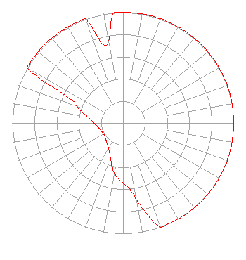
Directional Antenna
Antenna Make/Model: Electronics Research Inc. 100-1M-DA
Antenna ID: 131758
Polarization:
| Primary Station |
| WZUN(AM) |
Ch. 0 | Sandy Creek-pulaski, New York |
|
Structure Information
Structure Registration Number 1028674
Structure Type: GTOWER
Registered To:
PTI US Assets I, LLC
Structure Address:
St Rt 481 At Dutch Ridge Rd
Oswego, NY
County Name: Oswego County
ASR Issued: 06/10/2019
Date Built: 01/01/1996
Site Elevation: 106.7 m (350 ft.)
Structure Height: 146.9 m (482 ft.)
Height Overall: 146.9 m (482 ft.)
Overall Height AMSL: 253.6 m (832 ft.)
FAA Determination: 03/10/2016
FAA Study #: 2014-AEA-7150-OE
FAA Circular #: 70/7460-1L
Paint & Light FAA Chapters: 4, 8, 12
PRIOR STUDY 1996-AEA-367-OE
43-24-56.0 N 76-27-53.0 W (NAD 83)
43-24-55.8 N 76-27-54.2 W
(Converted to NAD 27)
|
W291BU(FX) Licensee Information
Galaxy Syracuse Licensee LLC (New)
235 Walton Street
Syracuse, NY 13202
Phone: 315-472-9111
Limited Liability Company | 20180626AAB Applicant Information
Edward Levine
Date: 06/26/2018
Application Certifier
Galaxy Syracuse Licensee LLC
235 Walton Street
Syracuse, NY 13202-1351
Applicant
W. Jeffrey Reynolds
Du Treil, Lundin & Rackley, Inc.
3135 Southgate Circle
Sarasota, FL 34239-5515
Technical Consultant
Sally A. Buckman, Esq.
Lerman Senter PLLC
2001 L St NW
Suite 400
Washington, DC 20036
|