FCCInfo.com
A Service of Cavell, Mertz & Associates, Inc.
(855) FCC-INFO
|
|
K20JX from 11/08/2010 K20JX-D from 11/08/2010 K27EU from 12/20/1993 K56EN from 08/21/1990 891207PI from ??? |
Virtual Channel 27 |
|
||||||||||||||||||
|
|
Status: LIC Application Accepted: 10/06/2010 License Expires: 12/01/2022 File Number: BLDTA-20101006AAS Prefix Type: This is BLDTA FCC Website Links: LMS Facility Details This Application Other K20JX-D Applications Including Superseded Applications Service Contour - Open Street Map or USGS Map (51 dBu) Service Contour - KML / Google Earth (51 dBu) Public Inspection Files Rabbit Ears Info Search for K20JX-D Site Location: 38-49-58.0 N 121-19-09.0 W (NAD 83) Site Location: 38-49-58.4 N 121-19-05.2 W (Converted to NAD 27) ERP: 4.7 kW R/C AGL: 94 m (308 ft.) R/C AMSL: 135 m (443 ft.) Emission Mask: Stringent Site Elevation: 41 m. (135 ft.) Height Overall*: 101.1 m (332 ft.) (* As Filed In This Application, may differ from ASR Data, Below.) Directional Antenna - Antenna Make/Model: Scala 4DR-16S Antenna ID: 20735 | ||||||||||||||||||||
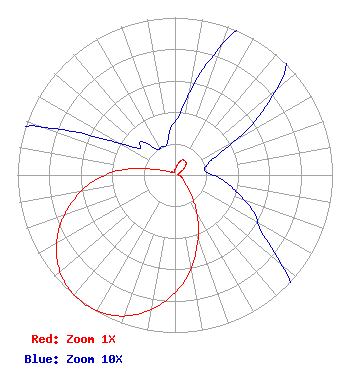
| Antenna Data for Antenna Id: 20735 K20JX-D DC File: BLDTA-20101006AAS Scala - 4DR-16S Service: DC Standard Pattern: Y Pattern and Field Values Include a 215° Clockwise Rotation |  | ||||||||||||||||||||
| Azimuth | Ratio | Azimuth | Ratio | Azimuth | Ratio | Azimuth | Ratio | ||||||||||||||
| 5 | 0.040 | 15 | 0.070 | 25 | 0.105 | 35 | 0.110 | ||||||||||||||
| 45 | 0.100 | 55 | 0.065 | 65 | 0.030 | 75 | 0.020 | ||||||||||||||
| 85 | 0.020 | 95 | 0.030 | 105 | 0.040 | 115 | 0.055 | ||||||||||||||
| 125 | 0.070 | 135 | 0.115 | 145 | 0.210 | 155 | 0.350 | ||||||||||||||
| 165 | 0.510 | 175 | 0.680 | 185 | 0.810 | 195 | 0.915 | ||||||||||||||
| 205 | 0.980 | 215 | 1.000 | 225 | 0.980 | 235 | 0.917 | ||||||||||||||
| 245 | 0.813 | 255 | 0.680 | 265 | 0.530 | 275 | 0.350 | ||||||||||||||
| 285 | 0.140 | 295 | 0.060 | 305 | 0.030 | 315 | 0.030 | ||||||||||||||
| 325 | 0.020 | 335 | 0.020 | 345 | 0.020 | 355 | 0.030 | ||||||||||||||
Structure Registration Number 1014128 Structure Type: 6TA3 Registered To: New Inspiration Broadcasting Co., Inc. Structure Address: Twr 3 1701 Athens Ave Lincoln, CA County Name: Placer County ASR Issued: 01/25/2006 Date Built: 08/01/1996 Site Elevation: 41.1 m (135 ft.) Structure Height: 100 m (328 ft.) Height Overall: 101 m (331 ft.) Overall Height AMSL: 142.1 m (466 ft.) FAA Determination: 09/17/1996 FAA Study #: 95-AWP-805-OE FAA Circular #: 70/7460-1H Paint & Light FAA Chapters: 4, 6, 13 6 TOWER ARRAY. TOWERS 1, 3, 5 & 6 HAVE MEDIUM INTENSITY LIGHTS, TOWERS 2 & 4 HAVE NO OM&L. 38-49-58.0 N 121-19-09.0 W (NAD 83) 38-49-58.4 N 121-19-05.2 W (Converted to NAD 27) |
6615 Sierra College Boulevard Granite Bay, CA 95746 Phone: 916-209-7242 Not-for-Profit | Date: 10/06/2010 Application Certifier Abundant Life Broadcasting PO Box 299 Roseville, CA 95678 Applicant Daniel N. Peek PO Box 220 West Frankfort, IL 62896-0220 Engineer Bonnie Ensminger Amazing Facts | |||||||||||||||||||
| |||||||||||||||||||||