|
W248CU Channel: 248D 97.5 MHz
Minneapolis, Minnesota
Service: FX - A translator or application for a translator.
Facility ID: 138656
FRN: 0006005672
Fac. Service: FX
Programming Delivery Method: Unspecified
Status: LIC
Application Accepted: 06/22/2017
Application Granted: 07/03/2017
File Number: BLFT-20170622ACC
License Expires: 04/01/2029
Prefix Type: This is a license for a translator
Application Type: License To Cover
FCC Website Links:
LMS Facility Details
This Application
Other W248CU Applications
Including Superseded Applications
Service Contour - Open Street Map or USGS Map (60 dBu)
Service Contour - KML / Google Earth (60 dBu)
Class: D, A Noncommercial educational operating with no more than 10W
Site Location: 44-56-44.9 N 93-05-31.8 W (NAD 83)
Site Location: 44-56-45.0 N 93-05-31.0 W (Converted to NAD 27)
Effective Radiated Power: 0.25 kW
Transmitter Output Power: 0.402 kW
Antenna Center AMSL: 375 m (1230 ft.)
Antenna Center HAG: 143 m (469 ft.)
Site Elevation: 232 m. (761 ft.)
Height Overall*: 148 m (486 ft.)
(* As Filed In This Application, may differ from ASR Data, Below.)
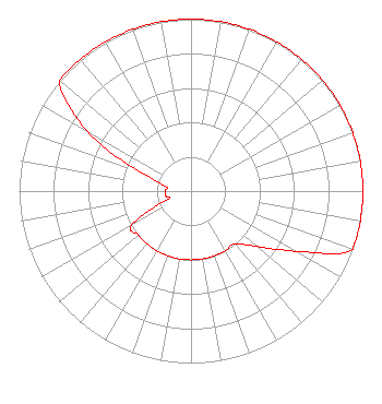
Directional Antenna
Antenna Make/Model: Propagation System Inc FML-1
Antenna ID: 127084
Polarization:
| Primary Station |
| KTIS(AM) |
Ch. 0 | Minneapolis, Minnesota |
|
Structure Information
Structure Registration Number 1218256
[ASR Heights Differ from W248CU Application]
Structure Type: BTWR
Registered To:
First Bank Building, LLC
Structure Address:
332 Minnesota Street
St. Paul, MN
County Name: Ramsey County
ASR Issued: 08/01/2023
Date Built: 12/21/1931
Site Elevation: 231.3 m (759 ft.)
Structure Height: 121.9 m (400 ft.)
Height Overall: 156.1 m (512 ft.)
Overall Height AMSL: 387.4 m (1271 ft.)
FAA Determination: 12/20/2022
FAA Study #: 2022-AGL-23018-OE
Paint & Light FAA Chapters: 3, 4, 13, 21
Continue As Is OM&L = RED LIGHTS
44-56-47.0 N 93-05-28.5 W (NAD 83)
44-56-47.1 N 93-05-27.7 W
(Converted to NAD 27)
|
W248CU(FX) Licensee Information
University of Northwestern-St. Paul
3003 Snelling Ave N
Saint Paul, MN 55113-1501
Phone: 651-631-5000
| 20170622ACC Applicant Information
Alan S. Cureton
Date: 06/22/2017
Application Certifier
University of Northwestern-St. Paul
3003 Snelling Avenue North
St. Paul, MN 55113
Applicant
Charles M. Anderson
1519 Euclid Avenue
Bowling Green, KY 42103
Consultant
Joseph C. Chautin, III
Hardy, Carey, Chautin & Balkin, LLP
1080 West Causeway Approach
Mandeville, LA 70471
|