FCCInfo.com
A Service of Cavell, Mertz & Associates, Inc.
(855) FCC-INFO
|
|
KAAL-TV from 12/01/1982 KAAL from ??? |
Virtual Channel 6 |
|
||||||||||||||||||||||||||||
|
|
Status: LIC Application Accepted: 10/09/2009 License Expires: 04/01/2030 File Number: BLCDT-20091009AAG Prefix Type: This is a License for a commercial digital TV station FCC Website Links: LMS Facility Details This Application Other KAAL Applications Including Superseded Applications Service Contour - Open Street Map or USGS Map (51 dBu) Service Contour - KML / Google Earth (51 dBu) Rabbit Ears Info Search for KAAL Site Location: 43-06-21.3 N 93-35-07.3 W (NAD 83) Site Location: 43-06-21.4 N 93-35-06.5 W (Converted to NAD 27) ERP: 8.3 kW Electrical Beam Tilt: 1 degree R/C AGL: 80.8 m (265 ft.) R/C AMSL: 448.4 m (1471 ft.) Emission Mask: Stringent Site Elevation: 367.6 m. (1206 ft.) Height Overall*: 106.4 m (349 ft.) (* As Filed In This Application, may differ from ASR Data, Below.) Directional Antenna - Antenna Make/Model: DIELECTRIC DL-8 Antenna ID: 92972 | ||||||||||||||||||||||||||||||
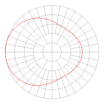
| Antenna Data for Antenna Id: 92972 KAAL LD File: BLCDT-20091009AAG DIELECTRIC - DL-8 Service: LD Standard Pattern: Y Pattern and Field Values Include a 270° Clockwise Rotation |  | ||||||||||||||||||||||||||||||
| Azimuth | Ratio | Azimuth | Ratio | Azimuth | Ratio | Azimuth | Ratio | ||||||||||||||||||||||||
| 0 | 0.661 | 10 | 0.615 | 20 | 0.583 | 30 | 0.569 | ||||||||||||||||||||||||
| 40 | 0.571 | 50 | 0.586 | 60 | 0.607 | 70 | 0.627 | ||||||||||||||||||||||||
| 80 | 0.640 | 90 | 0.645 | 100 | 0.641 | 110 | 0.631 | ||||||||||||||||||||||||
| 120 | 0.613 | 130 | 0.592 | 140 | 0.579 | 150 | 0.570 | ||||||||||||||||||||||||
| 160 | 0.579 | 170 | 0.610 | 180 | 0.650 | 190 | 0.699 | ||||||||||||||||||||||||
| 200 | 0.759 | 210 | 0.817 | 220 | 0.869 | 230 | 0.914 | ||||||||||||||||||||||||
| 240 | 0.951 | 250 | 0.975 | 260 | 0.993 | 270 | 1.000 | ||||||||||||||||||||||||
| 280 | 0.996 | 290 | 0.981 | 300 | 0.955 | 310 | 0.920 | ||||||||||||||||||||||||
| 320 | 0.876 | 330 | 0.826 | 340 | 0.771 | 350 | 0.714 | ||||||||||||||||||||||||
Structure Registration Number 1247759 Structure Type: TOWER Registered To: SBA Towers II LLC Structure Address: 2035 235th Street Garner, IA County Name: Hancock County ASR Issued: 06/03/2008 Date Built: 08/17/2005 Site Elevation: 367.6 m (1206 ft.) Structure Height: 103.6 m (340 ft.) Height Overall: 106.4 m (349 ft.) Overall Height AMSL: 474 m (1555 ft.) FAA Determination: 03/01/2005 FAA Study #: 2005-ACE-456-OE FAA Circular #: 70/7460-1K Paint & Light FAA Chapters: 4, 8, 12 Removed expiration date from determination. Scenario 1./jjs/case#635066 43-06-21.3 N 93-35-07.3 W (NAD 83) 43-06-21.4 N 93-35-06.5 W (Converted to NAD 27) |
1320 Salem Rd SW Rochester, MN 55902 Phone: 507-258-7228 Limited Liability Company | Date: 10/09/2009 Application Certifier KAAL-TV, LLC 3415 University Avenue, West St. Paul, MN 55114-2099 Applicant Jerome J. Manarchuck Du Treil, Lundin & Rackley, Inc. 201 Fletcher Ave. Sarasota, FL 34237 Technical Consultant Charles R. Naftalin, Esq. Holland & Knight LLP | |||||||||||||||||||||||||||||
| |||||||||||||||||||||||||||||||