|
K264AF Channel: 264D 100.7 MHz
Guasti, California
Service: FX - A translator or application for a translator.
Facility ID: 87064
FRN: 0035489673
Fac. Service: FX
Programming Delivery Method: Unspecified
Status: LIC
Application Accepted: 12/23/2014
Application Granted: 02/03/2015
File Number: BLFT-20141223ABO
License Expires: 12/01/2029
Prefix Type: This is a license for a translator
Application Type: License To Cover
FCC Website Links:
LMS Facility Details
This Application
Other K264AF Applications
Including Superseded Applications
Service Contour - Open Street Map or USGS Map (60 dBu)
Service Contour - KML / Google Earth (60 dBu)
Class: D, A Noncommercial educational operating with no more than 10W
Site Location: 34-02-18.0 N 117-53-24.2 W (NAD 83)
Site Location: 34-02-18.0 N 117-53-21.0 W (Converted to NAD 27)
Effective Radiated Power: 0.25 kW
Transmitter Output Power: 0.091 kW
Antenna Center AMSL: 418 m (1371 ft.)
Antenna Center HAG: 55 m (180 ft.)
Site Elevation: 363 m. (1191 ft.)
Height Overall*: 64 m (210 ft.)
(* As Filed In This Application, may differ from ASR Data, Below.)
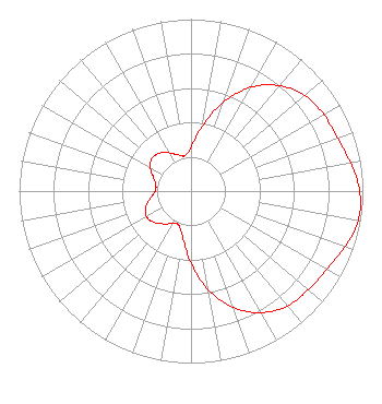
Directional Antenna
Antenna Make/Model: Scala CA5-FM/CP/RM/50N
Antenna ID: 115000
Polarization:
| Primary Station |
| KKLQ(FM) |
Ch. 262 | Los Angeles, California |
|
Structure Information
Structure Registration Number 1014666
[ASR Heights Differ from K264AF Application]
Structure Type: LTOWER
Registered To:
City of West Covina
Structure Address:
2210 S. Azusa Avenue
West Covina, CA
County Name: Los Angeles County
ASR Issued: 12/09/2022
Date Built: 11/01/1984
Site Elevation: 364.2 m (1195 ft.)
Structure Height: 61 m (200 ft.)
Height Overall: 65.2 m (214 ft.)
Overall Height AMSL: 429.4 m (1409 ft.)
FAA Determination: 08/31/2022
FAA Study #: 2022-AWP-12002-OE
FAA Circular #: 70/7460-1K
Paint & Light FAA Chapters: 3, 4, 5, 12
OM&L to remain the same as prior study = PAINT/RED LIGHTS
34-02-17.6 N 117-53-24.1 W (NAD 83)
34-02-17.6 N 117-53-20.9 W
(Converted to NAD 27)
|
K264AF(FX) Licensee Information
K-Love, Inc.
2000 Reams Fleming Boulevard
Franklin, TN 37064
Phone: 916-251-1600
Not-for-Profit | 20141223ABO Applicant Information
Mike Novak
Date: 12/23/2014
Application Certifier
Educational Media Foundation
5700 West Oaks Blvd
Rocklin, CA 95765
Applicant
Mary N. O'Connor
Wilkinson Barker Knauer, LLP
2300 N Street, N.W.
Suite 700
Washington, DC 20037-1128
Stephen Wilde
5700 West Oaks Blvd
Rocklin, CA 95765
Broadcast Engineer
|