FCCInfo.com
A Service of Cavell, Mertz & Associates, Inc.
(855) FCC-INFO
|
|
|
|
|
||||||||||||||||
|
|
Status: CP Application Accepted: 08/25/2009 File Number: BNPDTL-20090825AYS Prefix Type: This is BNPDTL FCC Website Links: LMS Facility Details This Application Other K14TL-D Applications Including Superseded Applications Mailing Address Correspondence for K14TL-D Correspondence related to application BNPDTL-20090825AYS Service Contour - Open Street Map or USGS Map (51 dBu) Service Contour - KML / Google Earth (51 dBu) Rabbit Ears Info Search for K14TL-D Site Location: 30-06-35.6 N 94-01-42.3 W (NAD 83) Site Location: 30-06-34.8 N 94-01-41.7 W (Converted to NAD 27) ERP: 1 kW R/C AGL: 150 m (492 ft.) R/C AMSL: 151.8 m (498 ft.) Emission Mask: Stringent Site Elevation: 1.8 m. (6 ft.) Height Overall*: 173.7 m (570 ft.) (* As Filed In This Application, may differ from ASR Data, Below.) Directional Antenna - Antenna Make/Model: MICRO COMMUNICATIONS INC 955312 Antenna ID: 103076 | ||||||||||||||||||
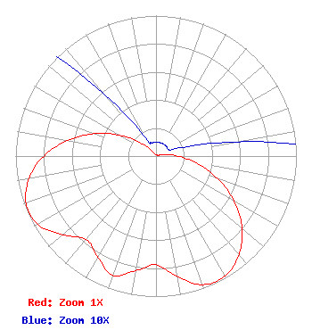
| Antenna Data for Antenna Id: 103076 K14TL-D LD File: BNPDTL-20090825AYS MICRO COMMUNICATIONS INC - 955312 Service: LD Standard Pattern: Y |  | ||||||||||||||||||
| Azimuth | Ratio | Azimuth | Ratio | Azimuth | Ratio | Azimuth | Ratio | ||||||||||||
| 0 | 0.010 | 10 | 0.010 | 20 | 0.010 | 30 | 0.010 | ||||||||||||
| 40 | 0.010 | 50 | 0.010 | 60 | 0.010 | 70 | 0.015 | ||||||||||||
| 80 | 0.058 | 90 | 0.156 | 100 | 0.298 | 110 | 0.467 | ||||||||||||
| 120 | 0.642 | 130 | 0.800 | 140 | 0.919 | 150 | 0.984 | ||||||||||||
| 160 | 0.974 | 170 | 0.870 | 180 | 0.774 | 190 | 0.829 | ||||||||||||
| 200 | 0.902 | 210 | 0.829 | 220 | 0.774 | 230 | 0.870 | ||||||||||||
| 240 | 0.974 | 250 | 0.984 | 260 | 0.919 | 270 | 0.800 | ||||||||||||
| 280 | 0.642 | 290 | 0.467 | 300 | 0.298 | 310 | 0.156 | ||||||||||||
| 320 | 0.058 | 330 | 0.015 | 340 | 0.010 | 350 | 0.010 | ||||||||||||
Structure Registration Number 1049616 [ASR Heights Differ from K14TL-D Application] Structure Type: Registered To: American Towers LLC Structure Address: 1110 Old Spanish Trail (004293) Vidor, TX County Name: Orange County ASR Issued: 06/23/2016 Date Built: 04/20/2011 Site Elevation: 1.8 m (6 ft.) Structure Height: 176.8 m (580 ft.) Height Overall: 181.4 m (595 ft.) Overall Height AMSL: 183.2 m (601 ft.) FAA Determination: 04/28/2011 FAA Study #: 2011-ASW-2297-OE Paint & Light FAA Chapters: 1, 3, 4, 13, 21 PRIOR STUDY 2009-ASW-6196-OE 30-06-35.6 N 94-01-42.3 W (NAD 83) 30-06-34.8 N 94-01-41.7 W (Converted to NAD 27) |
Montgomery, TX 77356 Phone: 936-443-4451 Individual | Date: 08/25/2009 Application Certifier MIK, LLC 1112 Weston Road Suite 255 Weston, FL 33326 Applicant James Gallagher 10120 Briar Circle Hudson, FL 34667 Consultant James Gallagher King Forward, Inc. 1671 NW 144th Terrace Suite 106 Sunrise, FL 33323 | |||||||||||||||||