FCCInfo.com
A Service of Cavell, Mertz & Associates, Inc.
(855) FCC-INFO
|
|
KSWT from 09/13/1991 KYEL-TV from 09/18/1978 KYEL from ??? |
Virtual Channel 13 |  |
|
||||||||||||||||||||||||
|
|
Status: LIC Application Accepted: 04/26/2012 License Expires: 10/01/2030 File Number: BLCDT-20120426ABZ Prefix Type: This is a License for a commercial digital TV station FCC Website Links: LMS Facility Details This Application Other KYMA-DT Applications Including Superseded Applications Service Contour - Open Street Map or USGS Map (36 dBu) Service Contour - KML / Google Earth (36 dBu) Public Inspection Files Rabbit Ears Info Search for KYMA-DT Site Location: 33-03-18.5 N 114-49-41.6 W (NAD 83) Site Location: 33-03-18.4 N 114-49-38.7 W (Converted to NAD 27) ERP: 50 kW Polarization: Horizontally polarized HAAT: 480 m (1575 ft.) R/C AGL: 116 m (381 ft.) R/C AMSL: 763.7 m (2506 ft.) Site Elevation: 647.7 m. (2125 ft.) Height Overall*: 122.8 m (403 ft.) (* As Filed In This Application, may differ from ASR Data, Below.) Directional Antenna - Antenna Make/Model: Jampro ODDKYELTV Antenna ID: 108296 Polarization: Horizontally polarized | |||||||||||||||||||||||||||
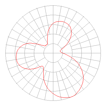
| Antenna Data for Antenna Id: 108296 KYMA-DT DT File: BLCDT-20120426ABZ Jampro - ODDKYELTV Service: DT Standard Pattern: Y |  | |||||||||||||||||||||||||||
| Azimuth | Ratio | Azimuth | Ratio | Azimuth | Ratio | Azimuth | Ratio | |||||||||||||||||||||
| 0 | 0.620 | 10 | 0.670 | 20 | 0.690 | 30 | 0.670 | |||||||||||||||||||||
| 40 | 0.600 | 50 | 0.470 | 60 | 0.300 | 70 | 0.170 | |||||||||||||||||||||
| 80 | 0.160 | 90 | 0.200 | 100 | 0.330 | 110 | 0.520 | |||||||||||||||||||||
| 120 | 0.690 | 130 | 0.830 | 140 | 0.920 | 150 | 0.980 | |||||||||||||||||||||
| 155 | 1.000 | 160 | 0.990 | 170 | 0.940 | 180 | 0.850 | |||||||||||||||||||||
| 190 | 0.730 | 200 | 0.570 | 210 | 0.400 | 220 | 0.360 | |||||||||||||||||||||
| 230 | 0.510 | 240 | 0.660 | 250 | 0.750 | 260 | 0.780 | |||||||||||||||||||||
| 270 | 0.760 | 280 | 0.700 | 290 | 0.580 | 300 | 0.370 | |||||||||||||||||||||
| 310 | 0.230 | 320 | 0.220 | 330 | 0.230 | 340 | 0.340 | |||||||||||||||||||||
| 350 | 0.500 | |||||||||||||||||||||||||||
Structure Registration Number 1002752 Structure Type: GTOWER Registered To: Imagicomm Yuma Operations LLC Structure Address: Black Mountain 17.5 Mi N Ogilby, CA County Name: Imperial County ASR Issued: 09/27/2022 Date Built: 01/01/1977 Site Elevation: 647.7 m (2125 ft.) Structure Height: 121.9 m (400 ft.) Height Overall: 122.8 m (403 ft.) Overall Height AMSL: 770.5 m (2528 ft.) FAA Determination: 01/09/2012 FAA Study #: 2011-AWP-8122-OE FAA Circular #: 70/7460-1J Paint & Light FAA Chapters: 3, 4, 5, 13 PRIOR STUDY 1996-AWP-2538-OE 33-03-18.5 N 114-49-41.6 W (NAD 83) 33-03-18.4 N 114-49-38.7 W (Converted to NAD 27) |
3000 Worldreach Drive Indian Land, SC 29707 Phone: 803-578-1418 Limited Liability Company | Date: 04/26/2012 Application Certifier Pappas Arizona License, LLC 823 West Center Avenue Visalia, CA 93291 Applicant Kevin T. Fisher 2237 Tacketts Mill Drive Suite A Lake Ridge, VA 22192 Engineering Consultant Kathleen Victory Fletcher Heald & Hildreth, PLC 1300 N. 17th Street Suite 1100 Arlington, VA 22209 | ||||||||||||||||||||||||||
|
| |||||||||||||||||||||||||||