FCCInfo.com
A Service of Cavell, Mertz & Associates, Inc.
(855) FCC-INFO
|
|
KEVU from 09/04/1987 860711KE from ??? |
Virtual Channel 34 |  |
|
||||||||||||||||||||||||||||||||||||||||||||||||
|
|
Status: LIC Application Accepted: 01/04/2007 License Expires: 02/01/2031 File Number: BLCDT-20070104ADQ Prefix Type: This is a License for a commercial digital TV station FCC Website Links: LMS Facility Details This Application Other KLSR-TV Applications Including Superseded Applications Service Contour - Open Street Map or USGS Map (41 dBu) Service Contour - KML / Google Earth (41 dBu) Public Inspection Files Rabbit Ears Info Search for KLSR-TV Site Location: 44-00-03.0 N 123-06-49.0 W (NAD 83) Site Location: 44-00-03.6 N 123-06-44.7 W (Converted to NAD 27) ERP: 88 kW Polarization: Horizontally polarized HAAT: 372 m (1220 ft.) Electrical Beam Tilt: 1.5 degrees R/C AGL: 176.8 m (580 ft.) R/C AMSL: 571.8 m (1876 ft.) Site Elevation: 395 m. (1296 ft.) Height Overall*: 199 m (653 ft.) (* As Filed In This Application, may differ from ASR Data, Below.) Directional Antenna - Antenna Make/Model: Kathrein K723147 (4X3) Antenna ID: 67996 Polarization: Horizontally polarized | |||||||||||||||||||||||||||||||||||||||||||||||||||
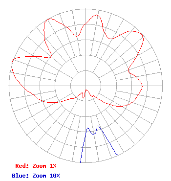
| Antenna Data for Antenna Id: 67996 KLSR-TV DT File: BLCDT-20070104ADQ Kathrein - K723147 (4X3) Service: DT Standard Pattern: Y |  | |||||||||||||||||||||||||||||||||||||||||||||||||||
| Azimuth | Ratio | Azimuth | Ratio | Azimuth | Ratio | Azimuth | Ratio | |||||||||||||||||||||||||||||||||||||||||||||
| 0 | 0.803 | 10 | 0.924 | 20 | 0.726 | 30 | 0.701 | |||||||||||||||||||||||||||||||||||||||||||||
| 40 | 0.922 | 50 | 0.976 | 60 | 0.771 | 70 | 0.590 | |||||||||||||||||||||||||||||||||||||||||||||
| 80 | 0.661 | 90 | 0.736 | 100 | 0.696 | 110 | 0.643 | |||||||||||||||||||||||||||||||||||||||||||||
| 120 | 0.540 | 130 | 0.360 | 140 | 0.183 | 150 | 0.159 | |||||||||||||||||||||||||||||||||||||||||||||
| 160 | 0.062 | 170 | 0.064 | 180 | 0.063 | 190 | 0.162 | |||||||||||||||||||||||||||||||||||||||||||||
| 200 | 0.107 | 210 | 0.117 | 220 | 0.207 | 230 | 0.271 | |||||||||||||||||||||||||||||||||||||||||||||
| 240 | 0.440 | 250 | 0.591 | 260 | 0.689 | 270 | 0.831 | |||||||||||||||||||||||||||||||||||||||||||||
| 280 | 0.951 | 287 | 1.000 | 290 | 0.991 | 300 | 0.759 | |||||||||||||||||||||||||||||||||||||||||||||
| 310 | 0.582 | 320 | 0.836 | 330 | 0.988 | 340 | 0.841 | |||||||||||||||||||||||||||||||||||||||||||||
| 350 | 0.649 | |||||||||||||||||||||||||||||||||||||||||||||||||||
Structure Registration Number 1034933 Structure Type: Registered To: EIP Holdings II, LLC Structure Address: 4585 Blanton Rd Eugene, OR County Name: Lane County ASR Issued: 11/30/2023 Date Built: 01/01/1987 Site Elevation: 395 m (1296 ft.) Structure Height: 198.1 m (650 ft.) Height Overall: 199 m (653 ft.) Overall Height AMSL: 594 m (1949 ft.) FAA Determination: 06/04/1990 FAA Study #: 90-ANM-0325-OE FAA Circular #: 70/7460-1G Paint & Light FAA Chapters: 3, 4, 5, 9 44-00-03.0 N 123-06-49.0 W (NAD 83) 44-00-03.6 N 123-06-44.7 W (Converted to NAD 27) |
1601 W. Peachtree Street, NE Atlanta, GA 30309 Phone: 404-897-7000 Limited Liability Company | Date: 01/04/2007 Application Certifier California Oregon Broadcasting, Inc. P. O. Box 1489 Medford, OR 97501 Applicant Karl D. Sargent California Oregon Broadcasting, Inc. 125 S. Fir Street Medford, OR 97501 Director of Engineering Marnie K. Sarver, Esq. Wiley Rein & Fielding LLP Wiley Rein & Fielding LLP 1776 K Street, NW Washington, DC 20006 | ||||||||||||||||||||||||||||||||||||||||||||||||||
| ||||||||||||||||||||||||||||||||||||||||||||||||||||