FCCInfo.com
A Service of Cavell, Mertz & Associates, Inc.
(855) FCC-INFO
|
|
KYCU-TV from 05/16/1979 KYCU from ??? |
Virtual Channel 5 |  |
|
||||||||||||||||||||||||||||||
|
|
Status: LIC Application Accepted: 03/27/2007 License Expires: 10/01/2030 File Number: BLCDT-20070327AEQ Prefix Type: This is a License for a commercial digital TV station FCC Website Links: LMS Facility Details This Application Other KGWN-TV Applications Including Superseded Applications Service Contour - Open Street Map or USGS Map (41 dBu) Service Contour - KML / Google Earth (41 dBu) Public Inspection Files Rabbit Ears Info Search for KGWN-TV Site Location: 41-06-00.4 N 105-00-25.2 W (NAD 83) Site Location: 41-06-00.5 N 105-00-23.3 W (Converted to NAD 27) ERP: 459 kW Polarization: Horizontally polarized HAAT: 162 m (531 ft.) Electrical Beam Tilt: 0.75 degrees R/C AGL: 118.4 m (388 ft.) R/C AMSL: 2184.4 m (7167 ft.) Site Elevation: 2066 m. (6778 ft.) Height Overall*: 147 m (482 ft.) (* As Filed In This Application, may differ from ASR Data, Below.) Directional Antenna - Antenna Make/Model: Electronics Research Inc. ALP32L3-HSN-30 Antenna ID: 74290 Polarization: Horizontally polarized
| |||||||||||||||||||||||||||||||||
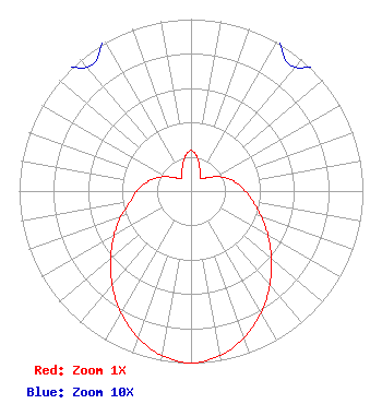
| Antenna Data for Antenna Id: 74290 KGWN-TV DT File: BLCDT-20070327AEQ Electronics Research Inc. - ALP32L3-HSN-30 Service: DT Standard Pattern: Y |  | |||||||||||||||||||||||||||||||||
| Azimuth | Ratio | Azimuth | Ratio | Azimuth | Ratio | Azimuth | Ratio | |||||||||||||||||||||||||||
| 0 | 0.236 | 10 | 0.202 | 20 | 0.147 | 30 | 0.104 | |||||||||||||||||||||||||||
| 40 | 0.094 | 50 | 0.120 | 60 | 0.168 | 70 | 0.221 | |||||||||||||||||||||||||||
| 80 | 0.269 | 90 | 0.316 | 100 | 0.368 | 110 | 0.435 | |||||||||||||||||||||||||||
| 120 | 0.517 | 130 | 0.611 | 140 | 0.713 | 150 | 0.815 | |||||||||||||||||||||||||||
| 160 | 0.906 | 170 | 0.972 | 180 | 1.000 | 190 | 0.972 | |||||||||||||||||||||||||||
| 200 | 0.906 | 210 | 0.815 | 220 | 0.713 | 230 | 0.611 | |||||||||||||||||||||||||||
| 240 | 0.517 | 250 | 0.435 | 260 | 0.358 | 270 | 0.316 | |||||||||||||||||||||||||||
| 280 | 0.269 | 290 | 0.221 | 300 | 0.168 | 310 | 0.120 | |||||||||||||||||||||||||||
| 320 | 0.094 | 330 | 0.104 | 340 | 0.147 | 350 | 0.202 | |||||||||||||||||||||||||||
Structure Registration Number 1008933 Structure Type: LTOWER Registered To: Marquee Broadcasting West, Inc. Structure Address: Us Hwy 30 10 Mi W Cheyenne, WY County Name: Laramie County ASR Issued: 07/01/2024 Date Built: 12/21/2012 Site Elevation: 2066.2 m (6779 ft.) Structure Height: 147 m (482 ft.) Height Overall: 147 m (482 ft.) Overall Height AMSL: 2213.2 m (7261 ft.) FAA Determination: 11/13/2012 FAA Study #: 2012-ANM-2130-OE Paint & Light FAA Chapters: 1, 3, 4, 13, 21 Continue As Is OM&L = PAINT/RED LIGHTS 41-06-00.4 N 105-00-25.2 W (NAD 83) 41-06-00.5 N 105-00-23.3 W (Converted to NAD 27) |
30 N Gould St Ste 24760 Sheridan, WY 82801 Phone: 301-661-9610 Corporation | Date: 03/27/2007 Application Certifier Sagamorehill Broadcasting of Wyoming/Northern Colorado, LLC 3825 Inverness Way Augusta, GA 30907 Applicant Craig Turner P.O. Box 20815 Raleigh, NC 27619 Consultant Todd M. Stansbury Wiley Rein LLP 1776 K Street, N.W. Washington, DC 20006 | ||||||||||||||||||||||||||||||||
| ||||||||||||||||||||||||||||||||||