|
W296ED Channel: 296D 107.1 MHz
Altoona, Pennsylvania
Service: FX - A translator or application for a translator.
Facility ID: 200530
FRN: 0026576223
Fac. Service: FX
Programming Delivery Method: Unspecified
Status: LIC
Application Accepted: 10/12/2018
Application Granted: 10/24/2018
File Number: BLFT-20181012AAB
License Expires: 08/01/2030
Prefix Type: This is a license for a translator
Application Type: License To Cover
FCC Website Links:
LMS Facility Details
This Application
Other W296ED Applications
Including Superseded Applications
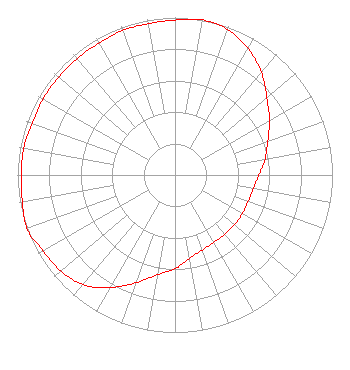
Service Contour - Open Street Map or USGS Map (60 dBu)
Service Contour - KML / Google Earth (60 dBu)
Class: D, A Noncommercial educational operating with no more than 10W
Site Location: 40-24-11.3 N 78-31-34.1 W (NAD 83)
Site Location: 40-24-11.0 N 78-31-35.0 W (Converted to NAD 27)
Effective Radiated Power: 0.094 kW
Transmitter Output Power: 0.254 kW
Antenna Center AMSL: 796 m (2612 ft.)
Antenna Center HAG: 20 m (66 ft.)
Site Elevation: 776 m. (2546 ft.)
Height Overall*: 30 m (98 ft.)
(* As Filed In This Application, may differ from ASR Data, Below.)
Directional Antenna
Antenna Make/Model: None
Antenna ID: 133533
Polarization:
| Primary Station |
| WYUP |
Ch. 0 | Loretto, Pennsylvania |
|
Structure Information
Structure Registration Number 1200175
Structure Type: Registered To:
Lightner Communications LLC
Structure Address:
7.8km Wsw Of Duncansville, Pa
Duncansville, PA
County Name: Blair County
ASR Issued: 10/16/2019
Date Built: 10/20/2000
Site Elevation: 776 m (2546 ft.)
Structure Height: 30 m (98 ft.)
Height Overall: 30 m (98 ft.)
Overall Height AMSL: 806 m (2644 ft.)
FAA Determination: 09/10/1997
FAA Study #: 97-AEA-1219-OE
Paint & Light FAA Chapters: NONE
Removed expiration date from determination. Scenario 1./jjs/case#635066
40-24-11.0 N 78-31-34.0 W (NAD 83)
40-24-10.7 N 78-31-34.9 W
(Converted to NAD 27)
|
W296ED(FX) Licensee Information
Lightner Communications, LLC
1771 Beaver Dam Road
Claysburg, PA 16625
Phone: 814-239-8323
| 20181012AAB Applicant Information
Matthew W. Lightner
Date: 10/12/2018
Application Certifier
Lightner Communications LLC
1771 Beaver Dam Road
Claysburg, PA 16625
Applicant
Matthew W. Lightner
1771 Beaver Dam Road
Claysburg, PA 16625-8913
Managing Member/Technical Director
Matthew W. Lightner
Lightner Communications LLC
1771 Beaver Dam Road
Claysburg, PA 16625
|