
FCCInfo.com
A Service of Cavell, Mertz & Associates, Inc.
(855) FCC-INFO
|
|
|
|  |
|
|||||||||||||||
|
|
KQEW Channel: 272C3 102.3 MHz Fordyce, Arkansas Service: FM - A full-service FM station or application. Facility ID: 15310 Fac. Service: FM Status: LIC 73.215 Station Application Accepted: 05/31/2001 Application Granted: 07/03/2001 File Number: BLH-20010531AAO Prefix Type: This is a license for a commercial FM station Application Type: License To Cover FCC Website Links: LMS Facility Details This Application CDBS Application Other KQEW Applications Other KQEW Applications in CDBS Including Superseded Applications Mailing Address Correspondence for KQEW Correspondence related to application BLH-20010531AAO Service Contour - Open Street Map or USGS Map (60 dBu) Service Contour - KML / Google Earth (60 dBu) Public Inspection Files History Cards for KQEW Facility Type: FM STATION Class: C3, A Zone II station; with 6kW-25kW ERP and a class contour distance 28km-39km Site Location: 33-48-10.4 N 92-26-10.5 W (NAD 83) Site Location: 33-48-10.0 N 92-26-09.9 W (Converted to NAD 27) Effective Radiated Power: 25 kW Transmitter Output Power: 10 kW Antenna Center HAAT: 100 m (328 ft.) Antenna Center AMSL: 176 m (577 ft.) Antenna Center HAG: 101 m (331 ft.) Calculated Site Elevation: 75 m. (246 ft.) Height Overall*: 109 m (358 ft.) (* As Filed In This Application, may differ from ASR Data, Below.) Directional Antenna Antenna Make/Model: DIELECTRIC SKM5EDA Antenna ID: 15924 Polarization: | ||||||||||||||||||
| Antenna Data for Antenna Id: 15924 KQEW FM File: BLH-20010531AAO DIELECTRIC - SKM5EDA Service: FM | 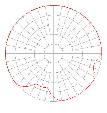 | ||||||||||||||||||
| Azimuth | Ratio | Azimuth | Ratio | Azimuth | Ratio | Azimuth | Ratio | ||||||||||||
| 0 | 1.000 | 10 | 1.000 | 20 | 1.000 | 30 | 1.000 | ||||||||||||
| 40 | 1.000 | 50 | 1.000 | 60 | 1.000 | 70 | 1.000 | ||||||||||||
| 80 | 1.000 | 90 | 1.000 | 100 | 0.900 | 110 | 0.880 | ||||||||||||
| 120 | 1.000 | 130 | 1.000 | 140 | 1.000 | 150 | 1.000 | ||||||||||||
| 160 | 1.000 | 170 | 1.000 | 180 | 0.900 | 190 | 0.740 | ||||||||||||
| 200 | 0.740 | 210 | 0.740 | 220 | 0.900 | 230 | 1.000 | ||||||||||||
| 240 | 1.000 | 250 | 1.000 | 260 | 1.000 | 270 | 1.000 | ||||||||||||
| 280 | 1.000 | 290 | 1.000 | 300 | 1.000 | 310 | 1.000 | ||||||||||||
| 320 | 1.000 | 330 | 1.000 | 340 | 1.000 | 350 | 1.000 | ||||||||||||
Structure Registration Number 1047440 [ASR Heights Differ from KQEW Application] Structure Type: TOWER Registered To: DALLAS PROPERTIES, INC Structure Address: End Of Brandon St 1.35 Mi Sw Of Courthouse Fordyce, AR County Name: Dallas County ASR Issued: 01/24/2001 Date Built: 05/10/2001 Site Elevation: 75.6 m (248 ft.) Structure Height: 105.4 m (346 ft.) Height Overall: 106.4 m (349 ft.) Overall Height AMSL: 182 m (597 ft.) FAA Determination: 12/29/2000 FAA Study #: 00-ASW-7595-OE FAA Circular #: 70/7460-1K Paint & Light FAA Chapters: 3, 4, 5, 12 Removed expiration date from determination. Scenario 1./jjs/case#635066 33-48-10.3 N 92-26-10.5 W (NAD 83) 33-48-09.9 N 92-26-09.9 W (Converted to NAD 27) |
303 Spring Street Fordyce, AR 71742 Corporation | Date: 05/31/2001 Application Certifier DALLAS PROPERTIES, INC. 303 Spring Street Fordyce, AR 71742 Applicant FRANK R. JAZZO, ESQUIRE Fletcher, Heald & Hildreth, P.l.c. FELIX MCDONALD 4721 Mcdonald Road Little Rock, AR 72206 CONSULTING ENGINEER | |||||||||||||||||
|
| ||||||||||||||||||