FCCInfo.com
A Service of Cavell, Mertz & Associates, Inc.
(855) FCC-INFO
|
|
KPTT from 10/18/2006 KMGG from 05/23/2005 KFMD from 11/13/2000 KHIH from 12/28/1993 KHOW-FM from 02/04/1991 KSYY from 06/15/1987 |
|
|
|||||||||||||||||||||||||
|
|
KDHT Channel: 239C0 95.7 MHz Denver, Colorado Service: FS - A full service FM station auxiliary transmitting antenna or application. Facility ID: 48967 FRN: 0014042816 Fac. Service: FM Analog & Digital Status: LIC Application Accepted: 08/13/2008 Application Granted: 08/28/2008 File Number: BXLH-20080813AAX License Expires: 04/01/2029 Prefix Type: This is BXLH Application Type: License To Cover FCC Website Links: LMS Facility Details This Application Other KDHT Applications Including Superseded Applications Service Contour - Open Street Map or USGS Map (60 dBu) Service Contour - KML / Google Earth (60 dBu) Public Inspection Files Facility Type: FM STATION Class: C0, C0 Site Location: 40-05-46.9 N 104-54-05.9 W (NAD 83) Site Location: 40-05-47.0 N 104-54-04.0 W (Converted to NAD 27) Effective Radiated Power: 85 kW Transmitter Output Power: 17.1 kW Antenna Center HAAT: 366 m (1201 ft.) Antenna Center AMSL: 1885 m (6184 ft.) Antenna Center HAG: 335 m (1099 ft.) Calculated Site Elevation: 1550 m. (5085 ft.) Height Overall*: 353.9 m (1161 ft.) (* As Filed In This Application, may differ from ASR Data, Below.) Directional Antenna Antenna Make/Model: Electronics Research Inc. 1061-3CP-DA Antenna ID: 85590 Polarization:
| |||||||||||||||||||||||||||
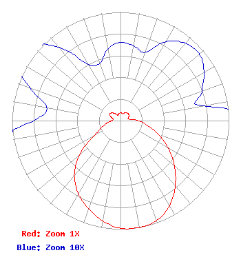
| Antenna Data for Antenna Id: 85590 KDHT FS File: BXLH-20080813AAX Electronics Research Inc. - 1061-3CP-DA Service: FS |  | |||||||||||||||||||||||||||
| Azimuth | Ratio | Azimuth | Ratio | Azimuth | Ratio | Azimuth | Ratio | |||||||||||||||||||||
| 0 | 0.072 | 10 | 0.070 | 20 | 0.067 | 30 | 0.084 | |||||||||||||||||||||
| 40 | 0.093 | 50 | 0.095 | 60 | 0.089 | 70 | 0.080 | |||||||||||||||||||||
| 80 | 0.077 | 90 | 0.165 | 100 | 0.256 | 110 | 0.375 | |||||||||||||||||||||
| 120 | 0.507 | 130 | 0.649 | 140 | 0.785 | 150 | 0.906 | |||||||||||||||||||||
| 160 | 0.978 | 170 | 1.000 | 180 | 0.992 | 190 | 0.939 | |||||||||||||||||||||
| 200 | 0.864 | 210 | 0.776 | 220 | 0.662 | 230 | 0.495 | |||||||||||||||||||||
| 240 | 0.282 | 250 | 0.183 | 260 | 0.125 | 270 | 0.080 | |||||||||||||||||||||
| 280 | 0.069 | 290 | 0.089 | 300 | 0.115 | 310 | 0.109 | |||||||||||||||||||||
| 320 | 0.088 | 330 | 0.060 | 340 | 0.056 | 350 | 0.067 | |||||||||||||||||||||
Structure Registration Number 1034537 [ASR Heights Differ from KDHT Application] Structure Type: GTOWER Registered To: Vertical Bridge CC FM, LLC Structure Address: 6750 Weld Co. Rd. #17 Frederick, CO County Name: Weld County ASR Issued: 09/29/2025 Date Built: 06/01/1996 Site Elevation: 1551.4 m (5090 ft.) Structure Height: 353.2 m (1159 ft.) Height Overall: 356.6 m (1170 ft.) Overall Height AMSL: 1908 m (6260 ft.) FAA Determination: 10/25/2022 FAA Study #: 2022-ANM-2912-OE FAA Circular #: 70/7460-1M Paint & Light FAA Chapters: 4, 9, 15 PRIOR STUDY 2015-ANM-1988-OE 40-05-47.3 N 104-54-05.9 W (NAD 83) 40-05-47.4 N 104-54-04.0 W (Converted to NAD 27) |
7136 S. Yale Avenue Suite 501 Tulsa, OK 74136 Phone: 918-664-4581 | Date: 08/13/2008 Application Certifier Citicasters Licenses, L.P. 2625 S. Memorial Drive Suite A Tulsa, OK 74129-2623 Applicant Samuel T. Cox, P.E. 2625 S. Memorial Drive Suite A Tulsa, OK 74129 Regional Engineer Troy Langham Clear Channel | ||||||||||||||||||||||||||
| ||||||||||||||||||||||||||||