
FCCInfo.com
A Service of Cavell, Mertz & Associates, Inc.
(855) FCC-INFO
|
|
WSRB from 04/22/2001 WSRB from 03/26/2001 WSRB from 03/16/2001 WSRB from 06/05/1997 WSRB from 12/15/1994 WSRB from 04/15/1991 |
|  |
|
|||||||||||||||
|
|
WSRB Channel: 292A 106.3 MHz Lansing, Illinois Service: FM - A full-service FM station or application. Facility ID: 6590 Fac. Service: FM Analog & Digital Status: LIC 73.215 Station Application Accepted: 12/19/2003 Application Granted: 01/09/2004 File Number: BLH-20031219AAA Prefix Type: This is a license for a commercial FM station Application Type: Amendment FCC Website Links: LMS Facility Details This Application CDBS Application Other WSRB Applications Other WSRB Applications in CDBS Including Superseded Applications Mailing Address Correspondence for WSRB Correspondence related to application BLH-20031219AAA Service Contour - Open Street Map or USGS Map (60 dBu) Service Contour - KML / Google Earth (60 dBu) Public Inspection Files History Cards for WSRB Facility Type: FM STATION Class: A, A Zone I; I-A; or II station; with 0.1kW-6kW ERP and a class contour distance <=28km Site Location: 41-34-44.1 N 87-32-47.2 W (NAD 83) Site Location: 41-34-44.0 N 87-32-47.0 W (Converted to NAD 27) Effective Radiated Power: 4.1 kW Transmitter Output Power: 4.5 kW Antenna Center HAAT: 121 m (397 ft.) Antenna Center AMSL: 309 m (1014 ft.) Antenna Center HAG: 126 m (413 ft.) Calculated Site Elevation: 183 m. (600 ft.) Height Overall*: 128 m (420 ft.) (* As Filed In This Application, may differ from ASR Data, Below.) Directional Antenna Antenna Make/Model: Electronics Research Inc. LP-2E-DA-HW, two sections, .5 wavelength spaced Antenna ID: 64280 Polarization: | ||||||||||||||||||
| Antenna Data for Antenna Id: 64280 WSRB FM File: BLH-20031219AAA Electronics Research Inc. - LP-2E-DA-HW, two sections, .5 wavelength spaced Service: FM | 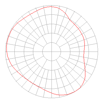 | ||||||||||||||||||
| Azimuth | Ratio | Azimuth | Ratio | Azimuth | Ratio | Azimuth | Ratio | ||||||||||||
| 0 | 0.966 | 10 | 0.942 | 20 | 0.873 | 30 | 0.791 | ||||||||||||
| 40 | 0.768 | 50 | 0.760 | 60 | 0.752 | 70 | 0.746 | ||||||||||||
| 80 | 0.724 | 90 | 0.702 | 100 | 0.708 | 110 | 0.754 | ||||||||||||
| 120 | 0.839 | 130 | 0.932 | 140 | 0.986 | 150 | 0.999 | ||||||||||||
| 160 | 0.984 | 170 | 0.949 | 180 | 0.894 | 190 | 0.840 | ||||||||||||
| 200 | 0.807 | 210 | 0.794 | 220 | 0.800 | 230 | 0.821 | ||||||||||||
| 240 | 0.856 | 250 | 0.903 | 260 | 0.941 | 270 | 0.966 | ||||||||||||
| 280 | 0.977 | 290 | 0.977 | 300 | 0.974 | 310 | 0.955 | ||||||||||||
| 320 | 0.930 | 330 | 0.922 | 340 | 0.933 | 350 | 0.957 | ||||||||||||
Structure Registration Number 1011693 Structure Type: TOWER Registered To: DONTRON INC Structure Address: 2915 Bernice Rd Lansing, IL County Name: Cook County ASR Issued: 09/05/2006 Date Built: 11/20/2001 Site Elevation: 182.9 m (600 ft.) Structure Height: 128 m (420 ft.) Height Overall: 128 m (420 ft.) Overall Height AMSL: 310.9 m (1020 ft.) FAA Determination: 07/30/2001 FAA Study #: 01-AGL-4260-OE FAA Circular #: 70/7460-1K Paint & Light FAA Chapters: 4, 8, 12 PRIOR STUDY 85-GL-1068-OE 41-34-44.0 N 87-32-47.0 W (NAD 83) 41-34-43.9 N 87-32-46.8 W (Converted to NAD 27) |
Blue Bell, PA 19422 Phone: 215-628-3500 Corporation | Date: 12/19/2003 Application Certifier DONTRON, INC. P.o. Box 3003 Blue Bell, PA 19422 Applicant W.C. ALEXANDER 2150 W. 29th Ave. Suite 300 Denver, CO 80211 DIRECTOR OF ENGINEERING JOHN NEELY, ESQ. Miller And Neely, P.c. | |||||||||||||||||
| |||||||||||||||||||