Accept
By using FCCInfo you agree to the terms & conditions. Read disclaimer Read privacy statement
FCCInfo.com

A Service of Cavell, Mertz & Associates, Inc.
(855) FCC-INFO

KZVU-LD
Call Sign History
KZVU-LD from 10/27/2009
KZVU-LP from 12/20/1996
K21DS from 07/30/1992
910430DI from ???
Channel 22DT

Chico, CA
License
CP
Application
Allocation
STA


KZVU-LD Service: LD - Digital TV Translator or LPTV Station
Channel: 22 Zone:
Chico, California
DTV TSID: 8001
Facility ID: 58612
FRN: 0026977595

Status: LIC
Application Accepted: 10/16/2009
License Expires: 12/01/2022
File Number: BLDTL-20091016ABN
Prefix Type: This is BLDTL

FCC Website Links:
  LMS Facility Details
  This Application
  Other KZVU-LD Applications
  Including Superseded Applications
  Service Contour - Open Street Map or USGS Map (51 dBu)
  Service Contour - KML / Google Earth (51 dBu)
  Rabbit Ears Info Search for KZVU-LD

Site Location: 39-57-45.0 N 121-42-44.0 W (NAD 83)
Site Location: 39-57-45.4 N 121-42-40.1 W (Converted to NAD 27)

ERP: 6 kW
Electrical Beam Tilt: -2.5 degrees
R/C AGL: 48 m (157 ft.)
R/C AMSL: 1127 m (3698 ft.)
Emission Mask: Stringent

Site Elevation: 1079 m. (3540 ft.)
Height Overall*: 123 m (404 ft.)
(* As Filed In This Application, may differ from ASR Data, Below.)
Directional Antenna - Antenna Make/Model: Antenna Concepts Inc. ACB12P1
Antenna ID: 17629

Antenna Data for Antenna Id: 17629
KZVU-LD LD File: BLDTL-20091016ABN
Antenna Concepts Inc. - ACB12P1
Service: LD
Standard Pattern: Y
Pattern and Field Values Include a 255° Clockwise Rotation
AzimuthRatioAzimuthRatioAzimuthRatioAzimuthRatio
50.270150.200250.180350.180
450.200550.220650.250750.280
850.250950.2201050.2001150.180
1250.2001350.2701450.3801550.520
1650.6701750.8101850.9201950.980
2050.9802150.9802250.8602350.660
2450.4402550.3802650.4402750.660
2850.8602950.9803050.9803150.920
3250.8103350.6703450.5203550.380
Structure Information

Structure Registration Number 1012346

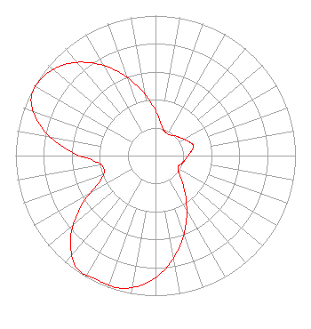
[ASR Heights Differ from KZVU-LD Application]
Structure Type: GTOWER
Registered To:
SBA GC Towers, LLC
Structure Address:
11045 Cohasset Rd (ca15878-a Tower 2)
Cohasset, CA
County Name: Butte County
ASR Issued: 07/26/2021
Date Built: 06/01/1988
Site Elevation: 1075.9 m (3530 ft.)
Structure Height: 122.2 m (401 ft.)
Height Overall: 124.1 m (407 ft.)
Overall Height AMSL: 1200 m (3937 ft.)
FAA Determination: 07/21/2021
FAA Study #: 2021-AWP-5874-OE
FAA Circular #: 70/7460-1M
Paint & Light FAA Chapters: 3, 4, 5, 15
PRIOR STUDY 1996-AWP-1759-OE
39-57-40.2 N 121-42-43.0 W (NAD 83)
39-57-40.6 N 121-42-39.1 W
(Converted to NAD 27)
KZVU-LD Licensee Information

Sinclair-California Licensee, LLC
C/O Miles S. Mason, Esq.
1200 Seventeenth Street, NW
Washington, DC 20036
Phone: 202-663-8195
Corporation
20091016ABN Applicant Information

Naomi L Smith
Date: 10/16/2009
Application Certifier
Sainte Partners II, LP
P.O. Box 4159
Modesto, CA 95352
Applicant
Mel Freedman
2612 Portsmouth Lane
Modesto, CA 95355-3915
Consulting Radio Engineer
Gregg P. Skall, Esq.
Womble Carlyle Sandridge & Rice, PLLC

Associated Land Mobile Licenses


(No Records Found)
Associated Microwave Licenses


(No Records Found)

Study Date: 4/01/2025; Study Duration: 0.0993 Seconds.
Database Sources:
04/01/2025 FCC LMS,
4/1/2025 FCC ASR,
4/1/2025 FCC ULS Microwave, and
4/1/2025 FCC ULS Broadcast Land Mobile.


© 2025 Capitol Airspace Group, LLC.
Alexandria, Virginia


If you have questions or concerns about the station above please contact the station Licensee.
Comments and questions about FCCInfo can be emailed to: webmaster@fccinfo.com