|
W238CH Channel: 238D 95.5 MHz
Decatur, Illinois
Service: FX - A translator or application for a translator.
Facility ID: 138378
FRN: 0002844348
Fac. Service: FX
Programming Delivery Method: Unspecified
Status: LIC
Application Accepted: 05/13/2014
Application Granted: 06/17/2014
File Number: BLFT-20140513ABI
License Expires: 12/01/2028
Prefix Type: This is a license for a translator
Application Type: License To Cover
FCC Website Links:
LMS Facility Details
This Application
Other W238CH Applications
Including Superseded Applications
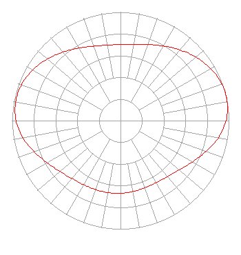
Service Contour - Open Street Map or USGS Map (60 dBu)
Service Contour - KML / Google Earth (60 dBu)
Class: D, A Noncommercial educational operating with no more than 10W
Site Location: 39-47-11.1 N 88-59-29.3 W (NAD 83)
Site Location: 39-47-11.0 N 88-59-29.0 W (Converted to NAD 27)
Effective Radiated Power: 0.25 kW
Transmitter Output Power: 0.636 kW
Antenna Center AMSL: 274 m (899 ft.)
Antenna Center HAG: 63 m (207 ft.)
Site Elevation: 211 m. (692 ft.)
Height Overall*: 105 m (344 ft.)
(* As Filed In This Application, may differ from ASR Data, Below.)
Directional Antenna
Antenna Make/Model: None
Antenna ID: 115250
Polarization:
| Primary Station |
| WYDS |
Ch. 226 | Decatur, Illinois |
|
Structure Information
Structure Registration Number 1057133
Structure Type: TOWER
Registered To:
THE CROMWELL GROUP, INC. OF ILLINOIS
Structure Address:
0.75 Miles N.w.
Elwin, IL
County Name: Macon County
ASR Issued: 03/14/2017
Date Built: 05/03/2002
Site Elevation: 211 m (692 ft.)
Structure Height: 104.2 m (342 ft.)
Height Overall: 104.8 m (344 ft.)
Overall Height AMSL: 315.8 m (1036 ft.)
FAA Determination: 02/23/2001
FAA Study #: 01-AGL-0057-OE
Paint & Light FAA Chapters: 1, 3, 11, 21
PRIOR STUDY 98-AGL-3508-OE PAINT/RED LIGHTS
39-47-10.9 N 88-59-29.4 W (NAD 83)
39-47-10.8 N 88-59-29.1 W
(Converted to NAD 27)
|
W238CH(FX) Licensee Information
The Cromwell Group, Inc. of Illinois
P.O. Box 150846
Nashville, TN 38215-0846
Phone: 615-361-7560
| 20140513ABI Applicant Information
Bayard H. Walters
Date: 05/13/2014
Application Certifier
The Cromwell Group, Inc. of Illinois
P.O. Box 150846
Nashville, TN 37215-0846
Applicant
Jerry Scott
112 Country Club Drive
Pekin, IL 61554
Consulting Engineer
John F. Garziglia, Esq.
Womble Carlyle Sandridge & Rice, LLP
1200 19th Street, N.W., Suite 500
Washington, DC 20036
|