FCCInfo.com
A Service of Cavell, Mertz & Associates, Inc.
(855) FCC-INFO
|
|
|
Virtual Channel 20 |  |
|
||||||||||||||||||||||||
|
|
Status: LIC Application Accepted: 02/17/2004 License Expires: 06/01/2031 File Number: BLCDT-20040217ADC Prefix Type: This is a License for a commercial digital TV station FCC Website Links: LMS Facility Details This Application Other WUTR Applications Including Superseded Applications Service Contour - Open Street Map or USGS Map (41 dBu) Service Contour - KML / Google Earth (41 dBu) Public Inspection Files Rabbit Ears Info Search for WUTR Site Location: 43-08-43.0 N 75-10-34.0 W (NAD 83) Site Location: 43-08-42.7 N 75-10-35.4 W (Converted to NAD 27) ERP: 50 kW Polarization: Horizontally polarized HAAT: 227 m (745 ft.) Electrical Beam Tilt: 0.5 degrees R/C AGL: 104 m (341 ft.) R/C AMSL: 476 m (1562 ft.) Site Elevation: 372 m. (1220 ft.) Height Overall*: 131 m (430 ft.) (* As Filed In This Application, may differ from ASR Data, Below.) Directional Antenna - Antenna Make/Model: Andrew ALP16L2-HSOC-30 Antenna ID: 45963 Polarization: Horizontally polarized | |||||||||||||||||||||||||||
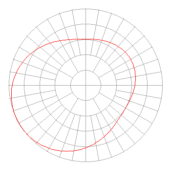
| Antenna Data for Antenna Id: 45963 WUTR DT File: BLCDT-20040217ADC Andrew - ALP16L2-HSOC-30 Service: DT Standard Pattern: Y Pattern and Field Values Include a 240° Clockwise Rotation |  | |||||||||||||||||||||||||||
| Azimuth | Ratio | Azimuth | Ratio | Azimuth | Ratio | Azimuth | Ratio | |||||||||||||||||||||
| 0 | 0.602 | 10 | 0.608 | 20 | 0.623 | 30 | 0.642 | |||||||||||||||||||||
| 40 | 0.659 | 50 | 0.672 | 60 | 0.676 | 70 | 0.672 | |||||||||||||||||||||
| 80 | 0.659 | 90 | 0.642 | 100 | 0.623 | 110 | 0.608 | |||||||||||||||||||||
| 120 | 0.602 | 130 | 0.609 | 140 | 0.631 | 150 | 0.668 | |||||||||||||||||||||
| 160 | 0.715 | 170 | 0.767 | 180 | 0.820 | 190 | 0.871 | |||||||||||||||||||||
| 200 | 0.915 | 210 | 0.951 | 220 | 0.978 | 230 | 0.994 | |||||||||||||||||||||
| 240 | 1.000 | 250 | 0.994 | 260 | 0.978 | 270 | 0.951 | |||||||||||||||||||||
| 280 | 0.915 | 290 | 0.871 | 300 | 0.820 | 310 | 0.767 | |||||||||||||||||||||
| 320 | 0.715 | 330 | 0.668 | 340 | 0.631 | 350 | 0.609 | |||||||||||||||||||||
Structure Registration Number 1003764 Structure Type: GTOWER Registered To: Mission Broadcasting, Inc. Structure Address: Atop Smith Hill Rd Approx 2 Mi Ne Utica, NY County Name: Oneida County ASR Issued: 03/09/2015 Date Built: 03/11/2015 Site Elevation: 371.8 m (1220 ft.) Structure Height: 113.6 m (373 ft.) Height Overall: 130.7 m (429 ft.) Overall Height AMSL: 502.5 m (1649 ft.) FAA Determination: 01/30/2015 FAA Study #: 2015-AEA-291-OE Paint & Light FAA Chapters: 1, 3, 12, 21 Continue As Is OM&L = PAINT/RED LIGHTS 43-08-41.1 N 75-10-32.2 W (NAD 83) 43-08-40.8 N 75-10-33.6 W (Converted to NAD 27) |
4822 Kemp Boulevard Suite 300 Wichita Falls, TX 76308 Phone: 940-228-7861 Corporation | Date: 02/17/2004 Application Certifier Central NY News, Inc. 2625 S. Memorial Drive Suite B Tulsa, OK 74129 Applicant John King 5904 Bridge Street Syracuse, NY 13057 Director of Engineering John Burgett Wiley Rein & Fielding LLP 1776 K Street, NW Washington, DC 20006 | ||||||||||||||||||||||||||
|
| |||||||||||||||||||||||||||