
FCCInfo.com
A Service of Cavell, Mertz & Associates, Inc.
(855) FCC-INFO
|
|
WKVC from 01/19/1997 WKVC from 05/10/1996 |
|
|
||||||||||||||||
|
|
WKVC Channel: 205C1 88.9 MHz North Myrtle Beach, South Carolina Service: FM - A full-service FM station or application. Facility ID: 14226 Fac. Service: FM Status: License Application Accepted: 12/09/2014 Application Granted: 12/22/2014 File Number: BLED-20141209ABG License Expires: 00/00/0000 Prefix Type: This is a license for a noncommercial educational FM station Application Type: License To Cover FCC Website Links: LMS Facility Details This Application CDBS Application Other WKVC Applications Other WKVC Applications in CDBS Including Superseded Applications Mailing Address Correspondence for WKVC Correspondence related to application BLED-20141209ABG Service Contour - Open Street Map or USGS Map (60 dBu) Service Contour - KML / Google Earth (60 dBu) Public Inspection Files Facility Type: NON-COMMERCIAL EDUC. FM Class: C1, A Zone II station; with 50kW-100kW ERP and a class contour distance 52km-72km Site Location: 34-05-41.6 N 78-28-26.0 W (NAD 83) Site Location: 34-05-41.0 N 78-28-27.0 W (Converted to NAD 27) Effective Radiated Power: 100 kW Transmitter Output Power: 19.98 kW Antenna Center HAAT: 174 m (571 ft.) Antenna Center AMSL: 186 m (610 ft.) Antenna Center HAG: 170 m (558 ft.) Calculated Site Elevation: 16 m. (52 ft.) Height Overall*: 181 m (594 ft.) (* As Filed In This Application, may differ from ASR Data, Below.) Directional Antenna Antenna Make/Model: Electronics Research Inc. MP-6E-DA, six sections Antenna ID: 114240 Polarization:
| ||||||||||||||||||
| Antenna Data for Antenna Id: 114240 WKVC FM File: BLED-20141209ABG Electronics Research Inc. - MP-6E-DA, six sections Service: FM | 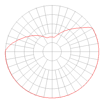 | ||||||||||||||||||
| Azimuth | Ratio | Azimuth | Ratio | Azimuth | Ratio | Azimuth | Ratio | ||||||||||||
| 0 | 0.317 | 10 | 0.317 | 20 | 0.398 | 30 | 0.502 | ||||||||||||
| 40 | 0.631 | 50 | 0.794 | 60 | 1.000 | 70 | 1.000 | ||||||||||||
| 80 | 1.000 | 90 | 1.000 | 100 | 1.000 | 110 | 1.000 | ||||||||||||
| 120 | 1.000 | 130 | 1.000 | 140 | 1.000 | 150 | 1.000 | ||||||||||||
| 160 | 1.000 | 170 | 1.000 | 180 | 1.000 | 190 | 1.000 | ||||||||||||
| 200 | 1.000 | 210 | 1.000 | 220 | 1.000 | 230 | 1.000 | ||||||||||||
| 240 | 1.000 | 250 | 1.000 | 260 | 1.000 | 270 | 1.000 | ||||||||||||
| 280 | 0.891 | 290 | 0.750 | 300 | 0.631 | 310 | 0.531 | ||||||||||||
| 320 | 0.447 | 330 | 0.376 | 340 | 0.317 | 350 | 0.317 | ||||||||||||
Structure Registration Number 1061810 Structure Type: TOWER Registered To: Educational Media Foundation Structure Address: Alligator Rd 2 Mi Sw Exum, NC County Name: Brunswick County ASR Issued: 12/11/2007 Date Built: 09/19/1997 Site Elevation: 16.4 m (54 ft.) Structure Height: 181 m (594 ft.) Height Overall: 181 m (594 ft.) Overall Height AMSL: 197.4 m (648 ft.) FAA Determination: 01/05/1996 FAA Study #: 95-ASO-3415-OE FAA Circular #: 70/7460-1J Paint & Light FAA Chapters: 4, 5, 7, 9, 13 34-05-41.6 N 78-28-26.0 W (NAD 83) 34-05-41.0 N 78-28-27.0 W (Converted to NAD 27) |
5700 West Oaks Boulevard Rocklin, CA 95765 Phone: 916-251-1600 Not-for-Profit | Date: 12/09/2014 Application Certifier EDUCATIONAL MEDIA FOUNDATION 5700 West Oaks Blvd Rocklin, CA 95765 Applicant STEPHEN WILDE 5700 West Oaks Blvd Rocklin, CA 95765 BROADCAST ENGINEER MARY N. O'CONNOR Wilkinson Barker Knauer, Llp | |||||||||||||||||