
FCCInfo.com
A Service of Cavell, Mertz & Associates, Inc.
(855) FCC-INFO
|
|
W275BH from 12/30/2008 W275BH from 02/05/2008 |
|
|
||||||||||||||||
|
|
W275BH Channel: 275D 102.9 MHz Lawrence, Massachusetts Service: FX - A translator or application for a translator. Facility ID: 155444 Fac. Service: FX Programming Delivery Method: Unspecified Status: License Application Accepted: 11/07/2019 Application Granted: 01/27/2020 File Number: -0000088390 License Expires: 04/01/2022 Application Type: License To Cover FCC Website Links: LMS Facility Details This Application Other W275BH Applications Other W275BH Applications in CDBS Including Superseded Applications Mailing Address Correspondence for W275BH Correspondence related to application -0000088390 Service Contour - Open Street Map or USGS Map (60 dBu) Service Contour - KML / Google Earth (60 dBu) Facility Type: FM STATION Class: D, A Noncommercial educational operating with no more than 10W Site Location: 42-40-26.3 N 71-11-24.2 W (NAD 83) Site Location: 42-40-26.0 N 71-11-26.0 W (Converted to NAD 27) Effective Radiated Power: 0.215 kW Antenna Center HAAT: 0 m Antenna Center AMSL: 177 m (581 ft.) Antenna Center HAG: 116 m (381 ft.) Site Elevation: 61 m. (200 ft.) Height Overall*: 123 m (404 ft.) (* As Filed In This Application, may differ from ASR Data, Below.) Directional Antenna Antenna Make/Model: Nicom BKY3/P-3DA(SLANT45)(0.85WL) Antenna ID: 134672 Polarization: H
| ||||||||||||||||||
| Antenna Data for Antenna Id: 134672 W275BH FX File: -0000088390 Nicom - BKY3/P-3DA(SLANT45)(0.85WL) Service: FX | 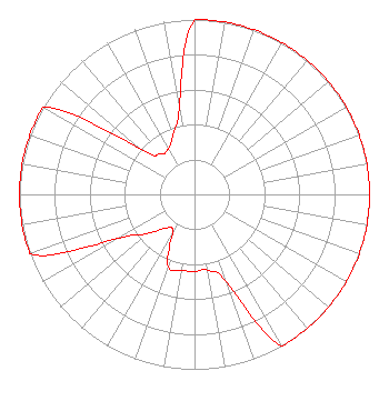 | ||||||||||||||||||
| Azimuth | Ratio | Azimuth | Ratio | Azimuth | Ratio | Azimuth | Ratio | ||||||||||||
| 0 | 1.000 | 10 | 1.000 | 20 | 1.000 | 30 | 1.000 | ||||||||||||
| 40 | 1.000 | 50 | 1.000 | 60 | 1.000 | 70 | 1.000 | ||||||||||||
| 80 | 1.000 | 90 | 1.000 | 100 | 1.000 | 110 | 1.000 | ||||||||||||
| 120 | 1.000 | 130 | 1.000 | 140 | 1.000 | 150 | 1.000 | ||||||||||||
| 160 | 0.530 | 170 | 0.440 | 180 | 0.440 | 190 | 0.440 | ||||||||||||
| 200 | 0.440 | 210 | 0.250 | 220 | 0.250 | 230 | 0.350 | ||||||||||||
| 240 | 0.500 | 250 | 1.000 | 260 | 1.000 | 270 | 1.000 | ||||||||||||
| 280 | 1.000 | 290 | 1.000 | 300 | 1.000 | 310 | 0.400 | ||||||||||||
| 320 | 0.300 | 330 | 0.300 | 340 | 0.360 | 350 | 0.500 | ||||||||||||
Structure Registration Number 1005780 Structure Type: TOWER Registered To: K2 Towers II, LLC Structure Address: 119 Chandler Rd Andover, MA County Name: Essex County ASR Issued: 12/24/2019 Date Built: 08/01/1972 Site Elevation: 60.9 m (200 ft.) Structure Height: 121.9 m (400 ft.) Height Overall: 122.8 m (403 ft.) Overall Height AMSL: 183.7 m (603 ft.) Paint & Light FAA Chapters: 1, 3, 12, 21 42-40-26.0 N 71-11-24.0 W (NAD 83) 42-40-25.7 N 71-11-25.8 W (Converted to NAD 27) |
462 Merrimack Street Methuen, MA 01844 Phone: 978-686-9966 Limited Partnership | Title: General Partner Date: 11/07/2019 Application Certifier COSTA-EAGLE RADIO VENTURES LIMITED PARTNERSHIP Costa-eagle Radio Ventures Limited Partnership 462 Merrimack Street Methuen, MA 01844 Applicant Aaron P Shainis Shainis & Peltzman, Chartered 1850 M St. Nw Suite 240 Washington, DC 20036 FCC Legal Counsel Justin Asher Asher Broadcast Consulting, Llc 579 Babcock Road Bronson, MI 49028-9347 Technical Consultant | |||||||||||||||||