
FCCInfo.com
A Service of Cavell, Mertz & Associates, Inc.
(855) FCC-INFO
|
|
WRIH from 08/06/1997 |
|  |
|
|||||||||||||||
|
|
WRIH Channel: 201B1 88.1 MHz Richmond, Virginia Service: FM - A full-service FM station or application. Facility ID: 87808 Fac. Service: FM Status: License Application Accepted: 01/17/2020 Application Granted: 01/24/2020 File Number: -0000098058 License Expires: 10/01/2027 Application Type: License To Cover FCC Website Links: LMS Facility Details This Application Other WRIH Applications Other WRIH Applications in CDBS Including Superseded Applications Mailing Address Correspondence for WRIH Correspondence related to application -0000098058 Service Contour - Open Street Map or USGS Map (60 dBu) Service Contour - KML / Google Earth (60 dBu) Public Inspection Files Facility Type: NON-COMMERCIAL EDUC. FM Class: B1, A Zone I or I-A station; with 6kW-25kW ERP and a class contour distance 28km-39km Site Location: 37-42-54.4 N 77-21-54.0 W (NAD 83) Site Location: 37-42-53.9 N 77-21-55.1 W (Converted to NAD 27) Effective Radiated Power: 5 kW Transmitter Output Power: 1.056 kW Antenna Center HAAT: 146 m (479 ft.) Antenna Center AMSL: 189 m (620 ft.) Antenna Center HAG: 131 m (430 ft.) Site Elevation: 57.9 m. (190 ft.) Height Overall*: 138.4 m (454 ft.) (* As Filed In This Application, may differ from ASR Data, Below.) Directional Antenna Antenna Make/Model: Shivley 6513 Antenna ID: 83602 Polarization: | ||||||||||||||||||
| Antenna Data for Antenna Id: 83602 WRIH FM File: -0000098058 Shivley - 6513 Service: FM | 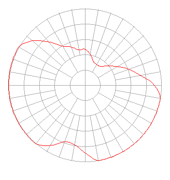 | ||||||||||||||||||
| Azimuth | Ratio | Azimuth | Ratio | Azimuth | Ratio | Azimuth | Ratio | ||||||||||||
| 0 | 0.468 | 10 | 0.403 | 20 | 0.324 | 30 | 0.310 | ||||||||||||
| 40 | 0.320 | 50 | 0.389 | 60 | 0.486 | 70 | 0.610 | ||||||||||||
| 80 | 0.734 | 90 | 0.907 | 100 | 1.000 | 110 | 1.000 | ||||||||||||
| 120 | 1.000 | 130 | 1.000 | 140 | 1.000 | 150 | 1.000 | ||||||||||||
| 160 | 1.000 | 170 | 1.000 | 180 | 0.883 | 190 | 0.787 | ||||||||||||
| 200 | 0.787 | 210 | 0.909 | 220 | 1.000 | 230 | 1.000 | ||||||||||||
| 240 | 1.000 | 250 | 1.000 | 260 | 1.000 | 270 | 1.000 | ||||||||||||
| 280 | 1.000 | 290 | 1.000 | 300 | 1.000 | 310 | 0.899 | ||||||||||||
| 320 | 0.736 | 330 | 0.589 | 340 | 0.530 | 350 | 0.466 | ||||||||||||
Structure Registration Number 1266597 Structure Type: LTOWER Registered To: Hanover County Structure Address: 11375 Georgetown Road Hanover, VA County Name: Hanover County ASR Issued: 12/19/2017 Date Built: 05/06/2009 Site Elevation: 57.9 m (190 ft.) Structure Height: 137 m (449 ft.) Height Overall: 138.4 m (454 ft.) Overall Height AMSL: 196.3 m (644 ft.) FAA Determination: 01/08/2010 FAA Study #: 2009-AEA-3919-OE FAA Circular #: 70/7460-1K Paint & Light FAA Chapters: 4, 8, 12 OM&L to remain the same as prior study = A MED-DUAL SYSTEM 37-42-54.4 N 77-21-54.0 W (NAD 83) 37-42-53.9 N 77-21-55.1 W (Converted to NAD 27) |
Po Drawer 2440 Tupelo, MS 38801-2440 Phone: 662-844-8888 Not-for-Profit | Title: President Date: 01/17/2020 Application Certifier AMERICAN FAMILY ASSOCIATION American Family Association Po Drawer 2440 Tupelo, MS 38803 Applicant Jessica Huckaby American Family Association Po Drawer 2440 Tupelo, MS 38803 Technical Consultant | |||||||||||||||||