
FCCInfo.com
A Service of Cavell, Mertz & Associates, Inc.
(855) FCC-INFO
|
|
|
|
|
||||||||||||||||
|
|
W280EP Channel: 280D 103.9 MHz Lumberton, North Carolina Service: FX - A translator or application for a translator. Facility ID: 156774 Fac. Service: FX Programming Delivery Method: Unspecified Status: License Application Accepted: 08/13/2020 Application Granted: 08/14/2020 File Number: -0000120371 License Expires: 12/01/2027 Application Type: License To Cover FCC Website Links: LMS Facility Details This Application Other W280EP Applications Other W280EP Applications in CDBS Including Superseded Applications Mailing Address Correspondence for W280EP Correspondence related to application -0000120371 Service Contour - Open Street Map or USGS Map (60 dBu) Service Contour - KML / Google Earth (60 dBu) Facility Type: NON-COMMERCIAL EDUC. FM Class: D, A Noncommercial educational operating with no more than 10W Site Location: 34-35-47.1 N 79-00-35.7 W (NAD 83) Site Location: 34-35-46.5 N 79-00-36.6 W (Converted to NAD 27) Effective Radiated Power: 0.038 kW Transmitter Output Power: 0.311 kW Antenna Center HAAT: 0 m Antenna Center AMSL: 114.6 m (376 ft.) Antenna Center HAG: 79.9 m (262 ft.) Site Elevation: 34.7 m. (114 ft.) Height Overall*: 93.3 m (306 ft.) (* As Filed In This Application, may differ from ASR Data, Below.) Directional Antenna Antenna Make/Model: Nicom BKG77/1L(DA) Antenna ID: 133089 Polarization: H
| ||||||||||||||||||
| Antenna Data for Antenna Id: 133089 W280EP FX File: -0000120371 Nicom - BKG77/1L(DA) Service: FX | 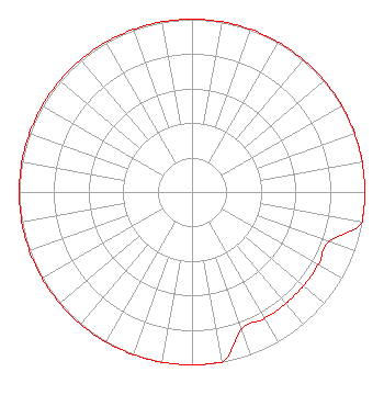 | ||||||||||||||||||
| Azimuth | Ratio | Azimuth | Ratio | Azimuth | Ratio | Azimuth | Ratio | ||||||||||||
| 0 | 1.000 | 10 | 1.000 | 20 | 1.000 | 30 | 1.000 | ||||||||||||
| 40 | 1.000 | 50 | 1.000 | 60 | 1.000 | 70 | 1.000 | ||||||||||||
| 80 | 1.000 | 90 | 1.000 | 100 | 1.000 | 110 | 0.843 | ||||||||||||
| 120 | 0.843 | 130 | 0.843 | 140 | 0.843 | 150 | 0.843 | ||||||||||||
| 160 | 0.843 | 170 | 1.000 | 180 | 1.000 | 190 | 1.000 | ||||||||||||
| 200 | 1.000 | 210 | 1.000 | 220 | 1.000 | 230 | 1.000 | ||||||||||||
| 240 | 1.000 | 250 | 1.000 | 260 | 1.000 | 270 | 1.000 | ||||||||||||
| 280 | 1.000 | 290 | 1.000 | 300 | 1.000 | 310 | 1.000 | ||||||||||||
| 320 | 1.000 | 330 | 1.000 | 340 | 1.000 | 350 | 1.000 | ||||||||||||
Structure Registration Number 1020469 Structure Type: TOWER Registered To: Educational Media Foundation Structure Address: 1498 Alamac Road Lumberton, NC County Name: Robeson County ASR Issued: 09/25/2012 Date Built: 01/01/1965 Site Elevation: 34.7 m (114 ft.) Structure Height: 92.4 m (303 ft.) Height Overall: 93.3 m (306 ft.) Overall Height AMSL: 128 m (420 ft.) FAA Determination: 07/15/2011 FAA Study #: 2011-ASO-4329-OE FAA Circular #: 70/7460-1K Paint & Light FAA Chapters: 3, 4, 5, 12 34-35-47.1 N 79-00-35.7 W (NAD 83) 34-35-46.5 N 79-00-36.6 W (Converted to NAD 27) |
11530 Carmel Commons Blvd. Charlotte, NC 28226 Phone: 704-523-5555 Not-for-Profit | Title: Secretary-treasurer Date: 08/13/2020 Application Certifier BIBLE BROADCASTING NETWORK, INC. Bible Broadcasting Network, Inc. 11530 Carmel Commons Blvd. Charlotte, NC 28226 Applicant Justin Asher Asher Broadcast Consulting, Llc 579 Babcock Road Bronson, MI 49028 Technical Consultant GARY S. SMITHWICK, ESQ Smithwick & Belendiuk, P.c. 5028 Wisconsin Avenue, Nw Suite 301 Washington, WA 20016 Legal Counsel | |||||||||||||||||