|
WKVO(FM)
Call Sign History
WKVO from 03/26/2004
WRVG-FM from 03/28/1983
WRVG from ???
|
89.9 MHz
|
Georgetown, KY
|
|
WKVO Channel: 210C2 89.9 MHz
Georgetown, Kentucky
Service: FM - A full-service FM station or application.
Facility ID: 23901
FRN: 0004121000
Fac. Service: FM
Status: LIC
Application Accepted: 05/11/1998
Application Granted: 12/21/2000
File Number: BLED-19980511KA
License Expires: 08/01/2028
Prefix Type: This is a license for a noncommercial educational FM station
Application Type: License To Cover
FCC Website Links:
LMS Facility Details
This Application
Other WKVO Applications
Including Superseded Applications
Service Contour - Open Street Map or USGS Map (60 dBu)
Service Contour - KML / Google Earth (60 dBu)
Public Inspection Files
Facility Type: NON-COMMERCIAL EDUC. FM
Class: C2, A Zone II station; with 25kW-50kW ERP and a class contour distance 39km-52km
Site Location: 38-12-15.3 N 84-32-50.8 W (NAD 83)
Site Location: 38-12-15.0 N 84-32-51.0 W (Converted to NAD 27)
Effective Radiated Power: 50 kW
Transmitter Output Power: 13.5 kW
Antenna Center HAAT: 125 m (410 ft.)
Antenna Center AMSL: 394 m (1293 ft.)
Antenna Center HAG: 121 m (397 ft.)
Calculated Site Elevation: 273 m. (896 ft.)
Height Overall*: 131 m (430 ft.)
(* As Filed In This Application, may differ from ASR Data, Below.)
Directional Antenna
Antenna Make/Model: Oddball; usually designed by Applicant ODD960709MB
Antenna ID: 15023
Polarization:
|
Antenna Data for Antenna Id: 15023
WKVO FM File: BLED-19980511KA
Oddball; usually designed by Applicant - ODD960709MB
Service: FM
|
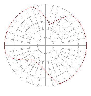 |
| Azimuth | Ratio | Azimuth | Ratio | Azimuth | Ratio | Azimuth | Ratio |
| 0 | 0.680 | 10 | 0.540 | 12 | 0.530 | 20 | 0.610 |
| 30 | 0.760 | 40 | 0.950 | 50 | 1.000 | 60 | 1.000 |
| 70 | 1.000 | 80 | 1.000 | 90 | 1.000 | 100 | 1.000 |
| 110 | 1.000 | 120 | 1.000 | 130 | 1.000 | 140 | 1.000 |
| 150 | 1.000 | 160 | 0.990 | 170 | 0.790 | 180 | 0.630 |
| 190 | 0.540 | 200 | 0.490 | 210 | 0.470 | 220 | 0.470 |
| 225 | 0.500 | 230 | 0.560 | 240 | 0.700 | 250 | 0.880 |
| 260 | 1.000 | 270 | 1.000 | 280 | 1.000 | 290 | 1.000 |
| 300 | 1.000 | 310 | 1.000 | 320 | 1.000 | 330 | 1.000 |
| 340 | 1.000 | 350 | 0.850 |
Structure Information
Structure Registration Number 1020866
[ASR Heights Differ from WKVO Application]
Structure Type: GTOWER
Registered To:
American Towers LLC
Structure Address:
700 Lemons Mill Rd (#278108)
Georgetown, KY
County Name: Scott County
ASR Issued: 09/30/2024
Date Built: 05/07/1998
Site Elevation: 272.8 m (895 ft.)
Structure Height: 108.5 m (356 ft.)
Height Overall: 132.9 m (436 ft.)
Overall Height AMSL: 405.7 m (1331 ft.)
FAA Determination: 09/10/2024
FAA Study #: 2024-ASO-14253-OE
FAA Circular #: 70/7460-1L
Paint & Light FAA Chapters: 4, 8, 12
OM&L to remain the same as prior studies = A MED-DUAL SYSTEM
38-12-15.3 N 84-32-50.8 W (NAD 83)
38-12-15.0 N 84-32-51.0 W
(Converted to NAD 27)
|
WKVO(FM) Licensee Information
Educational Media Foundation
5700 West Oaks Blvd
Rocklin, CA 95765
Phone: 916-251-1600
Not-for-Profit | 19980511KA Applicant Information
Date: 05/11/1998
Application Certifier
Georgetown College
Georgetown College, Inc.
400 E College St
Georgetown, KY 40324
Applicant
|
Associated Land Mobile Licenses
|
| (No Records Found) |
| Associated Microwave Licenses
|
| (No Records Found) |
|
