
FCCInfo.com
A Service of Cavell, Mertz & Associates, Inc.
(855) FCC-INFO
|
|
K222BH from 12/09/1996 |
|
|
||||||||||||||||
|
|
K222BH Channel: 222D 92.3 MHz St. Joseph, Missouri Service: FX - A translator or application for a translator. Facility ID: 78965 Fac. Service: FX Programming Delivery Method: Unspecified Status: License Application Accepted: 03/15/2006 Application Granted: 04/20/2006 File Number: BLFT-20060315ABV License Expires: 02/01/2029 Prefix Type: This is a license for a translator Application Type: License To Cover FCC Website Links: LMS Facility Details This Application CDBS Application Other K222BH Applications Other K222BH Applications in CDBS Including Superseded Applications Mailing Address Correspondence for K222BH Correspondence related to application BLFT-20060315ABV Service Contour - Open Street Map or USGS Map (60 dBu) Service Contour - KML / Google Earth (60 dBu) Class: D, A Noncommercial educational operating with no more than 10W Site Location: 39-44-04.0 N 94-47-23.9 W (NAD 83) Site Location: 39-44-04.0 N 94-47-23.0 W (Converted to NAD 27) Effective Radiated Power: 0 kW Horiz. ; 0.015 kW Vert. Transmitter Output Power: 0.015 kW Antenna Center HAAT: 0 m Horiz.; 70.6 m Vert. Antenna Center AMSL: 0 m Horiz.; 347 m Vert. Antenna Center HAG: 0 m Horiz.; 35 m Vert. Site Elevation: 312 m. (1024 ft.) Height Overall*: 106 m (348 ft.) (* As Filed In This Application, may differ from ASR Data, Below.) Directional Antenna Antenna Make/Model: Telrex ANT90-V Antenna ID: 71137 Polarization: H
| ||||||||||||||||||
| Antenna Data for Antenna Id: 71137 K222BH FX File: BLFT-20060315ABV Telrex - ANT90-V Service: FX Pattern and Field Values Include a 270° Clockwise Rotation | 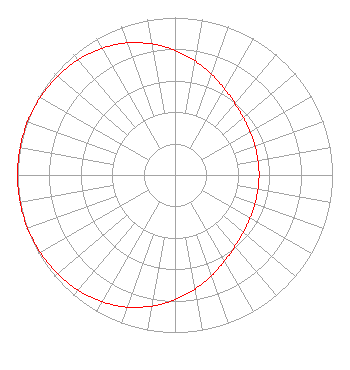 | ||||||||||||||||||
| Azimuth | Ratio | Azimuth | Ratio | Azimuth | Ratio | Azimuth | Ratio | ||||||||||||
| 0 | 0.792 | 10 | 0.735 | 20 | 0.679 | 30 | 0.630 | ||||||||||||
| 40 | 0.592 | 50 | 0.566 | 60 | 0.549 | 70 | 0.540 | ||||||||||||
| 80 | 0.535 | 90 | 0.534 | 100 | 0.535 | 110 | 0.540 | ||||||||||||
| 120 | 0.549 | 130 | 0.566 | 140 | 0.592 | 150 | 0.630 | ||||||||||||
| 160 | 0.679 | 170 | 0.735 | 180 | 0.792 | 190 | 0.845 | ||||||||||||
| 200 | 0.892 | 210 | 0.929 | 220 | 0.956 | 230 | 0.975 | ||||||||||||
| 240 | 0.987 | 250 | 0.995 | 260 | 0.999 | 270 | 1.000 | ||||||||||||
| 280 | 0.999 | 290 | 0.995 | 300 | 0.987 | 310 | 0.975 | ||||||||||||
| 320 | 0.956 | 330 | 0.929 | 340 | 0.892 | 350 | 0.845 | ||||||||||||
Structure Registration Number 1246670 [ASR Heights Differ from K222BH Application] Structure Type: GTOWER Registered To: Midwest Mobile Radio Service Structure Address: 3011 S. 42nd Street St. Joseph, MO County Name: Buchanan County ASR Issued: 03/17/2017 Date Built: 02/01/2005 Site Elevation: 318.5 m (1045 ft.) Structure Height: 100.5 m (330 ft.) Height Overall: 106 m (348 ft.) Overall Height AMSL: 424.5 m (1393 ft.) FAA Determination: 03/16/2017 FAA Study #: 2017-ACE-1117-OE FAA Circular #: 70/7460-1K Paint & Light FAA Chapters: 4, 8, 12 PRIOR STUDY 2004-ACE-2340-OE 39-44-03.5 N 94-47-23.9 W (NAD 83) 39-44-03.5 N 94-47-23.0 W (Converted to NAD 27) |
4002 N. 3300 E. Twin Falls, ID 83303 Phone: 208-734-6633 Not-for-Profit | Date: 03/15/2006 Application Certifier CALVARY CHAPEL OF TWIN FALLS, INC. 4002 N. 3300 E. Twin Falls, ID 83301 Applicant CARY TEPPER Booth, Freret, Imlay & Tepper, P.c. 7900 Wisconsin Ave, Suite 304 Bethesda, MD 20814 LOIS MILLS Po Box 391 Twin Falls, ID 83303 APPLICATIONS TECHNICIAN | |||||||||||||||||