
FCCInfo.com
A Service of Cavell, Mertz & Associates, Inc.
(855) FCC-INFO
|
|
WYVM from 02/15/2012 WYVM from 08/10/2010 |
|  |
|
|||||||||||||||
|
|
WYVM Channel: 215C3 90.9 MHz Sheboygan, Wisconsin Service: FM - A full-service FM station or application. Facility ID: 176342 Fac. Service: FM Status: License Application Accepted: 11/05/2012 Application Granted: 01/04/2013 File Number: BLED-20121105ABV License Expires: 00/00/0000 Prefix Type: This is a license for a noncommercial educational FM station Application Type: License To Cover FCC Website Links: LMS Facility Details This Application CDBS Application Other WYVM Applications Other WYVM Applications in CDBS Including Superseded Applications Mailing Address Correspondence for WYVM Correspondence related to application BLED-20121105ABV Service Contour - Open Street Map or USGS Map (60 dBu) Service Contour - KML / Google Earth (60 dBu) Public Inspection Files Facility Type: NON-COMMERCIAL EDUC. FM Class: C3, A Zone II station; with 6kW-25kW ERP and a class contour distance 28km-39km Site Location: 43-51-42.1 N 87-46-20.8 W (NAD 83) Site Location: 43-51-42.1 N 87-46-20.5 W (Converted to NAD 27) Effective Radiated Power: 0 kW Horiz. ; 6.1 kW Vert. Transmitter Output Power: 4 kW Antenna Center HAAT: 0 m Horiz.; 40 m Vert. Antenna Center AMSL: 0 m Horiz.; 251 m Vert. Antenna Center HAG: 0 m Horiz.; 44 m Vert. Calculated Site Elevation: m. Height Overall*: 61.3 m (201 ft.) (* As Filed In This Application, may differ from ASR Data, Below.) Directional Antenna Antenna Make/Model: Propagation System Inc PSI FMLV-1-DA Antenna ID: 109882 Polarization:
| ||||||||||||||||||
| Antenna Data for Antenna Id: 109882 WYVM FM File: BLED-20121105ABV Propagation System Inc - PSI FMLV-1-DA Service: FM | 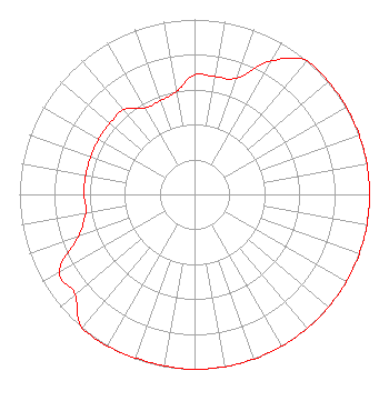 | ||||||||||||||||||
| Azimuth | Ratio | Azimuth | Ratio | Azimuth | Ratio | Azimuth | Ratio | ||||||||||||
| 0 | 0.684 | 10 | 0.684 | 20 | 0.708 | 30 | 0.881 | ||||||||||||
| 40 | 1.000 | 50 | 1.000 | 60 | 1.000 | 70 | 1.000 | ||||||||||||
| 80 | 1.000 | 90 | 1.000 | 100 | 1.000 | 110 | 1.000 | ||||||||||||
| 120 | 1.000 | 130 | 1.000 | 140 | 1.000 | 150 | 1.000 | ||||||||||||
| 160 | 1.000 | 170 | 1.000 | 180 | 1.000 | 190 | 0.994 | ||||||||||||
| 200 | 0.994 | 210 | 1.000 | 220 | 1.000 | 230 | 0.891 | ||||||||||||
| 240 | 0.891 | 250 | 0.708 | 260 | 0.631 | 270 | 0.631 | ||||||||||||
| 280 | 0.631 | 290 | 0.631 | 300 | 0.631 | 310 | 0.631 | ||||||||||||
| 320 | 0.631 | 330 | 0.570 | 340 | 0.570 | 350 | 0.596 | ||||||||||||
Structure Registration Number 1228043 [ASR Heights Differ from WYVM Application] Structure Type: LTOWER Registered To: SBA Structures, LLC Structure Address: W1545 County Road Mm (wi21185-a) Cleveland, WI County Name: Sheboygan County ASR Issued: 03/05/2018 Date Built: 07/27/2001 Site Elevation: 206.7 m (678 ft.) Structure Height: 59.4 m (195 ft.) Height Overall: 61.3 m (201 ft.) Overall Height AMSL: 268 m (879 ft.) FAA Determination: 01/05/2018 FAA Study #: 2018-AGL-313-OE FAA Circular #: 70/7460-1L Paint & Light FAA Chapters: 4, 8, 12 PRIOR STUDY 2006-AGL-10015-OE 43-51-42.1 N 87-46-20.8 W (NAD 83) 43-51-42.1 N 87-46-20.5 W (Converted to NAD 27) |
P.o. Box 212 Suring, WI 54174-0212 Phone: 920-842-2900 | Date: 11/05/2012 Application Certifier WRVM, INC. Po Box 212 Suring, WI 54174 Applicant ALAN F KILGORE, CPBE Po Box 212 Suring, WI 54174-0212 CHIEF ENGINEER ALAN KILGORE Wrvm, Inc. | |||||||||||||||||