
FCCInfo.com
A Service of Cavell, Mertz & Associates, Inc.
(855) FCC-INFO
|
|
WWLW from 06/30/1996 WWLW from 09/02/1985 |
|
|
|||||||||||||||||||||||||
|
|
WWLW Channel: 293B 106.5 MHz Clarksburg, West Virginia Service: FM - A full-service FM station or application. Facility ID: 74163 Fac. Service: FM Status: License 73.215 Station Application Accepted: 02/26/2002 Application Granted: 04/11/2002 File Number: BLH-20020226AAR License Expires: 00/00/0000 Prefix Type: This is a license for a commercial FM station Application Type: Amendment FCC Website Links: LMS Facility Details This Application CDBS Application Other WWLW Applications Other WWLW Applications in CDBS Including Superseded Applications Mailing Address Correspondence for WWLW Correspondence related to application BLH-20020226AAR Service Contour - Open Street Map or USGS Map (54 dBu) Service Contour - KML / Google Earth (54 dBu) Public Inspection Files History Cards for WWLW Facility Type: FM STATION Class: B, A Zone I or I-A station; with 25kW-50kW ERP and a class contour distance 39km-52km Site Location: 39-15-44.3 N 80-28-00.3 W (NAD 83) Site Location: 39-15-44.0 N 80-28-01.0 W (Converted to NAD 27) Effective Radiated Power: 28 kW Transmitter Output Power: 10.34 kW Antenna Center HAAT: 199 m (653 ft.) Antenna Center AMSL: 560.2 m (1838 ft.) Antenna Center HAG: 74.7 m (245 ft.) Site Elevation: 485.5 m. (1593 ft.) Height Overall*: 83.9 m (275 ft.) (* As Filed In This Application, may differ from ASR Data, Below.) Directional Antenna Antenna Make/Model: DIELECTRIC SKM6CD.5 Antenna ID: 32730 Polarization: | |||||||||||||||||||||||||||
| Antenna Data for Antenna Id: 32730 WWLW FM File: BLH-20020226AAR DIELECTRIC - SKM6CD.5 Service: FM | 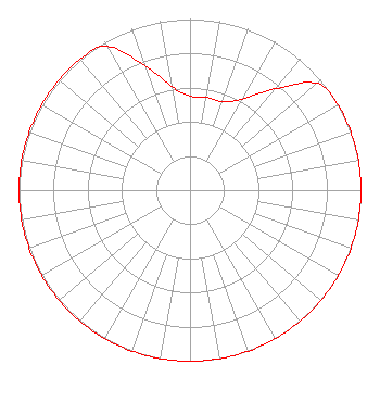 | |||||||||||||||||||||||||||
| Azimuth | Ratio | Azimuth | Ratio | Azimuth | Ratio | Azimuth | Ratio | |||||||||||||||||||||
| 0 | 0.550 | 10 | 0.550 | 20 | 0.550 | 30 | 0.615 | |||||||||||||||||||||
| 40 | 0.772 | 50 | 0.970 | 60 | 1.000 | 70 | 1.000 | |||||||||||||||||||||
| 80 | 1.000 | 90 | 1.000 | 100 | 1.000 | 110 | 1.000 | |||||||||||||||||||||
| 120 | 1.000 | 130 | 1.000 | 140 | 1.000 | 150 | 1.000 | |||||||||||||||||||||
| 160 | 1.000 | 170 | 1.000 | 180 | 1.000 | 190 | 1.000 | |||||||||||||||||||||
| 200 | 1.000 | 210 | 1.000 | 220 | 1.000 | 230 | 1.000 | |||||||||||||||||||||
| 240 | 1.000 | 250 | 1.000 | 260 | 1.000 | 270 | 1.000 | |||||||||||||||||||||
| 280 | 1.000 | 290 | 1.000 | 300 | 1.000 | 310 | 1.000 | |||||||||||||||||||||
| 320 | 1.000 | 330 | 0.970 | 340 | 0.772 | 350 | 0.615 | |||||||||||||||||||||
Structure Registration Number 1033948 Structure Type: TOWER Registered To: WEST VIRGINIA RADIO CORPORATION Structure Address: 1.8 Km South Of Route 50 Salem, WV County Name: Harrison County ASR Issued: 08/14/2000 Date Built: 06/01/2000 Site Elevation: 485.5 m (1593 ft.) Structure Height: 82.9 m (272 ft.) Height Overall: 83.8 m (275 ft.) Overall Height AMSL: 569.3 m (1868 ft.) FAA Determination: 05/25/2000 FAA Study #: 00-AEA-0348-OE FAA Circular #: 70/7460-1K Paint & Light FAA Chapters: 4, 8, 12 Removed expiration date from determination. Scenario 1./jjs/case#635066 39-15-44.0 N 80-28-00.0 W (NAD 83) 39-15-43.7 N 80-28-00.7 W (Converted to NAD 27) |
Greer Building 1251 Earl L. Core Road Morgantown, WV 26505 | Date: 02/26/2002 Application Certifier WEST VIRGINIA RADIO CORPORATION OF CLARKSBURG Greer Building 1251 Earl L. Core Road Morgantown, WV 26505-5896 Applicant CLARENCE M. BEVERAGE P.o. Box 1130 Marlton, NJ 08053 BROADCAST ENGINEERING CONSULTANT DAVID M. HUNSAKER Putbrese Hunsaker & Trent, Pc | ||||||||||||||||||||||||||
| ||||||||||||||||||||||||||||