
FCCInfo.com
A Service of Cavell, Mertz & Associates, Inc.
(855) FCC-INFO
|
|
|
|
|
||||||||||||||||
|
|
WLXP Channel: 201A 88.1 MHz Savannah, Georgia Service: FM - A full-service FM station or application. Facility ID: 81997 Fac. Service: FM Status: License Application Accepted: 11/09/2005 Application Granted: 04/24/2007 File Number: BLED-20051109ACD License Expires: 00/00/0000 Prefix Type: This is a license for a noncommercial educational FM station Application Type: License To Cover FCC Website Links: LMS Facility Details This Application CDBS Application Other WLXP Applications Other WLXP Applications in CDBS Including Superseded Applications Mailing Address Correspondence for WLXP Correspondence related to application BLED-20051109ACD Service Contour - Open Street Map or USGS Map (60 dBu) Service Contour - KML / Google Earth (60 dBu) Public Inspection Files Facility Type: NON-COMMERCIAL EDUC. FM Class: A, A Zone I; I-A; or II station; with 0.1kW-6kW ERP and a class contour distance <=28km Site Location: 32-03-48.8 N 81-02-55.4 W (NAD 83) Site Location: 32-03-48.0 N 81-02-56.0 W (Converted to NAD 27) Effective Radiated Power: 5.5 kW Transmitter Output Power: 2.352 kW Antenna Center HAAT: 104 m (341 ft.) Antenna Center AMSL: 105 m (344 ft.) Antenna Center HAG: 98.9 m (324 ft.) Site Elevation: 6.1 m. (20 ft.) Height Overall*: 109.7 m (360 ft.) (* As Filed In This Application, may differ from ASR Data, Below.) Directional Antenna Antenna Make/Model: Electronics Research Inc. LP-4E-DA-HW, 4 sections, 0.5 wavelength spacing Antenna ID: 64183 Polarization: | ||||||||||||||||||
| Antenna Data for Antenna Id: 64183 WLXP FM File: BLED-20051109ACD Electronics Research Inc. - LP-4E-DA-HW, 4 sections, 0.5 wavelength spacing Service: FM | 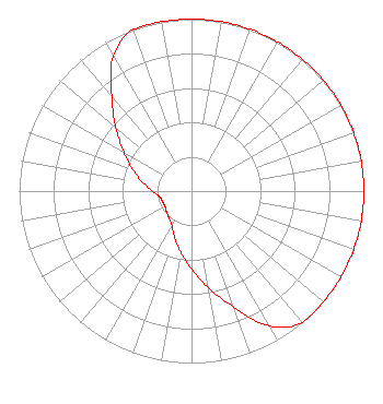 | ||||||||||||||||||
| Azimuth | Ratio | Azimuth | Ratio | Azimuth | Ratio | Azimuth | Ratio | ||||||||||||
| 0 | 1.000 | 10 | 1.000 | 20 | 1.000 | 30 | 1.000 | ||||||||||||
| 40 | 1.000 | 50 | 1.000 | 60 | 1.000 | 70 | 1.000 | ||||||||||||
| 80 | 1.000 | 90 | 1.000 | 100 | 1.000 | 110 | 1.000 | ||||||||||||
| 120 | 1.000 | 130 | 1.000 | 140 | 1.000 | 150 | 0.906 | ||||||||||||
| 160 | 0.720 | 170 | 0.572 | 180 | 0.454 | 190 | 0.361 | ||||||||||||
| 200 | 0.287 | 210 | 0.228 | 220 | 0.203 | 230 | 0.189 | ||||||||||||
| 240 | 0.178 | 250 | 0.178 | 260 | 0.189 | 270 | 0.228 | ||||||||||||
| 280 | 0.287 | 290 | 0.361 | 300 | 0.454 | 310 | 0.572 | ||||||||||||
| 320 | 0.720 | 330 | 0.906 | 340 | 1.000 | 350 | 1.000 | ||||||||||||
Structure Registration Number 1021799 Structure Type: LTOWER Registered To: American Towers LLC Structure Address: 2625 Gregory Street (gregory - 100022254) Savannah, GA County Name: Chatham County ASR Issued: 12/09/2016 Date Built: 03/18/2009 Site Elevation: 6.1 m (20 ft.) Structure Height: 106.7 m (350 ft.) Height Overall: 109.7 m (360 ft.) Overall Height AMSL: 115.8 m (380 ft.) FAA Determination: 04/30/2015 FAA Study #: 2015-ASO-3276-OE FAA Circular #: 70/7460-1K Paint & Light FAA Chapters: 4, 8, 12 PRIOR STUDY 2009-ASO-1592-OE 32-03-48.7 N 81-02-55.4 W (NAD 83) 32-03-47.9 N 81-02-56.0 W (Converted to NAD 27) |
141 Pearl Street Se Atlanta, GA 30316 Not-for-Profit | Date: 11/09/2005 Application Certifier CHRISTIAN MULTIMEDIA NETWORK, INC. 230 Waterford Falls Dr. Canton, GA 30114 Applicant SAM WALLINGTON 5700 West Oaks Blvd Rocklin, CA 95765 CONSULTING ENGINEER GARY KELLER Christian Multimedia Network, Inc. | |||||||||||||||||