
FCCInfo.com
A Service of Cavell, Mertz & Associates, Inc.
(855) FCC-INFO
|
|
|
|
|
||||||||||||||||
|
|
WQFL Channel: 265A 100.9 MHz Rockford, Illinois Service: FM - A full-service FM station or application. Facility ID: 54255 Fac. Service: FM Status: License 73.215 Station Application Accepted: 04/21/2011 Application Granted: 05/11/2011 File Number: BMLED-20110421ABV License Expires: 00/00/0000 Prefix Type: This is a modification of license for a noncommercial educational FM station Application Type: Minor Modification FCC Website Links: LMS Facility Details This Application CDBS Application Other WQFL Applications Other WQFL Applications in CDBS Including Superseded Applications Mailing Address Correspondence for WQFL Correspondence related to application BMLED-20110421ABV Service Contour - Open Street Map or USGS Map (60 dBu) Service Contour - KML / Google Earth (60 dBu) Public Inspection Files History Cards for WQFL Facility Type: NON-COMMERCIAL EDUC. FM Class: A, A Zone I; I-A; or II station; with 0.1kW-6kW ERP and a class contour distance <=28km Site Location: 42-19-20.1 N 89-00-41.4 W (NAD 83) Site Location: 42-19-20.0 N 89-00-41.0 W (Converted to NAD 27) Effective Radiated Power: 2.7 kW Transmitter Output Power: 1.91 kW Antenna Center HAAT: 149 m (489 ft.) Antenna Center AMSL: 396 m (1299 ft.) Antenna Center HAG: 135 m (443 ft.) Calculated Site Elevation: 261 m. (856 ft.) Height Overall*: 152 m (499 ft.) (* As Filed In This Application, may differ from ASR Data, Below.) Directional Antenna Antenna Make/Model: Electronics Research Inc. LP-4E-DA Antenna ID: 15872 Polarization:
| ||||||||||||||||||
| Antenna Data for Antenna Id: 15872 WQFL FM File: BMLED-20110421ABV Electronics Research Inc. - LP-4E-DA Service: FM | 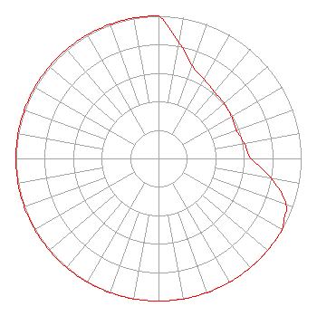 | ||||||||||||||||||
| Azimuth | Ratio | Azimuth | Ratio | Azimuth | Ratio | Azimuth | Ratio | ||||||||||||
| 0 | 1.000 | 5 | 0.910 | 10 | 0.820 | 20 | 0.690 | ||||||||||||
| 30 | 0.640 | 40 | 0.610 | 50 | 0.600 | 60 | 0.590 | ||||||||||||
| 70 | 0.580 | 80 | 0.610 | 90 | 0.650 | 100 | 0.800 | ||||||||||||
| 110 | 0.950 | 115 | 0.975 | 120 | 1.000 | 130 | 1.000 | ||||||||||||
| 140 | 1.000 | 150 | 1.000 | 160 | 1.000 | 170 | 1.000 | ||||||||||||
| 180 | 1.000 | 190 | 1.000 | 200 | 1.000 | 210 | 1.000 | ||||||||||||
| 220 | 1.000 | 230 | 1.000 | 240 | 1.000 | 250 | 1.000 | ||||||||||||
| 260 | 1.000 | 270 | 1.000 | 280 | 1.000 | 290 | 1.000 | ||||||||||||
| 300 | 1.000 | 310 | 1.000 | 320 | 1.000 | 330 | 1.000 | ||||||||||||
| 340 | 1.000 | 350 | 1.000 | ||||||||||||||||
Structure Registration Number 1013171 Structure Type: GTOWER Registered To: Global Tower, LLC. through American Towers, LLC Structure Address: 5375 Pebble Creek Trail (371253) Loves Park, IL County Name: Winnebago County ASR Issued: 11/20/2017 Date Built: 04/09/1998 Site Elevation: 260.9 m (856 ft.) Structure Height: 151.8 m (498 ft.) Height Overall: 152.4 m (500 ft.) Overall Height AMSL: 413.3 m (1356 ft.) FAA Determination: 11/15/2017 FAA Study #: 2017-AGL-19954-OE FAA Circular #: 70/7460-1L Paint & Light FAA Chapters: 4, 8, 12 PRIOR STUDY 1998-AGL-659-OE 42-19-20.0 N 89-00-41.4 W (NAD 83) 42-19-19.9 N 89-00-41.0 W (Converted to NAD 27) |
5700 West Oaks Blvd Rocklin, CA 95765 Phone: 916-251-1600 Not-for-Profit | Date: 04/21/2011 Application Certifier EDUCATIONAL MEDIA FOUNDATION 5700 West Oaks Blvd. Rocklin, CA 95765 Applicant SAM WALLINGTON 5700 West Oaks Blvd Rocklin, CA 95765 VP OF ENGINEERING KAREN A. ROSS, ESQ. Davis Wright Tremaine Llp | |||||||||||||||||