
FCCInfo.com
A Service of Cavell, Mertz & Associates, Inc.
(855) FCC-INFO
|
|
KSQT from 06/24/2023 KNVM from 06/24/2023 KNVM from 08/01/1988 KNVM from 01/27/1988 KNVM from 12/09/1987 |
|
|
||||||||||||||||
|
|
KSQT Channel: 209B 89.7 MHz Prunedale, California Service: FM - A full-service FM station or application. Facility ID: 53696 Fac. Service: FM Status: License Application Accepted: 08/22/2006 Application Granted: 08/25/2006 File Number: BLED-20060822AJC License Expires: 00/00/0000 Prefix Type: This is a license for a noncommercial educational FM station Application Type: License To Cover FCC Website Links: LMS Facility Details This Application CDBS Application Other KSQT Applications Other KSQT Applications in CDBS Including Superseded Applications Mailing Address Correspondence for KSQT Correspondence related to application BLED-20060822AJC Service Contour - Open Street Map or USGS Map (60 dBu) Service Contour - KML / Google Earth (60 dBu) Public Inspection Files Facility Type: NON-COMMERCIAL EDUC. FM Class: B, A Zone I or I-A station; with 25kW-50kW ERP and a class contour distance 39km-52km Site Location: 36-45-21.9 N 121-30-09.8 W (NAD 83) Site Location: 36-45-22.0 N 121-30-06.0 W (Converted to NAD 27) Effective Radiated Power: 0.45 kW Transmitter Output Power: 0.26 kW Antenna Center HAAT: 715 m (2346 ft.) Antenna Center AMSL: 1013 m (3323 ft.) Antenna Center HAG: 78 m (256 ft.) Site Elevation: 935 m. (3068 ft.) Height Overall*: 108 m (354 ft.) (* As Filed In This Application, may differ from ASR Data, Below.) Directional Antenna Antenna Make/Model: None ERI 1091-1CP-DA, 1 section Antenna ID: 72566 Polarization:
| ||||||||||||||||||
| Antenna Data for Antenna Id: 72566 KSQT FM File: BLED-20060822AJC None - ERI 1091-1CP-DA, 1 section Service: FM | 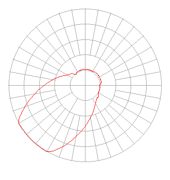 | ||||||||||||||||||
| Azimuth | Ratio | Azimuth | Ratio | Azimuth | Ratio | Azimuth | Ratio | ||||||||||||
| 0 | 0.207 | 10 | 0.207 | 20 | 0.207 | 30 | 0.207 | ||||||||||||
| 40 | 0.216 | 50 | 0.216 | 60 | 0.216 | 70 | 0.216 | ||||||||||||
| 80 | 0.216 | 90 | 0.192 | 100 | 0.194 | 110 | 0.201 | ||||||||||||
| 120 | 0.203 | 130 | 0.229 | 140 | 0.237 | 150 | 0.276 | ||||||||||||
| 160 | 0.341 | 170 | 0.429 | 180 | 0.540 | 190 | 0.680 | ||||||||||||
| 200 | 0.857 | 210 | 1.000 | 220 | 1.000 | 230 | 1.000 | ||||||||||||
| 240 | 1.000 | 250 | 0.838 | 260 | 0.666 | 270 | 0.529 | ||||||||||||
| 280 | 0.420 | 290 | 0.334 | 300 | 0.265 | 310 | 0.230 | ||||||||||||
| 320 | 0.185 | 330 | 0.201 | 340 | 0.202 | 350 | 0.207 | ||||||||||||
Structure Registration Number 1013158 [ASR Heights Differ from KSQT Application] Structure Type: TOWER Registered To: Vertical Bridge S3 Assets, LLC Structure Address: .3 Mi Se Of Fremont Peak Salinas, CA County Name: Monterey County ASR Issued: 04/02/2018 Date Built: 02/01/1981 Site Elevation: 934.5 m (3066 ft.) Structure Height: 106.6 m (350 ft.) Height Overall: 108.2 m (355 ft.) Overall Height AMSL: 1042.7 m (3421 ft.) Paint & Light FAA Chapters: 1, 3, 12, 21 36-45-22.0 N 121-30-10.0 W (NAD 83) 36-45-22.1 N 121-30-06.2 W (Converted to NAD 27) |
399 Encinal Street Santa Cruz, CA 95060 Phone: 831-900-5773 Not-for-Profit | Date: 08/22/2006 Application Certifier PRUNDALE EDUCATIONAL FOUNDATION 8145 Prundale North Road Prundale, CA 93907-8826 Applicant DR. E.L. MOON Prundale Educational Association SAM WALLINGTON 5700 West Oaks Blvd Rocklin, CA 95765 CONSULTING ENGINEER | |||||||||||||||||