
FCCInfo.com
A Service of Cavell, Mertz & Associates, Inc.
(855) FCC-INFO
|
|
|
|
|
|||||||||||||||||||
|
|
KXDD Channel: 281C1 104.1 MHz Yakima, Washington Service: FM - A full-service FM station or application. Facility ID: 7919 Fac. Service: FM Status: License 73.215 Station Application Accepted: 03/05/2002 Application Granted: 03/22/2002 File Number: BLH-20020305AAX License Expires: 00/00/0000 Prefix Type: This is a license for a commercial FM station Application Type: License To Cover FCC Website Links: LMS Facility Details This Application CDBS Application Other KXDD Applications Other KXDD Applications in CDBS Including Superseded Applications Mailing Address Correspondence for KXDD Correspondence related to application BLH-20020305AAX Service Contour - Open Street Map or USGS Map (60 dBu) Service Contour - KML / Google Earth (60 dBu) Public Inspection Files History Cards for KXDD Facility Type: FM STATION Class: C1, A Zone II station; with 50kW-100kW ERP and a class contour distance 52km-72km Site Location: 46-30-47.5 N 120-24-09.2 W (NAD 83) Site Location: 46-30-48.0 N 120-24-05.0 W (Converted to NAD 27) Effective Radiated Power: 100 kW Transmitter Output Power: 29.4 kW Antenna Center HAAT: 245 m (804 ft.) Antenna Center AMSL: 629 m (2064 ft.) Antenna Center HAG: 38 m (125 ft.) Site Elevation: 591 m. (1939 ft.) Height Overall*: 46 m (151 ft.) (* As Filed In This Application, may differ from ASR Data, Below.) Directional Antenna Antenna Make/Model: Shivley 6810-5D-DA Antenna ID: 39691 Polarization: | |||||||||||||||||||||
| Antenna Data for Antenna Id: 39691 KXDD FM File: BLH-20020305AAX Shivley - 6810-5D-DA Service: FM | 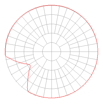 | |||||||||||||||||||||
| Azimuth | Ratio | Azimuth | Ratio | Azimuth | Ratio | Azimuth | Ratio | |||||||||||||||
| 0 | 1.000 | 10 | 1.000 | 20 | 1.000 | 30 | 1.000 | |||||||||||||||
| 40 | 1.000 | 50 | 1.000 | 60 | 1.000 | 70 | 1.000 | |||||||||||||||
| 80 | 1.000 | 90 | 1.000 | 100 | 1.000 | 110 | 1.000 | |||||||||||||||
| 120 | 1.000 | 130 | 1.000 | 140 | 1.000 | 150 | 1.000 | |||||||||||||||
| 160 | 1.000 | 170 | 1.000 | 180 | 1.000 | 190 | 1.000 | |||||||||||||||
| 200 | 1.000 | 210 | 1.000 | 220 | 0.794 | 230 | 0.631 | |||||||||||||||
| 235 | 0.562 | 240 | 0.562 | 250 | 0.708 | 260 | 0.891 | |||||||||||||||
| 265 | 1.000 | 270 | 1.000 | 280 | 1.000 | 290 | 1.000 | |||||||||||||||
| 300 | 1.000 | 310 | 1.000 | 320 | 1.000 | 330 | 1.000 | |||||||||||||||
| 340 | 1.000 | 350 | 1.000 | |||||||||||||||||||
Structure Registration Number 1211770 Structure Type: TOWER Registered To: Butterfield Broadcasting Corp. Structure Address: 2170 Konnowac Pass Rd Yakima, WA County Name: Yakima County ASR Issued: 04/17/2000 Site Elevation: 591.3 m (1940 ft.) Structure Height: 45.7 m (150 ft.) Height Overall: 45.7 m (150 ft.) Overall Height AMSL: 637 m (2090 ft.) FAA Determination: 06/13/1967 FAA Study #: SEA-OE-67-27 FAA Circular #: Paint & Light FAA Chapters: 1, 2 RED LIGHTS/PAINT 46-30-47.4 N 120-24-09.2 W (NAD 83) 46-30-47.9 N 120-24-05.0 W (Converted to NAD 27) |
2448 E. 81st Street Suite 5500 Tulsa, OK 74137 Phone: 918-492-2660 Limited Liability Company | Date: 03/05/2002 Application Certifier NEW NORTHWEST BROADCASTERS LLC 15405 S.e. 37th Street, Suite 130 Bellevue, WA 98006 Applicant ERIK C. SWANSON Hatfield & Dawson Consulting Engineers 9500 Greenwood Ave N Seattle, WA 98103 CONSULTING ENGINEER M. ANNE SWANSON Dow, Lohnes & Albertson, Pllc | ||||||||||||||||||||
|
| |||||||||||||||||||||