|
KIOI-FM2
Call Sign History
KIOI-FM2 from 10/15/1998
980518TC from 10/15/1998
|
101.3 MHz
|
Pleasanton, CA
|
|
KIOI-FM2 Channel: 267D 101.3 MHz
Pleasanton, California
Service: FB - A booster station or application for a booster.
Facility ID: 90740
FRN: 0014042816
Fac. Service: FB Analog & Digital
Programming Delivery Method: Unspecified
Status: LIC
Application Accepted: 02/25/1999
Application Granted: 05/05/1999
File Number: BLFTB-19990225UB
License Expires: 12/01/2029
Prefix Type: This is a license for a booster
Application Type: License To Cover
FCC Website Links:
LMS Facility Details
This Application
Other KIOI-FM2 Applications
Including Superseded Applications
Service Contour - Open Street Map or USGS Map (60 dBu)
Service Contour - KML / Google Earth (60 dBu)
Facility Type: FM STATION
Class: D, A Noncommercial educational operating with no more than 10W
Site Location: 37-39-33.8 N 121-55-57.9 W (NAD 83)
Site Location: 37-39-34.0 N 121-55-54.0 W (Converted to NAD 27)
Effective Radiated Power: 0 kW Horiz. ; 0.9 kW Vert.
Antenna Center HAAT: 0 m
Antenna Center AMSL: 0 m Horiz.; 543 m Vert.
Antenna Center HAG: 0 m Horiz.; 92 m Vert.
Calculated Site Elevation: m.
Height Overall*: 98 m (322 ft.)
(* As Filed In This Application, may differ from ASR Data, Below.)
Directional Antenna
Antenna Make/Model: None
Antenna ID: 15582
Polarization:
| Primary Station |
| KIOI(FM) |
Ch. 267 | San Francisco, California |
|
Antenna Data for Antenna Id: 15582
KIOI-FM2 FB File: BLFTB-19990225UB
None -
Service: FB
|
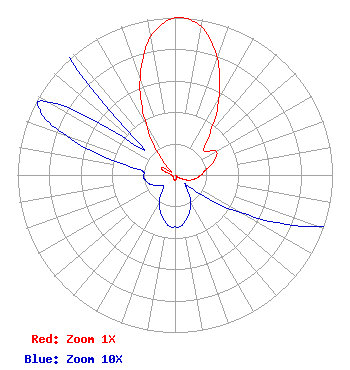 |
| Azimuth | Ratio | Azimuth | Ratio | Azimuth | Ratio | Azimuth | Ratio |
| 0 | 0.998 | 10 | 0.956 | 20 | 0.785 | 30 | 0.557 |
| 40 | 0.346 | 50 | 0.239 | 60 | 0.301 | 70 | 0.267 |
| 80 | 0.201 | 90 | 0.165 | 100 | 0.132 | 110 | 0.096 |
| 120 | 0.048 | 130 | 0.012 | 135 | 0.010 | 140 | 0.012 |
| 150 | 0.020 | 160 | 0.026 | 170 | 0.031 | 175 | 0.033 |
| 180 | 0.033 | 185 | 0.033 | 190 | 0.031 | 200 | 0.026 |
| 210 | 0.020 | 220 | 0.012 | 225 | 0.010 | 230 | 0.010 |
| 240 | 0.013 | 250 | 0.017 | 260 | 0.019 | 265 | 0.020 |
| 270 | 0.020 | 275 | 0.020 | 280 | 0.028 | 290 | 0.073 |
| 295 | 0.094 | 300 | 0.092 | 310 | 0.026 | 320 | 0.138 |
| 330 | 0.367 | 340 | 0.647 | 350 | 0.890 |
Structure Information
Structure Registration Number 1015996
[ASR Heights Differ from KIOI-FM2 Application]
Structure Type: TOWER
Registered To:
American Towers LLC
Structure Address:
9570 Santos Ranch Road (pleasanton #1014)
Pleasanton, CA
County Name: Alameda County
ASR Issued: 01/15/2013
Date Built: 10/01/1997
Site Elevation: 453.5 m (1488 ft.)
Structure Height: 96.6 m (317 ft.)
Height Overall: 96.6 m (317 ft.)
Overall Height AMSL: 550.1 m (1805 ft.)
FAA Determination: 08/23/2011
FAA Study #: 2011-AWP-4805-OE
FAA Circular #: 70/7460-1K
Paint & Light FAA Chapters: 4, 8, 12
PRIOR STUDY 2008-AWP-3030-OE
37-39-34.0 N 121-55-59.5 W (NAD 83)
37-39-34.2 N 121-55-55.6 W
(Converted to NAD 27)
|
KIOI-FM2 Licensee Information
IHM Licenses, LLC
7136 S. Yale Avenue
Suite 501
Tulsa, OK 74136
Phone: 918-664-4581
| 19990225UB Applicant Information
Date: 02/25/1999
Application Certifier
Chancellor Media Corporation of CA.
Chancellor Media Corporation of California
600 Congress Avenue
Suite 1400
Austin, TX 78701
Applicant
|
Associated Land Mobile Licenses
|
| (No Records Found) |
| Associated Microwave Licenses
|
| (No Records Found) |
|
