
FCCInfo.com
A Service of Cavell, Mertz & Associates, Inc.
(855) FCC-INFO
|
|
W254CJ from 10/28/2013 |
|
|
||||||||||||||||
|
|
W254CJ Channel: 254D 98.7 MHz Athens, Georgia Service: FX - A translator or application for a translator. Facility ID: 140316 Fac. Service: FX Programming Delivery Method: Unspecified Status: License Application Accepted: 07/01/2014 Application Granted: 08/05/2014 File Number: BLFT-20140701AAS License Expires: 00/00/0000 Prefix Type: This is a license for a translator Application Type: Amendment FCC Website Links: LMS Facility Details This Application CDBS Application Other W254CJ Applications Other W254CJ Applications in CDBS Including Superseded Applications Mailing Address Correspondence for W254CJ Correspondence related to application BLFT-20140701AAS Service Contour - Open Street Map or USGS Map (60 dBu) Service Contour - KML / Google Earth (60 dBu) Class: D, A Noncommercial educational operating with no more than 10W Site Location: 33-56-28.4 N 83-23-54.6 W (NAD 83) Site Location: 33-56-28.0 N 83-23-55.0 W (Converted to NAD 27) Effective Radiated Power: 0.25 kW Transmitter Output Power: 0.46 kW Antenna Center HAAT: 77 m (253 ft.) Antenna Center AMSL: 297 m (974 ft.) Antenna Center HAG: 93 m (305 ft.) Site Elevation: 204 m. (669 ft.) Height Overall*: 112 m (367 ft.) (* As Filed In This Application, may differ from ASR Data, Below.) Directional Antenna Antenna Make/Model: None Antenna ID: 116965 Polarization:
| ||||||||||||||||||
| Antenna Data for Antenna Id: 116965 W254CJ FX File: BLFT-20140701AAS None - Service: FX | 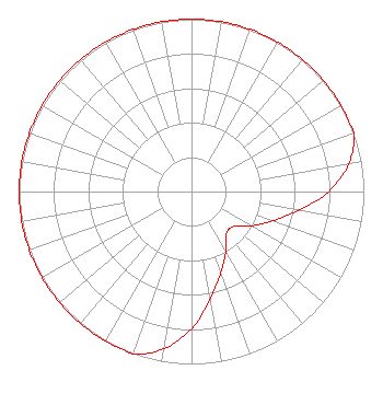 | ||||||||||||||||||
| Azimuth | Ratio | Azimuth | Ratio | Azimuth | Ratio | Azimuth | Ratio | ||||||||||||
| 0 | 1.000 | 10 | 1.000 | 20 | 1.000 | 30 | 1.000 | ||||||||||||
| 40 | 1.000 | 50 | 1.000 | 60 | 1.000 | 70 | 1.000 | ||||||||||||
| 80 | 0.928 | 90 | 0.794 | 100 | 0.631 | 110 | 0.501 | ||||||||||||
| 120 | 0.398 | 130 | 0.316 | 140 | 0.316 | 150 | 0.398 | ||||||||||||
| 160 | 0.501 | 170 | 0.631 | 180 | 0.794 | 190 | 0.927 | ||||||||||||
| 200 | 1.000 | 210 | 1.000 | 220 | 1.000 | 230 | 1.000 | ||||||||||||
| 240 | 1.000 | 250 | 1.000 | 260 | 1.000 | 270 | 1.000 | ||||||||||||
| 280 | 1.000 | 290 | 1.000 | 300 | 1.000 | 310 | 1.000 | ||||||||||||
| 320 | 1.000 | 330 | 1.000 | 340 | 1.000 | 350 | 1.000 | ||||||||||||
Structure Registration Number 1064584 Structure Type: LTOWER Registered To: American Towers LLC Structure Address: 850 Bobbin Mill Road Athens, GA County Name: Clarke County ASR Issued: 08/15/2023 Date Built: 01/01/1950 Site Elevation: 204.2 m (670 ft.) Structure Height: 111.1 m (365 ft.) Height Overall: 112 m (367 ft.) Overall Height AMSL: 316.2 m (1037 ft.) FAA Determination: 01/27/2023 FAA Study #: 2022-ASO-9255-OE FAA Circular #: 70/7460-1M Paint & Light FAA Chapters: 4, 8, 15 PRIOR STUDY 1997-ASO-3528-OE 33-56-28.0 N 83-23-55.0 W (NAD 83) 33-56-27.6 N 83-23-55.4 W (Converted to NAD 27) |
1010 Tower Place Bogart, GA 30622 Phone: 706-549-6222 | Date: 07/01/2014 Application Certifier SOUTHERN BROADCASTING OF PENSACOLA, INC. 112 Middleton Court Athens, GA 30606 Applicant CLYDE SCOTT, JR. Eme Communications 293 Jc Saunders Road Moultrie, GA 31768-0349 CONSULTING ENGINEER PAUL STONE Southern Broadcasting Of Pensacola, Inc. 112 Middleton Court Athens, GA 30606 | |||||||||||||||||