
FCCInfo.com
A Service of Cavell, Mertz & Associates, Inc.
(855) FCC-INFO
|
|
|
|  |
|
|||||||||||||||
|
|
WAWZ Channel: 256B 99.1 MHz Zarephath, New Jersey Service: FM - A full-service FM station or application. Facility ID: 52601 Fac. Service: FM Analog & Digital Status: License Application Accepted: 07/02/2003 Application Granted: 07/21/2003 File Number: BLH-20030702AAO License Expires: 00/00/0000 Prefix Type: This is a license for a commercial FM station Application Type: License To Cover FCC Website Links: LMS Facility Details This Application CDBS Application Other WAWZ Applications Other WAWZ Applications in CDBS Including Superseded Applications Mailing Address Correspondence for WAWZ Correspondence related to application BLH-20030702AAO Service Contour - Open Street Map or USGS Map (54 dBu) Service Contour - KML / Google Earth (54 dBu) Public Inspection Files History Cards for WAWZ Facility Type: FM STATION Class: B, A Zone I or I-A station; with 25kW-50kW ERP and a class contour distance 39km-52km Site Location: 40-36-41.4 N 74-34-10.6 W (NAD 83) Site Location: 40-36-41.0 N 74-34-12.0 W (Converted to NAD 27) Effective Radiated Power: 28 kW Transmitter Output Power: 11.5 kW Antenna Center HAAT: 200 m (656 ft.) Antenna Center AMSL: 265 m (869 ft.) Antenna Center HAG: 85 m (279 ft.) Site Elevation: 180 m. (591 ft.) Height Overall*: 95 m (312 ft.) (* As Filed In This Application, may differ from ASR Data, Below.) Directional Antenna Antenna Make/Model: Electronics Research Inc. MPF-8AC-DA Antenna ID: 39297 Polarization: | ||||||||||||||||||
| Antenna Data for Antenna Id: 39297 WAWZ FM File: BLH-20030702AAO Electronics Research Inc. - MPF-8AC-DA Service: FM | 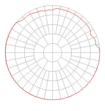 | ||||||||||||||||||
| Azimuth | Ratio | Azimuth | Ratio | Azimuth | Ratio | Azimuth | Ratio | ||||||||||||
| 0 | 0.901 | 5 | 0.933 | 10 | 0.933 | 20 | 0.933 | ||||||||||||
| 30 | 0.933 | 40 | 0.933 | 50 | 0.933 | 55 | 0.933 | ||||||||||||
| 60 | 0.922 | 65 | 0.891 | 70 | 0.922 | 75 | 0.944 | ||||||||||||
| 80 | 0.933 | 85 | 0.988 | 90 | 1.000 | 100 | 1.000 | ||||||||||||
| 110 | 1.000 | 120 | 1.000 | 130 | 1.000 | 140 | 1.000 | ||||||||||||
| 150 | 1.000 | 160 | 1.000 | 170 | 1.000 | 180 | 1.000 | ||||||||||||
| 190 | 1.000 | 200 | 1.000 | 210 | 1.000 | 220 | 1.000 | ||||||||||||
| 230 | 1.000 | 240 | 1.000 | 250 | 1.000 | 260 | 1.000 | ||||||||||||
| 270 | 1.000 | 280 | 1.000 | 290 | 1.000 | 300 | 1.000 | ||||||||||||
| 305 | 0.999 | 310 | 0.988 | 315 | 0.944 | 320 | 0.938 | ||||||||||||
| 325 | 0.938 | 330 | 0.937 | 340 | 0.912 | 345 | 0.912 | ||||||||||||
| 350 | 0.896 | 355 | 0.906 | ||||||||||||||||
Structure Registration Number 1224038 [ASR Heights Differ from WAWZ Application] Structure Type: GTOWER Registered To: Pillar of Fire - WAWZ Structure Address: Mt. Horeb Road Bridgewater Township, NJ County Name: Somerset County ASR Issued: 03/25/2024 Date Built: 06/13/2003 Site Elevation: 179.8 m (590 ft.) Structure Height: 94 m (308 ft.) Height Overall: 97.8 m (321 ft.) Overall Height AMSL: 277.6 m (911 ft.) FAA Determination: 09/18/2023 FAA Study #: 2022-AEA-14595-OE FAA Circular #: 70/7460-1K Paint & Light FAA Chapters: 4, 6, 12 PRIOR STUDY 2007-AEA-692-OE 40-36-40.7 N 74-34-12.7 W (NAD 83) 40-36-40.3 N 74-34-14.1 W (Converted to NAD 27) |
P.o. Box 9058 Zarephath, NJ 08890 Phone: 732-469-0991 Not-for-Profit | Date: 07/02/2003 Application Certifier PILLAR OF FIRE P.o. Box 9058 Zarephath, NJ 08890 Applicant CLARENCE M. BEVERAGE Communications Technologies, Inc. P.o. Box 1130 Marlton, NJ 08053 BROADCAST ENGINEERING CONSULTANT DENNIS F. BEGLEY Reddy Begley & Mccormick, Llp | |||||||||||||||||