
FCCInfo.com
A Service of Cavell, Mertz & Associates, Inc.
(855) FCC-INFO
|
|
WCMS-FM from 02/19/1999 |
|  |
|
|||||||||||||||
|
|
WCMS-FM Channel: 233C1 94.5 MHz Hatteras, North Carolina Service: FM - A full-service FM station or application. Facility ID: 83211 Fac. Service: FM Status: License (Licensed And Silent) 73.215 Station Application Accepted: 08/16/2018 Application Granted: 09/10/2018 File Number: BLH-20180816AAD License Expires: 00/00/0000 Prefix Type: This is a license for a commercial FM station Application Type: License To Cover FCC Website Links: LMS Facility Details This Application CDBS Application Other WCMS-FM Applications Other WCMS-FM Applications in CDBS Including Superseded Applications Mailing Address Correspondence for WCMS-FM Correspondence related to application BLH-20180816AAD Service Contour - Open Street Map or USGS Map (60 dBu) Service Contour - KML / Google Earth (60 dBu) Public Inspection Files Facility Type: FM STATION Class: C1, A Zone II station; with 50kW-100kW ERP and a class contour distance 52km-72km Site Location: 35-29-07.0 N 76-00-01.0 W (NAD 83) Site Location: 35-29-06.4 N 76-00-02.3 W (Converted to NAD 27) Effective Radiated Power: 100 kW Transmitter Output Power: 16 kW Antenna Center HAAT: 299 m (981 ft.) Antenna Center AMSL: 299 m (981 ft.) Antenna Center HAG: 298 m (978 ft.) Site Elevation: 1 m. (3 ft.) Height Overall*: 313 m (1027 ft.) (* As Filed In This Application, may differ from ASR Data, Below.) Directional Antenna Antenna Make/Model: DIELECTRIC DCRM8CD, 8 sections, 1 wavelength spaced Antenna ID: 133288 Polarization: | ||||||||||||||||||
| Antenna Data for Antenna Id: 133288 WCMS-FM FM File: BLH-20180816AAD DIELECTRIC - DCRM8CD, 8 sections, 1 wavelength spaced Service: FM | 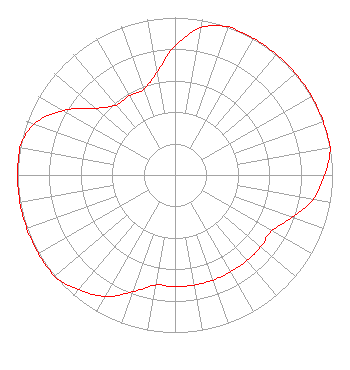 | ||||||||||||||||||
| Azimuth | Ratio | Azimuth | Ratio | Azimuth | Ratio | Azimuth | Ratio | ||||||||||||
| 0 | 0.820 | 10 | 0.950 | 20 | 1.000 | 30 | 1.000 | ||||||||||||
| 40 | 1.000 | 50 | 1.000 | 60 | 1.000 | 70 | 1.000 | ||||||||||||
| 80 | 1.000 | 90 | 0.950 | 100 | 0.890 | 110 | 0.790 | ||||||||||||
| 120 | 0.710 | 130 | 0.710 | 140 | 0.710 | 150 | 0.710 | ||||||||||||
| 160 | 0.710 | 170 | 0.710 | 180 | 0.710 | 190 | 0.710 | ||||||||||||
| 200 | 0.790 | 210 | 0.890 | 220 | 0.950 | 230 | 1.000 | ||||||||||||
| 240 | 1.000 | 250 | 1.000 | 260 | 1.000 | 270 | 1.000 | ||||||||||||
| 280 | 1.000 | 290 | 0.950 | 300 | 0.820 | 310 | 0.660 | ||||||||||||
| 320 | 0.580 | 330 | 0.580 | 340 | 0.580 | 350 | 0.660 | ||||||||||||
Structure Registration Number 1012053 Structure Type: GTOWER Registered To: JAM Media Solutions, LLC Structure Address: 1.8 Mi S Englehard, NC County Name: Hyde County ASR Issued: 10/08/2018 Date Built: 03/31/1999 Site Elevation: 0.6 m (2 ft.) Structure Height: 312.4 m (1025 ft.) Height Overall: 313 m (1027 ft.) Overall Height AMSL: 313.6 m (1029 ft.) FAA Determination: 08/07/2017 FAA Study #: 2017-ASO-9433-OE FAA Circular #: 70/7460-1J Paint & Light FAA Chapters: 4, 5, 7, 9, 13 OM&L to remain the same as prior study = A HIGH-DUAL SYSTEM 35-29-07.0 N 76-00-01.0 W (NAD 83) 35-29-06.4 N 76-00-02.3 W (Converted to NAD 27) |
Mccarter & English, Llp Four Gateway Center, 100 Mulberry Street Newark, NJ 07102 Phone: 973-639-7939 Trustee in Chapter 7 Bankruptcy | Date: 08/16/2018 Application Certifier MAX RADIO OF THE CAROLINAS LICENSES LLC 900 Laskin Road Virginia Beach, VA 23451 Applicant CLARENCE M. BEVERAGE Communications Technologies, Inc. P.o. Box 1130 Marlton, NJ 08053 BROADCAST ENGINEERING CONSULTANT MELODIE A. VIRTUE, ESQ. Garvey Schubert Barer | |||||||||||||||||
| |||||||||||||||||||