
FCCInfo.com
A Service of Cavell, Mertz & Associates, Inc.
(855) FCC-INFO
|
|
KXVV from 09/11/2000 KXVV from 08/01/1997 KXVV from 01/02/1985 |
|
|
||||||||||||||||
|
|
KXVV Channel: 276A 103.1 MHz Victorville, California Service: FM - A full-service FM station or application. Facility ID: 72717 Fac. Service: FM Status: License Application Accepted: 08/08/2005 Application Granted: 09/15/2006 File Number: BLH-20050808ACS License Expires: 00/00/0000 Prefix Type: This is a license for a commercial FM station Application Type: Amendment FCC Website Links: LMS Facility Details This Application CDBS Application Other KXVV Applications Other KXVV Applications in CDBS Including Superseded Applications Mailing Address Correspondence for KXVV Correspondence related to application BLH-20050808ACS Service Contour - Open Street Map or USGS Map (60 dBu) Service Contour - KML / Google Earth (60 dBu) Public Inspection Files History Cards for KXVV Facility Type: FM STATION Class: A, A Zone I; I-A; or II station; with 0.1kW-6kW ERP and a class contour distance <=28km Site Location: 34-36-44.0 N 117-17-32.2 W (NAD 83) Site Location: 34-36-44.0 N 117-17-29.0 W (Converted to NAD 27) Effective Radiated Power: 0.25 kW Transmitter Output Power: 0.217 kW Antenna Center HAAT: 475 m (1558 ft.) Antenna Center AMSL: 1387 m (4551 ft.) Antenna Center HAG: 56 m (184 ft.) Calculated Site Elevation: 1331 m. (4367 ft.) Height Overall*: 59 m (194 ft.) (* As Filed In This Application, may differ from ASR Data, Below.) Directional Antenna Antenna Make/Model: Jampro JMPC-2 RFR DA Antenna ID: 42563 Polarization: | ||||||||||||||||||
| Antenna Data for Antenna Id: 42563 KXVV FM File: BLH-20050808ACS Jampro - JMPC-2 RFR DA Service: FM | 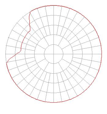 | ||||||||||||||||||
| Azimuth | Ratio | Azimuth | Ratio | Azimuth | Ratio | Azimuth | Ratio | ||||||||||||
| 0 | 1.000 | 10 | 1.000 | 20 | 1.000 | 30 | 1.000 | ||||||||||||
| 40 | 1.000 | 50 | 1.000 | 60 | 1.000 | 70 | 1.000 | ||||||||||||
| 80 | 1.000 | 90 | 1.000 | 100 | 1.000 | 110 | 1.000 | ||||||||||||
| 120 | 1.000 | 130 | 1.000 | 140 | 1.000 | 150 | 1.000 | ||||||||||||
| 160 | 1.000 | 170 | 1.000 | 180 | 1.000 | 190 | 1.000 | ||||||||||||
| 200 | 1.000 | 210 | 1.000 | 220 | 1.000 | 230 | 1.000 | ||||||||||||
| 240 | 1.000 | 250 | 1.000 | 255 | 1.000 | 260 | 0.972 | ||||||||||||
| 270 | 0.772 | 275 | 0.688 | 280 | 0.688 | 290 | 0.688 | ||||||||||||
| 300 | 0.688 | 310 | 0.688 | 315 | 0.688 | 320 | 0.772 | ||||||||||||
| 330 | 0.972 | 335 | 1.000 | 340 | 1.000 | 350 | 1.000 | ||||||||||||
Structure Registration Number 1220067 Structure Type: TOWER Structure Address: 1384quartzite Mountain Oro Grande, CA County Name: San Bernardino County ASR Issued: 04/16/2002 Date Built: 11/27/2000 Site Elevation: 1330.8 m (4366 ft.) Structure Height: 59.4 m (195 ft.) Height Overall: 59.4 m (195 ft.) Overall Height AMSL: 1390.2 m (4561 ft.) FAA Determination: 04/02/2002 FAA Study #: 02-AWP-0597-OE FAA Circular #: 70/7460-1K Paint & Light FAA Chapters: 4, 5, 12 Removed expiration date from determination. Scenario 1./jjs/case#635066 34-36-43.6 N 117-17-32.1 W (NAD 83) 34-36-43.6 N 117-17-28.9 W (Converted to NAD 27) |
11920 Hesperia Road Hesperia, CA 92345 Phone: 760-241-1313 Limited Liability Company | Date: 08/08/2005 Application Certifier INFINITY RADIO INC. Ste 725 2000 K St Nw Washington, DC 20006 Applicant E. LANNY NASS Suite 725 2000 K Street Nw Washington, DC 20006 EMPLOYEE OF PARENT CORPORATION RAYMOND BENEDICT Viacom Inc. | |||||||||||||||||
| |||||||||||||||||||