
FCCInfo.com
A Service of Cavell, Mertz & Associates, Inc.
(855) FCC-INFO
|
|
WKML from 08/03/1981 WKML from 07/31/1978 |
|  |
|
|||||||||||||||
|
|
WKML Channel: 239C0 95.7 MHz Lumberton, North Carolina Service: FM - A full-service FM station or application. Facility ID: 37252 Fac. Service: FM Status: License Application Accepted: 04/25/2012 Application Granted: 05/14/2012 File Number: BMLH-20120425ADL License Expires: 00/00/0000 Prefix Type: This is a modification of a license for a commecial FM station Application Type: Minor Amendment FCC Website Links: LMS Facility Details This Application CDBS Application Other WKML Applications Other WKML Applications in CDBS Including Superseded Applications Mailing Address Correspondence for WKML Correspondence related to application BMLH-20120425ADL Service Contour - Open Street Map or USGS Map (60 dBu) Service Contour - KML / Google Earth (60 dBu) Public Inspection Files History Cards for WKML Facility Type: FM STATION Class: C0, C0 Site Location: 34-46-49.6 N 79-02-44.1 W (NAD 83) Site Location: 34-46-49.0 N 79-02-45.0 W (Converted to NAD 27) Effective Radiated Power: 100 kW Transmitter Output Power: 24.9 kW Antenna Center HAAT: 318 m (1043 ft.) Antenna Center AMSL: 368 m (1207 ft.) Antenna Center HAG: 312 m (1024 ft.) Calculated Site Elevation: 56 m. (184 ft.) Height Overall*: 323 m (1060 ft.) (* As Filed In This Application, may differ from ASR Data, Below.) Directional Antenna Antenna Make/Model: Electronics Research Inc. SHP-8AC6-DA-SP, 8 BAYS, 0.78 WAVELENGTH SPACED Antenna ID: 15135 Polarization: | ||||||||||||||||||
| Antenna Data for Antenna Id: 15135 WKML FM File: BMLH-20120425ADL Electronics Research Inc. - SHP-8AC6-DA-SP, 8 BAYS, 0.78 WAVELENGTH SPACED Service: FM | 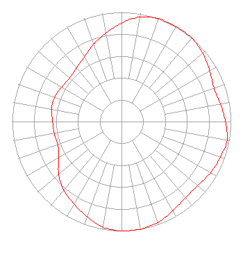 | ||||||||||||||||||
| Azimuth | Ratio | Azimuth | Ratio | Azimuth | Ratio | Azimuth | Ratio | ||||||||||||
| 0 | 0.900 | 10 | 0.970 | 20 | 1.000 | 30 | 1.000 | ||||||||||||
| 40 | 1.000 | 50 | 0.970 | 60 | 0.930 | 70 | 0.900 | ||||||||||||
| 80 | 0.920 | 90 | 0.950 | 100 | 0.980 | 110 | 0.960 | ||||||||||||
| 120 | 0.940 | 130 | 0.910 | 140 | 0.910 | 150 | 0.940 | ||||||||||||
| 160 | 0.980 | 170 | 1.000 | 180 | 1.000 | 190 | 0.980 | ||||||||||||
| 200 | 0.925 | 210 | 0.870 | 220 | 0.820 | 230 | 0.750 | ||||||||||||
| 240 | 0.660 | 250 | 0.620 | 260 | 0.625 | 270 | 0.630 | ||||||||||||
| 280 | 0.650 | 290 | 0.650 | 300 | 0.630 | 310 | 0.620 | ||||||||||||
| 320 | 0.640 | 330 | 0.680 | 340 | 0.750 | 350 | 0.820 | ||||||||||||
Structure Registration Number 1006418 [ASR Heights Differ from WKML Application] Structure Type: TOWER Registered To: GTC Uno, LLC Structure Address: Mary C Rd Rennert, NC County Name: Robeson County ASR Issued: 12/27/2023 Date Built: 01/01/1985 Site Elevation: 56.7 m (186 ft.) Structure Height: 323.4 m (1061 ft.) Height Overall: 323.4 m (1061 ft.) Overall Height AMSL: 380.1 m (1247 ft.) FAA Determination: 11/08/1996 FAA Study #: 96-ASO-5180-OE FAA Circular #: 70/7460-1G Paint & Light FAA Chapters: 4, 7, 9 HIGH INTENSITY WHITE LIGHTS 34-46-50.0 N 79-02-44.0 W (NAD 83) 34-46-49.4 N 79-02-44.9 W (Converted to NAD 27) |
3033 Riviera Drive Suite 200 Naples, FL 34103 Phone: 239-263-5000 Limited Liability Company | Date: 04/25/2012 Application Certifier WKML LICENSE LIMITED PARTNERSHIP 3033 Riviera Drive, Suite 200 Naples, FL 34103 Applicant DENNIS P. CORBETT, ESQ. Lerman Senter Pllc JEFFERSON G. BROCK Graham Brock, Inc. P. O. Box 24466 St. Simons Island, GA 31522-7466 TECHNICAL CONSULTANT | |||||||||||||||||
|
| ||||||||||||||||||