
FCCInfo.com
A Service of Cavell, Mertz & Associates, Inc.
(855) FCC-INFO
|
|
|
|
|
||||||||||||||||
|
|
KMLV Channel: 201C0 88.1 MHz Ralston, Nebraska Service: FM - A full-service FM station or application. Facility ID: 85846 Fac. Service: FM Status: License Application Accepted: 07/29/2010 Application Granted: 08/09/2010 File Number: BMLED-20100729AEG License Expires: 00/00/0000 Prefix Type: This is a modification of license for a noncommercial educational FM station Application Type: Minor Modification FCC Website Links: LMS Facility Details This Application CDBS Application Other KMLV Applications Other KMLV Applications in CDBS Including Superseded Applications Mailing Address Correspondence for KMLV Correspondence related to application BMLED-20100729AEG Service Contour - Open Street Map or USGS Map (60 dBu) Service Contour - KML / Google Earth (60 dBu) Public Inspection Files Facility Type: NON-COMMERCIAL EDUC. FM Class: C0, C0 Site Location: 41-18-40.0 N 96-01-38.1 W (NAD 83) Site Location: 41-18-40.0 N 96-01-37.0 W (Converted to NAD 27) Effective Radiated Power: 59 kW Transmitter Output Power: 21.94 kW Antenna Center HAAT: 390 m (1280 ft.) Antenna Center AMSL: 731 m (2398 ft.) Antenna Center HAG: 367 m (1204 ft.) Calculated Site Elevation: 364 m. (1194 ft.) Height Overall*: 409 m (1342 ft.) (* As Filed In This Application, may differ from ASR Data, Below.) Directional Antenna Antenna Make/Model: Electronics Research Inc. MP-8C-DA-HW Antenna ID: 100308 Polarization: | ||||||||||||||||||
| Antenna Data for Antenna Id: 100308 KMLV FM File: BMLED-20100729AEG Electronics Research Inc. - MP-8C-DA-HW Service: FM | 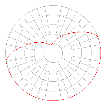 | ||||||||||||||||||
| Azimuth | Ratio | Azimuth | Ratio | Azimuth | Ratio | Azimuth | Ratio | ||||||||||||
| 0 | 0.214 | 10 | 0.269 | 20 | 0.339 | 30 | 0.427 | ||||||||||||
| 40 | 0.538 | 50 | 0.677 | 60 | 0.852 | 70 | 1.000 | ||||||||||||
| 80 | 1.000 | 90 | 1.000 | 100 | 1.000 | 110 | 1.000 | ||||||||||||
| 120 | 1.000 | 130 | 1.000 | 140 | 1.000 | 150 | 1.000 | ||||||||||||
| 160 | 1.000 | 170 | 1.000 | 180 | 1.000 | 190 | 1.000 | ||||||||||||
| 200 | 1.000 | 210 | 1.000 | 220 | 1.000 | 230 | 1.000 | ||||||||||||
| 240 | 1.000 | 250 | 1.000 | 260 | 1.000 | 270 | 0.872 | ||||||||||||
| 280 | 0.693 | 290 | 0.550 | 300 | 0.437 | 310 | 0.347 | ||||||||||||
| 320 | 0.276 | 330 | 0.219 | 340 | 0.178 | 350 | 0.178 | ||||||||||||
Structure Registration Number 1026518 [ASR Heights Differ from KMLV Application] Structure Type: 2TOWER Registered To: Gray Media Group, Inc. Structure Address: 5800 North 72nd Street Omaha, NE County Name: Douglas County ASR Issued: 09/09/2020 Site Elevation: 363.5 m (1193 ft.) Structure Height: 387 m (1270 ft.) Height Overall: 409 m (1342 ft.) Overall Height AMSL: 772.5 m (2534 ft.) Paint & Light FAA Chapters: 1, 3, 9, 18, 21 41-18-40.0 N 96-01-38.0 W (NAD 83) 41-18-40.0 N 96-01-36.9 W (Converted to NAD 27) |
5700 West Oaks Boulevard Rocklin, CA 95765 Phone: 916-251-1600 Not-for-Profit | Date: 07/29/2010 Application Certifier EDUCATIONAL MEDIA FOUNDATION 5700 West Oaks Blvd Rocklin, CA 95765 Applicant SAM WALLINGTON 5700 West Oaks Blvd Rocklin, CA 95765 VP OF ENGINEERING KAREN A. ROSS, ESQ Davis Wright Tremaine Llp | |||||||||||||||||