
FCCInfo.com
A Service of Cavell, Mertz & Associates, Inc.
(855) FCC-INFO
|
|
WGBG-FM from 02/06/1996 WGBG-FM from 12/26/1983 WGBG-FM from 07/24/1981 |
|  |
|
|||||||||||||||
|
|
WGBG-FM Channel: 299B1 107.7 MHz Fruitland, Maryland Service: FM - A full-service FM station or application. Facility ID: 4107 Fac. Service: FM Status: License 73.215 Station Application Accepted: 04/25/2016 Application Granted: 05/06/2016 File Number: BLH-20160425AAO License Expires: 00/00/0000 Prefix Type: This is a license for a commercial FM station Application Type: License To Cover FCC Website Links: LMS Facility Details This Application CDBS Application Other WGBG-FM Applications Other WGBG-FM Applications in CDBS Including Superseded Applications Mailing Address Correspondence for WGBG-FM Correspondence related to application BLH-20160425AAO Service Contour - Open Street Map or USGS Map (57 dBu) Service Contour - KML / Google Earth (57 dBu) Public Inspection Files History Cards for WGBG-FM Facility Type: FM STATION Class: B1, A Zone I or I-A station; with 6kW-25kW ERP and a class contour distance 28km-39km Site Location: 38-23-00.4 N 75-24-51.7 W (NAD 83) Site Location: 38-22-60.0 N 75-24-53.0 W (Converted to NAD 27) Effective Radiated Power: 23 kW Transmitter Output Power: 17.15 kW Antenna Center HAAT: 104.8 m (344 ft.) Antenna Center AMSL: 118.3 m (388 ft.) Antenna Center HAG: 102.5 m (336 ft.) Calculated Site Elevation: 15.8 m. (52 ft.) Height Overall*: 108.2 m (355 ft.) (* As Filed In This Application, may differ from ASR Data, Below.) Directional Antenna Antenna Make/Model: Systems With Reliability Inc. FM10D/2-CF-0.75WS-DA, 2 bays, 0.75 wavelength Antenna ID: 122522 Polarization: | ||||||||||||||||||
| Antenna Data for Antenna Id: 122522 WGBG-FM FM File: BLH-20160425AAO Systems With Reliability Inc. - FM10D/2-CF-0.75WS-DA, 2 bays, 0.75 wavelength Service: FM | 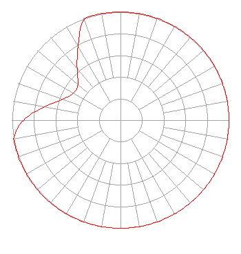 | ||||||||||||||||||
| Azimuth | Ratio | Azimuth | Ratio | Azimuth | Ratio | Azimuth | Ratio | ||||||||||||
| 0 | 1.000 | 10 | 1.000 | 20 | 1.000 | 30 | 1.000 | ||||||||||||
| 40 | 1.000 | 50 | 1.000 | 60 | 1.000 | 70 | 1.000 | ||||||||||||
| 80 | 1.000 | 90 | 1.000 | 100 | 1.000 | 110 | 1.000 | ||||||||||||
| 120 | 1.000 | 130 | 1.000 | 140 | 1.000 | 150 | 1.000 | ||||||||||||
| 160 | 1.000 | 170 | 1.000 | 180 | 1.000 | 190 | 1.000 | ||||||||||||
| 200 | 1.000 | 210 | 1.000 | 220 | 1.000 | 230 | 1.000 | ||||||||||||
| 240 | 1.000 | 250 | 1.000 | 260 | 1.000 | 270 | 0.894 | ||||||||||||
| 280 | 0.710 | 290 | 0.564 | 300 | 0.500 | 310 | 0.513 | ||||||||||||
| 320 | 0.622 | 330 | 0.783 | 340 | 0.986 | 350 | 1.000 | ||||||||||||
Structure Registration Number 1036465 Structure Type: GTOWER Registered To: Pinnacle Towers LLC Structure Address: 34684 Warren Road Pittsville, MD County Name: Wicomico County ASR Issued: 05/06/2016 Date Built: 09/01/1997 Site Elevation: 15.8 m (52 ft.) Structure Height: 100.6 m (330 ft.) Height Overall: 108.2 m (355 ft.) Overall Height AMSL: 124 m (407 ft.) FAA Determination: 07/27/2012 FAA Study #: 2012-AEA-3491-OE FAA Circular #: 70/7460-1J Paint & Light FAA Chapters: 3, 4, 5, 13 OM&L to remain the same as prior study = PAINT/RED LIGHTS 38-23-00.3 N 75-24-51.9 W (NAD 83) 38-22-59.9 N 75-24-53.2 W (Converted to NAD 27) |
1729 North Salisbury Blvd. Salisbury, MD 21801 Phone: 443-880-9090 Corporation | Date: 04/25/2016 Application Certifier ADAMS RADIO OF DELMARVA PENINSULA, LLC 16233 Kenyon Ave. Suite 110 Lakeville, MN 55069 Applicant JUSTIN W. ASHER Munn-reese, Inc. Po Box 220, 385 Airport Drive Coldwater, MI 49036-0220 CONSULTING ENGINEER GREGG P. SKALL, ESQ. Womble Carlyle Sandridge & Rice, Pllc | |||||||||||||||||
| |||||||||||||||||||