
FCCInfo.com
A Service of Cavell, Mertz & Associates, Inc.
(855) FCC-INFO
|
|
WHVK from 11/07/2007 |
|
|
||||||||||||||||
|
|
WHVK Channel: 278C3 103.5 MHz New Hope, Alabama Service: FM - A full-service FM station or application. Facility ID: 170944 Fac. Service: FM Analog & Digital Status: License 73.215 Station Application Accepted: 11/14/2016 Application Granted: 12/29/2016 File Number: BLED-20161114ACO License Expires: 00/00/0000 Prefix Type: This is a license for a noncommercial educational FM station Application Type: License To Cover FCC Website Links: LMS Facility Details This Application CDBS Application Other WHVK Applications Other WHVK Applications in CDBS Including Superseded Applications Mailing Address Correspondence for WHVK Correspondence related to application BLED-20161114ACO Service Contour - Open Street Map or USGS Map (60 dBu) Service Contour - KML / Google Earth (60 dBu) Public Inspection Files Facility Type: NON-COMMERCIAL EDUC. FM Class: C3, A Zone II station; with 6kW-25kW ERP and a class contour distance 28km-39km Site Location: 34-38-11.3 N 86-30-42.0 W (NAD 83) Site Location: 34-38-11.0 N 86-30-42.0 W (Converted to NAD 27) Effective Radiated Power: 0.9 kW Transmitter Output Power: 2.233 kW Antenna Center HAAT: 463 m (1519 ft.) Antenna Center AMSL: 690 m (2264 ft.) Antenna Center HAG: 245 m (804 ft.) Calculated Site Elevation: 445 m. (1460 ft.) Height Overall*: 290 m (951 ft.) (* As Filed In This Application, may differ from ASR Data, Below.) Directional Antenna Antenna Make/Model: Shivley 6810-1R-DA Antenna ID: 125678 Polarization:
| ||||||||||||||||||
| Antenna Data for Antenna Id: 125678 WHVK FM File: BLED-20161114ACO Shivley - 6810-1R-DA Service: FM | 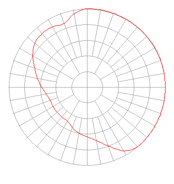 | ||||||||||||||||||
| Azimuth | Ratio | Azimuth | Ratio | Azimuth | Ratio | Azimuth | Ratio | ||||||||||||
| 0 | 1.000 | 10 | 1.000 | 20 | 1.000 | 30 | 1.000 | ||||||||||||
| 40 | 1.000 | 50 | 1.000 | 60 | 1.000 | 70 | 1.000 | ||||||||||||
| 80 | 1.000 | 90 | 1.000 | 100 | 1.000 | 110 | 1.000 | ||||||||||||
| 120 | 1.000 | 130 | 1.000 | 140 | 1.000 | 150 | 0.940 | ||||||||||||
| 160 | 0.801 | 170 | 0.693 | 180 | 0.634 | 190 | 0.598 | ||||||||||||
| 200 | 0.550 | 210 | 0.500 | 220 | 0.500 | 230 | 0.500 | ||||||||||||
| 240 | 0.500 | 250 | 0.500 | 260 | 0.529 | 270 | 0.580 | ||||||||||||
| 280 | 0.645 | 290 | 0.712 | 300 | 0.800 | 310 | 0.870 | ||||||||||||
| 320 | 0.890 | 330 | 0.885 | 340 | 0.861 | 350 | 0.948 | ||||||||||||
Structure Registration Number 1035654 Structure Type: TOWER Registered To: Pinnacle Towers LLC Structure Address: Green Mountain Huntsville, AL County Name: Madison County ASR Issued: 05/06/2016 Date Built: 03/01/1985 Site Elevation: 445 m (1460 ft.) Structure Height: 290.2 m (952 ft.) Height Overall: 290.2 m (952 ft.) Overall Height AMSL: 735.2 m (2412 ft.) FAA Determination: 03/16/2010 FAA Study #: 2010-ASO-406-OE Paint & Light FAA Chapters: 1, 3, 7, 16, 21 PRIOR STUDY 2008-ASO-2709-OE 34-38-11.0 N 86-30-42.0 W (NAD 83) 34-38-10.7 N 86-30-42.0 W (Converted to NAD 27) Crown Castle 1035654 - Pinnacle Towers LLC |
5700 West Oaks Blvd. Rocklin, CA 95765 Phone: 916-251-1766 Not-for-Profit | Date: 11/14/2016 Application Certifier EDUCATIONAL MEDIA FOUNDATION 5700 West Oaks Blvd Rocklin, CA 95765 Applicant MARY O'CONNOR Wilkinson Barker Knauer, Llp STEPHEN WILDE 5700 West Oaks Blvd Rocklin, CA 95765 RF DESIGN ENGINEER | |||||||||||||||||