
FCCInfo.com
A Service of Cavell, Mertz & Associates, Inc.
(855) FCC-INFO
|
|
W211BZ from 07/08/1996 |
|
|
||||||||||||||||
|
|
W211BZ Channel: 211D 90.1 MHz Galena, Illinois Service: FX - A translator or application for a translator. Facility ID: 78602 Fac. Service: FX Programming Delivery Method: Unspecified Status: License Application Accepted: 10/05/2007 Application Granted: 10/17/2007 File Number: BLFT-20071005AAE License Expires: 00/00/0000 Prefix Type: This is a license for a translator Application Type: License To Cover FCC Website Links: LMS Facility Details This Application CDBS Application Other W211BZ Applications Other W211BZ Applications in CDBS Including Superseded Applications Mailing Address Correspondence for W211BZ Correspondence related to application BLFT-20071005AAE Service Contour - Open Street Map or USGS Map (60 dBu) Service Contour - KML / Google Earth (60 dBu) Class: D, A Noncommercial educational operating with no more than 10W Site Location: 42-24-02.0 N 90-23-55.5 W (NAD 83) Site Location: 42-24-02.0 N 90-23-55.0 W (Converted to NAD 27) Effective Radiated Power: 0 kW Horiz. ; 0.016 kW Vert. Transmitter Output Power: 0.05 kW Antenna Center HAAT: 0 m Horiz.; 98.4 m Vert. Antenna Center AMSL: 0 m Horiz.; 341 m Vert. Antenna Center HAG: 0 m Horiz.; 67 m Vert. Site Elevation: 274 m. (899 ft.) Height Overall*: 76 m (249 ft.) (* As Filed In This Application, may differ from ASR Data, Below.) Directional Antenna Antenna Make/Model: None Antenna ID: 80133 Polarization:
| ||||||||||||||||||
| Antenna Data for Antenna Id: 80133 W211BZ FX File: BLFT-20071005AAE None - Service: FX Pattern and Field Values Include a 285° Clockwise Rotation | 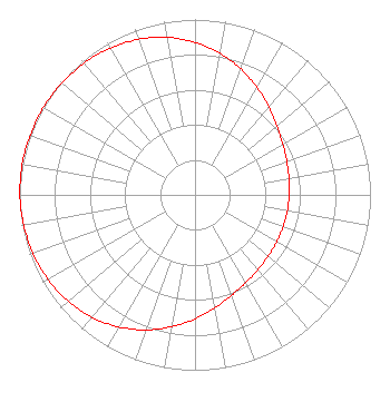 | ||||||||||||||||||
| Azimuth | Ratio | Azimuth | Ratio | Azimuth | Ratio | Azimuth | Ratio | ||||||||||||
| 5 | 0.845 | 15 | 0.792 | 25 | 0.735 | 35 | 0.679 | ||||||||||||
| 45 | 0.630 | 55 | 0.592 | 65 | 0.566 | 75 | 0.549 | ||||||||||||
| 85 | 0.540 | 95 | 0.535 | 105 | 0.534 | 115 | 0.535 | ||||||||||||
| 125 | 0.540 | 135 | 0.549 | 145 | 0.566 | 155 | 0.592 | ||||||||||||
| 165 | 0.630 | 175 | 0.679 | 185 | 0.735 | 195 | 0.792 | ||||||||||||
| 205 | 0.845 | 215 | 0.892 | 225 | 0.929 | 235 | 0.956 | ||||||||||||
| 245 | 0.975 | 255 | 0.987 | 265 | 0.995 | 275 | 0.999 | ||||||||||||
| 285 | 1.000 | 295 | 0.999 | 305 | 0.995 | 315 | 0.987 | ||||||||||||
| 325 | 0.975 | 335 | 0.956 | 345 | 0.929 | 355 | 0.892 | ||||||||||||
Structure Registration Number 1009837 [ASR Heights Differ from W211BZ Application] Structure Type: TOWER Registered To: VB-S1 Assets, LLC Structure Address: South Of Us 20; 3.14 Miles East Of Galena Galena, IL County Name: Jo Daviess County ASR Issued: 01/30/2018 Date Built: 01/01/1987 Site Elevation: 320 m (1050 ft.) Structure Height: 78.3 m (257 ft.) Height Overall: 79.2 m (260 ft.) Overall Height AMSL: 399.2 m (1310 ft.) FAA Determination: 03/27/2008 FAA Study #: 2008-AGL-1892-OE FAA Circular #: 70/7460-1G Paint & Light FAA Chapters: 3, 4, 5, 9 42-24-00.9 N 90-23-39.3 W (NAD 83) 42-24-00.9 N 90-23-38.8 W (Converted to NAD 27) |
820 N Lasalle St Chicago, IL 60610-3214 Phone: 312-329-4438 | Date: 10/05/2007 Application Certifier THE MOODY BIBLE INSTITUTE OF CHICAGO 820 North Lasalle Boulevard Chicago, IL 60610-3284 Applicant JEFFREY D SOUTHMAYD Southmayd & Miller 1220 19th Street Nw 3400 Washington, DC 20036 ATTORNEY JEFFREY D. SOUTHMAYD Southmayd & Miller 1220 19th Street, N.w. Suite 400 Washington, DC 20036 | |||||||||||||||||