
FCCInfo.com
A Service of Cavell, Mertz & Associates, Inc.
(855) FCC-INFO
|
|
W263BZ from 10/01/2004 |
|
|
||||||||||||||||
|
|
W263BZ Channel: 263D 100.5 MHz Portland, Maine Service: FX - A translator or application for a translator. Facility ID: 150133 Fac. Service: FX Programming Delivery Method: Unspecified Status: License Application Accepted: 03/14/2016 Application Granted: 03/21/2016 File Number: BLFT-20160314AAI License Expires: 00/00/0000 Prefix Type: This is a license for a translator Application Type: License To Cover FCC Website Links: LMS Facility Details This Application CDBS Application Other W263BZ Applications Other W263BZ Applications in CDBS Including Superseded Applications Mailing Address Correspondence for W263BZ Correspondence related to application BLFT-20160314AAI Service Contour - Open Street Map or USGS Map (60 dBu) Service Contour - KML / Google Earth (60 dBu) Class: D, A Noncommercial educational operating with no more than 10W Site Location: 43-44-38.3 N 70-19-59.2 W (NAD 83) Site Location: 43-44-38.0 N 70-20-01.0 W (Converted to NAD 27) Effective Radiated Power: 0.25 kW Transmitter Output Power: 0.275 kW Antenna Center HAAT: 0 m Antenna Center AMSL: 263 m (863 ft.) Antenna Center HAG: 137 m (449 ft.) Site Elevation: 126 m. (413 ft.) Height Overall*: 140 m (459 ft.) (* As Filed In This Application, may differ from ASR Data, Below.) Directional Antenna Antenna Make/Model: None Antenna ID: 122104 Polarization:
| ||||||||||||||||||
| Antenna Data for Antenna Id: 122104 W263BZ FX File: BLFT-20160314AAI None - Service: FX | 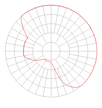 | ||||||||||||||||||
| Azimuth | Ratio | Azimuth | Ratio | Azimuth | Ratio | Azimuth | Ratio | ||||||||||||
| 0 | 1.000 | 10 | 1.000 | 20 | 1.000 | 30 | 1.000 | ||||||||||||
| 40 | 1.000 | 50 | 1.000 | 60 | 1.000 | 70 | 1.000 | ||||||||||||
| 80 | 1.000 | 90 | 1.000 | 100 | 1.000 | 110 | 1.000 | ||||||||||||
| 120 | 1.000 | 130 | 1.000 | 140 | 1.000 | 150 | 0.900 | ||||||||||||
| 160 | 0.700 | 170 | 0.360 | 180 | 0.260 | 190 | 0.230 | ||||||||||||
| 200 | 0.230 | 210 | 0.230 | 220 | 0.230 | 230 | 0.300 | ||||||||||||
| 240 | 0.400 | 250 | 0.500 | 260 | 0.600 | 270 | 0.600 | ||||||||||||
| 280 | 0.600 | 290 | 0.600 | 300 | 0.600 | 310 | 0.800 | ||||||||||||
| 320 | 1.000 | 330 | 1.000 | 340 | 1.000 | 350 | 1.000 | ||||||||||||
Structure Registration Number 1018653 Structure Type: TOWER Registered To: TOWER SPECIALISTS INC Structure Address: 115 Hardy Rd Falmouth, ME County Name: Cumberland County ASR Issued: 09/11/2009 Date Built: 09/11/2009 Site Elevation: 126.4 m (415 ft.) Structure Height: 128 m (420 ft.) Height Overall: 139.9 m (459 ft.) Overall Height AMSL: 266.3 m (874 ft.) FAA Determination: 09/03/2009 FAA Study #: 2009-ANE-752-OE FAA Circular #: 70/7460-1K Paint & Light FAA Chapters: 3, 4, 5, 12 PRIOR STUDY 2006-ANE-486-OE 43-44-38.3 N 70-19-59.0 W (NAD 83) 43-44-38.0 N 70-20-00.8 W (Converted to NAD 27) |
779 Warren Avenue Portland, ME 04103 Phone: 207-773-9695 | Date: 03/14/2016 Application Certifier ATLANTIC COAST RADIO, LLC 779 Warren Avenue Portland, ME 04103 Applicant ROBERT D PERRY, JR 96 Cook St Auburn, ME 04210-5618 CONSULTING CONTRACT ENGINEER MELODIE A. VIRTUE, ESQ. Garvey Schubert Barer 1000 Potomac Street, N.w. Suite 200 Washington, DC 20007-3501 | |||||||||||||||||