
FCCInfo.com
A Service of Cavell, Mertz & Associates, Inc.
(855) FCC-INFO
|
|
|
|
|
||||||||||||||||
|
|
W230AA Channel: 230D 93.9 MHz Atlantic City, New Jersey Service: FX - A translator or application for a translator. Facility ID: 41178 Fac. Service: FX Programming Delivery Method: Unspecified Status: License Application Accepted: 06/12/2017 Application Granted: 06/23/2017 File Number: BLFT-20170612ABX License Expires: 06/01/2030 Prefix Type: This is a license for a translator Application Type: License To Cover FCC Website Links: LMS Facility Details This Application CDBS Application Other W230AA Applications Other W230AA Applications in CDBS Including Superseded Applications Mailing Address Correspondence for W230AA Correspondence related to application BLFT-20170612ABX Service Contour - Open Street Map or USGS Map (60 dBu) Service Contour - KML / Google Earth (60 dBu) Class: D, A Noncommercial educational operating with no more than 10W Site Location: 39-22-35.4 N 74-33-42.6 W (NAD 83) Site Location: 39-22-35.0 N 74-33-44.0 W (Converted to NAD 27) Effective Radiated Power: 0.25 kW Transmitter Output Power: 0.177 kW Antenna Center HAAT: 0 m Antenna Center AMSL: 101 m (331 ft.) Antenna Center HAG: 95 m (312 ft.) Site Elevation: 6 m. (20 ft.) Height Overall*: 108 m (354 ft.) (* As Filed In This Application, may differ from ASR Data, Below.) Directional Antenna Antenna Make/Model: BXT TFC2K-4-0.85 Wavelength Antenna ID: 127166 Polarization: H
| ||||||||||||||||||
| Antenna Data for Antenna Id: 127166 W230AA FX File: BLFT-20170612ABX BXT - TFC2K-4-0.85 Wavelength Service: FX | 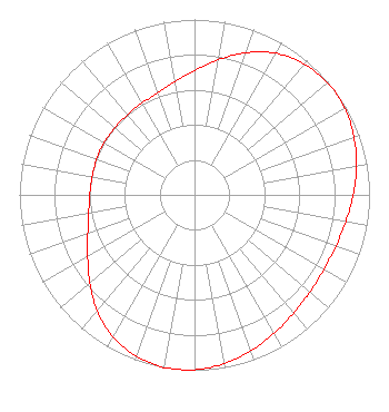 | ||||||||||||||||||
| Azimuth | Ratio | Azimuth | Ratio | Azimuth | Ratio | Azimuth | Ratio | ||||||||||||
| 0 | 0.707 | 10 | 0.782 | 20 | 0.863 | 30 | 0.932 | ||||||||||||
| 40 | 0.974 | 50 | 0.993 | 60 | 0.990 | 70 | 0.969 | ||||||||||||
| 80 | 0.940 | 90 | 0.907 | 100 | 0.878 | 110 | 0.859 | ||||||||||||
| 120 | 0.853 | 130 | 0.861 | 140 | 0.881 | 150 | 0.911 | ||||||||||||
| 160 | 0.945 | 170 | 0.976 | 180 | 0.997 | 190 | 1.000 | ||||||||||||
| 200 | 0.978 | 210 | 0.934 | 220 | 0.864 | 230 | 0.781 | ||||||||||||
| 240 | 0.705 | 250 | 0.649 | 260 | 0.614 | 270 | 0.598 | ||||||||||||
| 280 | 0.594 | 290 | 0.595 | 300 | 0.596 | 310 | 0.596 | ||||||||||||
| 320 | 0.596 | 330 | 0.602 | 340 | 0.619 | 350 | 0.652 | ||||||||||||
Structure Registration Number 1053552 [ASR Heights Differ from W230AA Application] Structure Type: GTOWER Registered To: American Towers LLC Structure Address: Burton Ave. (000062 / Northfield Nj) Northfield, NJ County Name: Atlantic County ASR Issued: 08/31/2016 Date Built: 09/06/2003 Site Elevation: 5.5 m (18 ft.) Structure Height: 106.6 m (350 ft.) Height Overall: 107.5 m (353 ft.) Overall Height AMSL: 113 m (371 ft.) FAA Determination: 05/11/2016 FAA Study #: 2016-AEA-4573-OE FAA Circular #: 70/7460-1L Paint & Light FAA Chapters: 4, 8, 12 PRIOR STUDY 2013-AEA-3440-OE 39-22-35.8 N 74-33-42.2 W (NAD 83) 39-22-35.4 N 74-33-43.6 W (Converted to NAD 27) |
1200 Old Trenton Road West Windsor, NJ 08550 Phone: 609-570-3703 Not-for-Profit | Date: 06/12/2017 Application Certifier MERCER COUNTY COMMUNITY COLLEGE 1200 Old Trenton Road West Windsor, NJ 08550 Applicant THOMAS MCNALLY 950 Tilton Road Suite 200 Northfield, NJ 08225 CONSULTING ENGINEER LEE J. PELTZMAN Shainis & Peltzman, Chartered 1850 M Street, Nw Suite 240 Washington, DC 20036 | |||||||||||||||||