
FCCInfo.com
A Service of Cavell, Mertz & Associates, Inc.
(855) FCC-INFO
|
|
|
|
|
||||||||||||||||
|
|
WQXB Channel: 261C2 100.1 MHz Grenada, Mississippi Service: FM - A full-service FM station or application. Facility ID: 10672 Fac. Service: FM Status: License 73.215 Station Application Accepted: 07/25/2003 Application Granted: 09/15/2003 File Number: BLH-20030725ADA License Expires: 00/00/0000 Prefix Type: This is a license for a commercial FM station Application Type: Amendment FCC Website Links: LMS Facility Details This Application CDBS Application Other WQXB Applications Other WQXB Applications in CDBS Including Superseded Applications Mailing Address Correspondence for WQXB Correspondence related to application BLH-20030725ADA Service Contour - Open Street Map or USGS Map (60 dBu) Service Contour - KML / Google Earth (60 dBu) Public Inspection Files History Cards for WQXB Facility Type: FM STATION Class: C2, A Zone II station; with 25kW-50kW ERP and a class contour distance 39km-52km Site Location: 33-51-24.4 N 89-55-15.3 W (NAD 83) Site Location: 33-51-24.0 N 89-55-15.0 W (Converted to NAD 27) Effective Radiated Power: 48 kW Transmitter Output Power: 10.34 kW Antenna Center HAAT: 153.3 m (503 ft.) Antenna Center AMSL: 237.3 m (779 ft.) Antenna Center HAG: 127 m (417 ft.) Calculated Site Elevation: 110.3 m. (362 ft.) Height Overall*: 137.2 m (450 ft.) (* As Filed In This Application, may differ from ASR Data, Below.) Directional Antenna Antenna Make/Model: Systems With Reliability Inc. FM10/6 DA Antenna ID: 46289 Polarization: | ||||||||||||||||||
| Antenna Data for Antenna Id: 46289 WQXB FM File: BLH-20030725ADA Systems With Reliability Inc. - FM10/6 DA Service: FM | 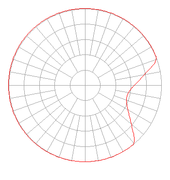 | ||||||||||||||||||
| Azimuth | Ratio | Azimuth | Ratio | Azimuth | Ratio | Azimuth | Ratio | ||||||||||||
| 0 | 1.000 | 10 | 1.000 | 20 | 1.000 | 30 | 1.000 | ||||||||||||
| 40 | 1.000 | 50 | 1.000 | 60 | 1.000 | 70 | 0.990 | ||||||||||||
| 80 | 0.790 | 90 | 0.646 | 100 | 0.577 | 110 | 0.577 | ||||||||||||
| 120 | 0.646 | 130 | 0.790 | 140 | 0.990 | 150 | 1.000 | ||||||||||||
| 160 | 1.000 | 170 | 1.000 | 180 | 1.000 | 190 | 1.000 | ||||||||||||
| 200 | 1.000 | 210 | 1.000 | 220 | 1.000 | 230 | 1.000 | ||||||||||||
| 240 | 1.000 | 250 | 1.000 | 260 | 1.000 | 270 | 1.000 | ||||||||||||
| 280 | 1.000 | 290 | 1.000 | 300 | 1.000 | 310 | 1.000 | ||||||||||||
| 320 | 1.000 | 330 | 1.000 | 340 | 1.000 | 350 | 1.000 | ||||||||||||
Structure Registration Number 1214497 Structure Type: Registered To: Reach Towers LLC Structure Address: Approximately 8.3 Miles Northwest Of Grenada, Ms Near Bethel Church Grenada, MS County Name: Grenada County ASR Issued: 06/08/2022 Date Built: 08/28/2023 Site Elevation: 110.3 m (362 ft.) Structure Height: 136.3 m (447 ft.) Height Overall: 137.2 m (450 ft.) Overall Height AMSL: 247.5 m (812 ft.) FAA Determination: 06/26/2000 FAA Study #: 00-ASO-3463-OE FAA Circular #: 70/7460-1K Paint & Light FAA Chapters: 3, 4, 5, 12 33-51-24.4 N 89-55-15.3 W (NAD 83) 33-51-24.0 N 89-55-15.0 W (Converted to NAD 27) |
1346 Sunset Drive Grenada, MS 38901 Phone: 662-226-6864 Limited Liability Company | Date: 07/25/2003 Application Certifier CHATTERBOX, INC. 1348 Sunset Drive Grenada, MS 38901 Applicant VIRGLE LEON STRICKLAND 12585 Old Highway 280 East Suite 102 Chelsea, AL 35043 TECHNICAL CONSULTANT ANNE GOODWIN CRUMP Fletcher, Heald & Hildreth, P.l.c. | |||||||||||||||||