
FCCInfo.com
A Service of Cavell, Mertz & Associates, Inc.
(855) FCC-INFO
|
|
KJMH from 08/01/2000 KJMH from 10/10/1997 |
|  |
|
|||||||||||||||
|
|
KJMH Channel: 298C2 107.5 MHz Lake Arthur, Louisiana Service: FM - A full-service FM station or application. Facility ID: 22962 Fac. Service: FM Status: License 73.215 Station Application Accepted: 09/02/1998 Application Granted: 05/31/2000 File Number: BLH-19980902KA License Expires: 00/00/0000 Prefix Type: This is a license for a commercial FM station Application Type: License To Cover FCC Website Links: LMS Facility Details This Application CDBS Application Other KJMH Applications Other KJMH Applications in CDBS Including Superseded Applications Mailing Address Correspondence for KJMH Correspondence related to application BLH-19980902KA Service Contour - Open Street Map or USGS Map (60 dBu) Service Contour - KML / Google Earth (60 dBu) Public Inspection Files Facility Type: FM STATION Class: C2, A Zone II station; with 25kW-50kW ERP and a class contour distance 39km-52km Site Location: 30-12-07.7 N 92-56-47.5 W (NAD 83) Site Location: 30-12-07.0 N 92-56-47.0 W (Converted to NAD 27) Effective Radiated Power: 50 kW Transmitter Output Power: 13.5 kW Antenna Center HAAT: 141 m (463 ft.) Antenna Center AMSL: 143 m (469 ft.) Antenna Center HAG: 138 m (453 ft.) Site Elevation: 5 m. (16 ft.) Height Overall*: 191 m (627 ft.) (* As Filed In This Application, may differ from ASR Data, Below.) Directional Antenna Antenna Make/Model: None Shively Labs 6810-5-DA, five sections Antenna ID: 15090 Polarization: | ||||||||||||||||||
| Antenna Data for Antenna Id: 15090 KJMH FM File: BLH-19980902KA None - Shively Labs 6810-5-DA, five sections Service: FM | 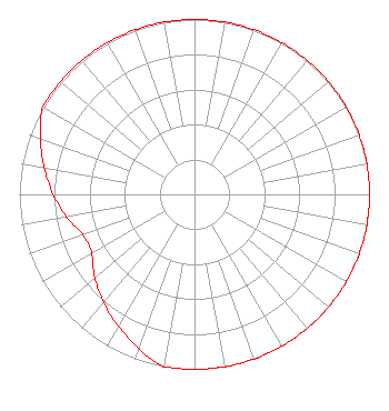 | ||||||||||||||||||
| Azimuth | Ratio | Azimuth | Ratio | Azimuth | Ratio | Azimuth | Ratio | ||||||||||||
| 0 | 1.000 | 10 | 1.000 | 20 | 1.000 | 30 | 1.000 | ||||||||||||
| 40 | 1.000 | 50 | 1.000 | 60 | 1.000 | 70 | 1.000 | ||||||||||||
| 80 | 1.000 | 90 | 1.000 | 100 | 1.000 | 110 | 1.000 | ||||||||||||
| 120 | 1.000 | 130 | 1.000 | 140 | 1.000 | 150 | 1.000 | ||||||||||||
| 160 | 1.000 | 170 | 1.000 | 180 | 1.000 | 190 | 1.000 | ||||||||||||
| 200 | 0.936 | 210 | 0.871 | 220 | 0.807 | 230 | 0.743 | ||||||||||||
| 240 | 0.678 | 250 | 0.678 | 260 | 0.743 | 270 | 0.807 | ||||||||||||
| 280 | 0.871 | 290 | 0.936 | 300 | 1.000 | 310 | 1.000 | ||||||||||||
| 320 | 1.000 | 330 | 1.000 | 340 | 1.000 | 350 | 1.000 | ||||||||||||
Structure Registration Number 1015162 [ASR Heights Differ from KJMH Application] Structure Type: TOWER Registered To: Townsquare Media Lake Charles, LLC Structure Address: 1.7 Km W Of La Hwy 101 On The N Side Of Clifton Rd Lacassine, LA County Name: Jefferson Davis Parish ASR Issued: 03/24/2021 Date Built: 08/24/1998 Site Elevation: 4.6 m (15 ft.) Structure Height: 151 m (495 ft.) Height Overall: 152 m (499 ft.) Overall Height AMSL: 156.6 m (514 ft.) FAA Determination: 07/27/1996 FAA Study #: 96-ASW-0801-OE FAA Circular #: 70/7460-1H Paint & Light FAA Chapters: 3, 4, 5, 13 30-12-08.0 N 92-56-48.0 W (NAD 83) 30-12-07.3 N 92-56-47.5 W (Converted to NAD 27) |
1 Manhattanville Road Suite 202 Purchase, NY 10577 Phone: 203-861-0900 Limited Liability Company | Date: 09/02/1998 Application Certifier PROGRESSIVE COMMUNICATIONS, INC. Holder Communications Corp. P.o. Box 3067 Lake Charles, LA 70602 Applicant | |||||||||||||||||
| |||||||||||||||||||