
FCCInfo.com
A Service of Cavell, Mertz & Associates, Inc.
(855) FCC-INFO
|
|
KNVE from 12/14/2017 KNVE from 12/04/2017 KNVE from 12/09/2015 KNVE from 10/01/2010 KNVE from 08/02/2010 KNVE from 07/15/2002 |
|
|
||||||||||||||||
|
|
KNVE Channel: 217A 91.3 MHz Redding, California Service: FM - A full-service FM station or application. Facility ID: 77093 Fac. Service: FM Analog & Digital Status: License Application Accepted: 06/20/2017 Application Granted: 06/26/2017 File Number: BLED-20170620AAK License Expires: 00/00/0000 Prefix Type: This is a license for a noncommercial educational FM station Application Type: License To Cover FCC Website Links: LMS Facility Details This Application CDBS Application Other KNVE Applications Other KNVE Applications in CDBS Including Superseded Applications Mailing Address Correspondence for KNVE Correspondence related to application BLED-20170620AAK Service Contour - Open Street Map or USGS Map (60 dBu) Service Contour - KML / Google Earth (60 dBu) Public Inspection Files Facility Type: NON-COMMERCIAL EDUC. FM Class: A, A Zone I; I-A; or II station; with 0.1kW-6kW ERP and a class contour distance <=28km Site Location: 40-39-14.9 N 122-31-15.9 W (NAD 83) Site Location: 40-39-15.4 N 122-31-11.8 W (Converted to NAD 27) Effective Radiated Power: 0.11 kW Transmitter Output Power: 0.051 kW Antenna Center HAAT: 381 m (1250 ft.) Antenna Center AMSL: 973 m (3192 ft.) Antenna Center HAG: 10 m (33 ft.) Site Elevation: 963 m. (3159 ft.) Height Overall*: 35 m (115 ft.) (* As Filed In This Application, may differ from ASR Data, Below.) Directional Antenna Antenna Make/Model: Shivley 6025-1-DA Antenna ID: 126723 Polarization: | ||||||||||||||||||
| Antenna Data for Antenna Id: 126723 KNVE FM File: BLED-20170620AAK Shivley - 6025-1-DA Service: FM | 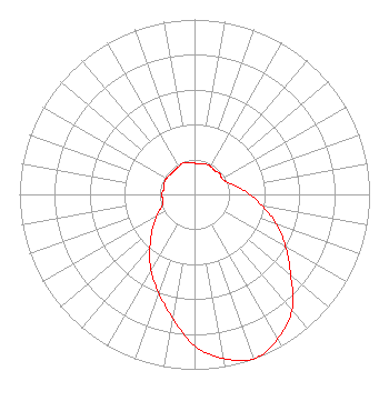 | ||||||||||||||||||
| Azimuth | Ratio | Azimuth | Ratio | Azimuth | Ratio | Azimuth | Ratio | ||||||||||||
| 0 | 0.178 | 10 | 0.178 | 20 | 0.185 | 30 | 0.185 | ||||||||||||
| 40 | 0.178 | 50 | 0.187 | 60 | 0.181 | 70 | 0.199 | ||||||||||||
| 80 | 0.250 | 90 | 0.315 | 100 | 0.396 | 110 | 0.499 | ||||||||||||
| 120 | 0.600 | 130 | 0.718 | 140 | 0.866 | 150 | 0.952 | ||||||||||||
| 160 | 1.000 | 170 | 0.952 | 180 | 0.866 | 190 | 0.718 | ||||||||||||
| 200 | 0.600 | 210 | 0.499 | 220 | 0.396 | 230 | 0.315 | ||||||||||||
| 240 | 0.250 | 250 | 0.199 | 260 | 0.181 | 270 | 0.187 | ||||||||||||
| 280 | 0.178 | 290 | 0.185 | 300 | 0.185 | 310 | 0.178 | ||||||||||||
| 320 | 0.178 | 330 | 0.182 | 340 | 0.192 | 350 | 0.182 | ||||||||||||
Structure Registration Number 1047894 [ASR Heights Differ from KNVE Application] Structure Type: 2TA2 Registered To: TARS, INC. Structure Address: Twr D - 12857 S Fork Mountain Rd Redding, CA County Name: Shasta County ASR Issued: 06/23/2004 Date Built: 10/01/1997 Site Elevation: 962.5 m (3158 ft.) Structure Height: 30.5 m (100 ft.) Height Overall: 35.4 m (116 ft.) Overall Height AMSL: 997.9 m (3274 ft.) Paint & Light FAA Chapters: None 40-39-15.0 N 122-31-16.0 W (NAD 83) 40-39-15.5 N 122-31-11.9 W (Converted to NAD 27) |
5700 West Oaks Boulevard Rocklin, CA 95765 Phone: 916-251-1600 Not-for-Profit | Date: 06/20/2017 Application Certifier EDUCATIONAL MEDIA FOUNDATION 5700 West Oaks Blvd Rocklin, CA 95765 Applicant STEPHEN WILDE 5700 West Oaks Blvd Rocklin, CA 95765 RF DESIGN ENGINEER MARY O'CONNOR Wilkinson Barker Knauer, Llp | |||||||||||||||||