
FCCInfo.com
A Service of Cavell, Mertz & Associates, Inc.
(855) FCC-INFO
|
|
WRAE from 09/25/1997 |
|  |
|
|||||||||||||||
|
|
WRAE Channel: 204C3 88.7 MHz Raeford, North Carolina Service: FM - A full-service FM station or application. Facility ID: 88446 Fac. Service: FM Status: License Application Accepted: 02/01/2011 Application Granted: 02/15/2011 File Number: BLED-20110201ADE License Expires: 00/00/0000 Prefix Type: This is a license for a noncommercial educational FM station Application Type: License To Cover FCC Website Links: LMS Facility Details This Application CDBS Application Other WRAE Applications Other WRAE Applications in CDBS Including Superseded Applications Mailing Address Correspondence for WRAE Correspondence related to application BLED-20110201ADE Service Contour - Open Street Map or USGS Map (60 dBu) Service Contour - KML / Google Earth (60 dBu) Public Inspection Files Facility Type: NON-COMMERCIAL EDUC. FM Class: C3, A Zone II station; with 6kW-25kW ERP and a class contour distance 28km-39km Site Location: 34-54-57.6 N 79-07-27.1 W (NAD 83) Site Location: 34-54-57.0 N 79-07-28.0 W (Converted to NAD 27) Effective Radiated Power: 6 kW Transmitter Output Power: 1.5 kW Antenna Center HAAT: 144 m (472 ft.) Antenna Center AMSL: 207 m (679 ft.) Antenna Center HAG: 142 m (466 ft.) Calculated Site Elevation: 65 m. (213 ft.) Height Overall*: 150 m (492 ft.) (* As Filed In This Application, may differ from ASR Data, Below.) Directional Antenna Antenna Make/Model: Shivley 6810-5-DA, five sections Antenna ID: 97103 Polarization:
| ||||||||||||||||||
| Antenna Data for Antenna Id: 97103 WRAE FM File: BLED-20110201ADE Shivley - 6810-5-DA, five sections Service: FM | 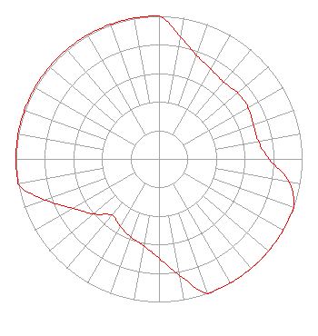 | ||||||||||||||||||
| Azimuth | Ratio | Azimuth | Ratio | Azimuth | Ratio | Azimuth | Ratio | ||||||||||||
| 0 | 1.000 | 10 | 0.867 | 20 | 0.770 | 30 | 0.725 | ||||||||||||
| 40 | 0.702 | 50 | 0.718 | 60 | 0.718 | 70 | 0.702 | ||||||||||||
| 80 | 0.704 | 90 | 0.769 | 100 | 0.923 | 110 | 1.000 | ||||||||||||
| 120 | 1.000 | 130 | 1.000 | 140 | 1.000 | 150 | 1.000 | ||||||||||||
| 160 | 1.000 | 170 | 0.827 | 180 | 0.695 | 190 | 0.617 | ||||||||||||
| 200 | 0.581 | 210 | 0.545 | 220 | 0.513 | 230 | 0.598 | ||||||||||||
| 240 | 0.692 | 250 | 0.844 | 260 | 1.000 | 270 | 1.000 | ||||||||||||
| 280 | 1.000 | 290 | 1.000 | 300 | 1.000 | 310 | 1.000 | ||||||||||||
| 320 | 1.000 | 330 | 1.000 | 340 | 1.000 | 350 | 1.000 | ||||||||||||
Structure Registration Number 1251496 Structure Type: TOWER Registered To: AMERICAN FAMILY ASSOCIATION Structure Address: 7328 St. Pauls Road Lumber Bridge, NC County Name: Hoke County ASR Issued: 10/19/2009 Date Built: 05/03/2006 Site Elevation: 65 m (213 ft.) Structure Height: 150 m (492 ft.) Height Overall: 150 m (492 ft.) Overall Height AMSL: 215 m (705 ft.) FAA Determination: 12/20/2005 FAA Study #: 2005-ASO-5493-OE FAA Circular #: 70/7460-1K Paint & Light FAA Chapters: 4, 8, 12 PRIOR STUDY 2005-ASO-1017-OE 34-54-57.5 N 79-07-27.1 W (NAD 83) 34-54-56.9 N 79-07-28.0 W (Converted to NAD 27) |
P.o. Drawer 2440 Tupelo, MS 38801-2440 Phone: 662-844-8888 Not-for-Profit | Date: 02/01/2011 Application Certifier AMERICAN FAMILY ASSOCIATION P.o. Drawer 2440 Tupelo, MS 38801 Applicant JESSICA HUCKABY P.o. Drawer 2440 Tupelo, MS 38803 TECHNICAL CONSULTANT JESSICA HUCKABY American Family Association | |||||||||||||||||