
FCCInfo.com
A Service of Cavell, Mertz & Associates, Inc.
(855) FCC-INFO
|
|
|
|
|
||||||||||||||||
|
|
W259BY Channel: 259D 99.7 MHz Waterville, Maine Service: FX - A translator or application for a translator. Facility ID: 142052 Fac. Service: FX Programming Delivery Method: Unspecified Status: License Application Accepted: 11/02/2015 Application Granted: 11/16/2015 File Number: BLFT-20151102AKI License Expires: 00/00/0000 Prefix Type: This is a license for a translator Application Type: License To Cover FCC Website Links: LMS Facility Details This Application CDBS Application Other W259BY Applications Other W259BY Applications in CDBS Including Superseded Applications Mailing Address Correspondence for W259BY Correspondence related to application BLFT-20151102AKI Service Contour - Open Street Map or USGS Map (60 dBu) Service Contour - KML / Google Earth (60 dBu) Class: D, A Noncommercial educational operating with no more than 10W Site Location: 44-29-21.2 N 69-39-05.2 W (NAD 83) Site Location: 44-29-21.0 N 69-39-07.0 W (Converted to NAD 27) Effective Radiated Power: 0.19 kW Transmitter Output Power: 0.33 kW Antenna Center HAAT: 0 m Antenna Center AMSL: 192 m (630 ft.) Antenna Center HAG: 36 m (118 ft.) Site Elevation: 156 m. (512 ft.) Height Overall*: 37 m (121 ft.) (* As Filed In This Application, may differ from ASR Data, Below.) Directional Antenna Antenna Make/Model: None Antenna ID: 122167 Polarization:
| ||||||||||||||||||
| Antenna Data for Antenna Id: 122167 W259BY FX File: BLFT-20151102AKI None - Service: FX | 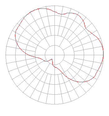 | ||||||||||||||||||
| Azimuth | Ratio | Azimuth | Ratio | Azimuth | Ratio | Azimuth | Ratio | ||||||||||||
| 0 | 0.876 | 10 | 0.836 | 20 | 0.905 | 30 | 0.939 | ||||||||||||
| 40 | 0.905 | 50 | 0.836 | 60 | 0.876 | 70 | 0.949 | ||||||||||||
| 80 | 0.987 | 90 | 0.995 | 100 | 0.970 | 110 | 0.936 | ||||||||||||
| 120 | 0.917 | 130 | 0.837 | 140 | 0.707 | 150 | 0.531 | ||||||||||||
| 160 | 0.341 | 170 | 0.268 | 180 | 0.243 | 190 | 0.205 | ||||||||||||
| 200 | 0.130 | 210 | 0.103 | 220 | 0.130 | 230 | 0.205 | ||||||||||||
| 240 | 0.243 | 250 | 0.268 | 260 | 0.341 | 270 | 0.531 | ||||||||||||
| 280 | 0.707 | 290 | 0.837 | 300 | 0.917 | 310 | 0.936 | ||||||||||||
| 320 | 0.970 | 330 | 0.995 | 340 | 0.987 | 350 | 0.949 | ||||||||||||
Structure Registration Number 1239340 [ASR Heights Differ from W259BY Application] Structure Type: LTOWER Registered To: Maine Public Broadcasting Corp Structure Address: End Of Cook Mountain Road Waterville, ME County Name: Kennebec County ASR Issued: 07/02/2019 Date Built: 09/20/2004 Site Elevation: 156 m (512 ft.) Structure Height: 33.5 m (110 ft.) Height Overall: 39.6 m (130 ft.) Overall Height AMSL: 195.6 m (642 ft.) FAA Determination: 08/31/2015 FAA Study #: 2015-ANE-1087-OE Paint & Light FAA Chapters: NONE PRIOR STUDY 2003-ANE-229-OE 44-29-21.0 N 69-39-04.8 W (NAD 83) 44-29-20.8 N 69-39-06.6 W (Converted to NAD 27) |
1450 Lisbon St Lewiston, ME 04240 Phone: 207-783-9101 | Date: 11/02/2015 Application Certifier MAINE PUBLIC BROADCASTING CORPORATION 1450 Lisbon Street Lewiston, ME 04240 Applicant BARRY S. PERSH Gray Miller Persh Llp 1200 New Hampshire Ave., N.w. Washington, DC 20036 ALEXANDER G. MAXWELL JR 63 Texas Ave Bangor, ME 04401 EMPLOYEE | |||||||||||||||||