
FCCInfo.com
A Service of Cavell, Mertz & Associates, Inc.
(855) FCC-INFO
|
|
K269EK from 10/19/1992 |
|
|
||||||||||||||||
|
|
K269EK Channel: 269D 101.7 MHz Dubuque, Iowa Service: FX - A translator or application for a translator. Facility ID: 66438 Fac. Service: FX Programming Delivery Method: Unspecified Status: License Application Accepted: 02/20/2003 Application Granted: 02/26/2003 File Number: BLFT-20030220AAB License Expires: 00/00/0000 Prefix Type: This is a license for a translator Application Type: License To Cover FCC Website Links: LMS Facility Details This Application CDBS Application Other K269EK Applications Other K269EK Applications in CDBS Including Superseded Applications Mailing Address Correspondence for K269EK Correspondence related to application BLFT-20030220AAB Service Contour - Open Street Map or USGS Map (60 dBu) Service Contour - KML / Google Earth (60 dBu) Class: D, A Noncommercial educational operating with no more than 10W Site Location: 42-31-09.0 N 90-37-11.5 W (NAD 83) Site Location: 42-31-09.0 N 90-37-11.0 W (Converted to NAD 27) Effective Radiated Power: 0.218 kW Transmitter Output Power: 0.1 kW Antenna Center HAAT: 95.5 m Horiz.; 0 m Vert. Antenna Center AMSL: 338 m (1109 ft.) Antenna Center HAG: 76 m (249 ft.) Site Elevation: 262 m. (860 ft.) Height Overall*: 255 m (837 ft.) (* As Filed In This Application, may differ from ASR Data, Below.) Directional Antenna Antenna Make/Model: None Antenna ID: 30776 Polarization:
| ||||||||||||||||||
| Antenna Data for Antenna Id: 30776 K269EK FX File: BLFT-20030220AAB None - Service: FX Pattern and Field Values Include a 270° Clockwise Rotation | 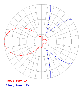 | ||||||||||||||||||
| Azimuth | Ratio | Azimuth | Ratio | Azimuth | Ratio | Azimuth | Ratio | ||||||||||||
| 0 | 0.157 | 10 | 0.130 | 20 | 0.060 | 30 | 0.027 | ||||||||||||
| 40 | 0.042 | 50 | 0.088 | 60 | 0.117 | 70 | 0.134 | ||||||||||||
| 80 | 0.143 | 90 | 0.145 | 100 | 0.143 | 110 | 0.134 | ||||||||||||
| 120 | 0.117 | 130 | 0.088 | 140 | 0.042 | 150 | 0.027 | ||||||||||||
| 160 | 0.060 | 170 | 0.130 | 180 | 0.157 | 190 | 0.141 | ||||||||||||
| 200 | 0.138 | 210 | 0.203 | 220 | 0.363 | 230 | 0.553 | ||||||||||||
| 240 | 0.727 | 250 | 0.871 | 260 | 0.966 | 270 | 1.000 | ||||||||||||
| 280 | 0.966 | 290 | 0.871 | 300 | 0.727 | 310 | 0.553 | ||||||||||||
| 320 | 0.363 | 330 | 0.203 | 340 | 0.138 | 350 | 0.141 | ||||||||||||
Structure Registration Number 1055265 Structure Type: TOWER Registered To: Second Generation Realty of Iowa Structure Address: 0.7 Mi North Of Illinois State Line, 0.7 Mi West Of Highway 35 Kieler, WI County Name: Grant County ASR Issued: 12/26/2007 Date Built: 01/01/1976 Site Elevation: 262.1 m (860 ft.) Structure Height: 240.5 m (789 ft.) Height Overall: 255.1 m (837 ft.) Overall Height AMSL: 517.2 m (1697 ft.) FAA Determination: 08/06/1998 FAA Study #: 98-AGL-3319-OE FAA Circular #: 70/7460-1J Paint & Light FAA Chapters: 3, 4, 5, 13 OM&L TO REMAIN RED LIGHTS/PAINT. 42-31-09.0 N 90-37-11.0 W (NAD 83) 42-31-09.0 N 90-37-10.5 W (Converted to NAD 27) |
2111 Grand Avenue Des Moines, IA 50312 Phone: 515-725-1705 Not-for-Profit | Date: 02/20/2003 Application Certifier THE UNIVERSITY OF IOWA 710 Clinton Street Bldg Iowa City, IA 52242 Applicant JAMES C. DAVIES 710 South Clinton Street Iowa City, IA 52242 CHIEF ENGINEER JIM DAVIES The University Of Iowa 710 Clinton Street Bldg Iowa City, IA 52242 | |||||||||||||||||