
FCCInfo.com
A Service of Cavell, Mertz & Associates, Inc.
(855) FCC-INFO
|
|
K254CM from 01/29/2016 K254CM from 09/17/2007 K254CM from 09/21/2004 |
|
|
||||||||||||||||
|
|
K254CM Channel: 254D 98.7 MHz Winona, Minnesota Service: FX - A translator or application for a translator. Facility ID: 149983 Fac. Service: FX Programming Delivery Method: Unspecified Status: License Application Accepted: 04/09/2018 Application Granted: 04/17/2018 File Number: BLFT-20180409AAL License Expires: 00/00/0000 Prefix Type: This is a license for a translator Application Type: License To Cover FCC Website Links: LMS Facility Details This Application CDBS Application Other K254CM Applications Other K254CM Applications in CDBS Including Superseded Applications Mailing Address Correspondence for K254CM Correspondence related to application BLFT-20180409AAL Service Contour - Open Street Map or USGS Map (60 dBu) Service Contour - KML / Google Earth (60 dBu) Class: D, A Noncommercial educational operating with no more than 10W Site Location: 44-02-30.9 N 91-40-47.5 W (NAD 83) Site Location: 44-02-31.0 N 91-40-47.0 W (Converted to NAD 27) Effective Radiated Power: 0.25 kW Transmitter Output Power: 0.234 kW Antenna Center HAAT: 0 m Antenna Center AMSL: 423 m (1388 ft.) Antenna Center HAG: 55 m (180 ft.) Site Elevation: 368 m. (1207 ft.) Height Overall*: 81 m (266 ft.) (* As Filed In This Application, may differ from ASR Data, Below.) Directional Antenna Antenna Make/Model: None Antenna ID: 123741 Polarization:
| ||||||||||||||||||
| Antenna Data for Antenna Id: 123741 K254CM FX File: BLFT-20180409AAL None - Service: FX Pattern and Field Values Include a 225° Clockwise Rotation | 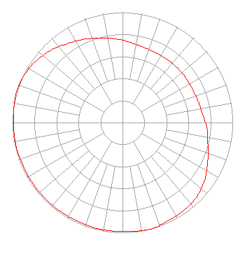 | ||||||||||||||||||
| Azimuth | Ratio | Azimuth | Ratio | Azimuth | Ratio | Azimuth | Ratio | ||||||||||||
| 5 | 0.732 | 15 | 0.710 | 25 | 0.702 | 35 | 0.702 | ||||||||||||
| 45 | 0.702 | 55 | 0.702 | 65 | 0.702 | 75 | 0.712 | ||||||||||||
| 85 | 0.732 | 95 | 0.772 | 105 | 0.802 | 115 | 0.853 | ||||||||||||
| 125 | 0.909 | 135 | 0.953 | 145 | 0.973 | 155 | 0.983 | ||||||||||||
| 165 | 1.000 | 175 | 0.992 | 185 | 0.988 | 195 | 0.988 | ||||||||||||
| 205 | 0.983 | 215 | 0.983 | 225 | 0.983 | 235 | 0.983 | ||||||||||||
| 245 | 0.983 | 255 | 0.988 | 265 | 0.988 | 275 | 0.992 | ||||||||||||
| 285 | 1.000 | 295 | 0.991 | 305 | 0.963 | 315 | 0.923 | ||||||||||||
| 325 | 0.873 | 335 | 0.832 | 345 | 0.792 | 355 | 0.762 | ||||||||||||
Structure Registration Number 1024489 Structure Type: TOWER Registered To: Leighton Radio Holdings, Inc. Structure Address: .7 Km Sw Of Hwy 61 1.4 Km Se Of Hwy 14 Winona, MN County Name: Winona County ASR Issued: 12/16/2021 Date Built: 04/01/1970 Site Elevation: 367.6 m (1206 ft.) Structure Height: 75 m (246 ft.) Height Overall: 80.8 m (265 ft.) Overall Height AMSL: 448.4 m (1471 ft.) FAA Determination: 04/07/1970 FAA Study #: 69-MSP-473-OE Paint & Light FAA Chapters: 1, 3, 11, 21 RED LIGHTS/PAINT 44-02-31.0 N 91-40-48.0 W (NAD 83) 44-02-31.1 N 91-40-47.5 W (Converted to NAD 27) |
P.o. Box 1458 St. Cloud, MN 56301 Phone: 322-511-450 | Date: 04/09/2018 Application Certifier LEIGHTON RADIO HOLDINGS, INC. P.o. Box 1458 619 West St. Germain St. St. Cloud, MN 56301-3640 Applicant CHARLES M. ANDERSON 1519 Euclid Avenue Bowling Green, KY 42103 BROADCAST CONSULTANT JOHN WELLS KING Law Office Of John Wells King, Pllc 4051 Shoal Creek Lane East Jacksonville, FL 32225-3222 | |||||||||||||||||