
FCCInfo.com
A Service of Cavell, Mertz & Associates, Inc.
(855) FCC-INFO
|
|
WGFX from 08/28/1978 WGFX from 07/21/1978 |
|  |
|
|||||||||||||||
|
|
WGFX Channel: 283C1 104.5 MHz Gallatin, Tennessee Service: FM - A full-service FM station or application. Facility ID: 16893 Fac. Service: FM Status: License 73.215 Station Application Accepted: 09/09/2002 Application Granted: 09/30/2002 File Number: BLH-20020909ABA License Expires: 00/00/0000 Prefix Type: This is a license for a commercial FM station Application Type: Amendment FCC Website Links: LMS Facility Details This Application CDBS Application Other WGFX Applications Other WGFX Applications in CDBS Including Superseded Applications Mailing Address Correspondence for WGFX Correspondence related to application BLH-20020909ABA Service Contour - Open Street Map or USGS Map (60 dBu) Service Contour - KML / Google Earth (60 dBu) Public Inspection Files History Cards for WGFX Facility Type: FM STATION Class: C1, A Zone II station; with 50kW-100kW ERP and a class contour distance 52km-72km Site Location: 36-16-05.2 N 86-47-45.0 W (NAD 83) Site Location: 36-16-05.0 N 86-47-45.0 W (Converted to NAD 27) Effective Radiated Power: 58 kW Transmitter Output Power: 36 kW Antenna Center HAAT: 368 m (1207 ft.) Antenna Center AMSL: 551.7 m (1810 ft.) Antenna Center HAG: 320 m (1050 ft.) Calculated Site Elevation: 231.7 m. (760 ft.) Height Overall*: 392.9 m (1289 ft.) (* As Filed In This Application, may differ from ASR Data, Below.) Directional Antenna Antenna Make/Model: Electronics Research Inc. 1083-3CP-DA Antenna ID: 43244 Polarization: | ||||||||||||||||||
| Antenna Data for Antenna Id: 43244 WGFX FM File: BLH-20020909ABA Electronics Research Inc. - 1083-3CP-DA Service: FM | 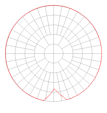 | ||||||||||||||||||
| Azimuth | Ratio | Azimuth | Ratio | Azimuth | Ratio | Azimuth | Ratio | ||||||||||||
| 0 | 1.000 | 10 | 1.000 | 20 | 1.000 | 30 | 1.000 | ||||||||||||
| 40 | 1.000 | 50 | 1.000 | 60 | 1.000 | 70 | 1.000 | ||||||||||||
| 80 | 1.000 | 90 | 1.000 | 100 | 1.000 | 110 | 1.000 | ||||||||||||
| 120 | 1.000 | 130 | 1.000 | 140 | 1.000 | 150 | 1.000 | ||||||||||||
| 160 | 1.000 | 164 | 1.000 | 168 | 0.912 | 170 | 0.871 | ||||||||||||
| 178 | 0.750 | 180 | 0.759 | 188 | 0.913 | 190 | 0.956 | ||||||||||||
| 192 | 1.000 | 200 | 1.000 | 210 | 1.000 | 220 | 1.000 | ||||||||||||
| 230 | 1.000 | 240 | 1.000 | 250 | 1.000 | 260 | 1.000 | ||||||||||||
| 270 | 1.000 | 280 | 1.000 | 290 | 1.000 | 300 | 1.000 | ||||||||||||
| 310 | 1.000 | 320 | 1.000 | 330 | 1.000 | 340 | 1.000 | ||||||||||||
| 350 | 1.000 | ||||||||||||||||||
Structure Registration Number 1233975 Structure Type: GTOWER Registered To: American Towers LLC Structure Address: Nashville, Tn Nashville, TN County Name: Davidson County ASR Issued: 05/16/2017 Date Built: 03/15/2002 Site Elevation: 231.7 m (760 ft.) Structure Height: 352.9 m (1158 ft.) Height Overall: 392.9 m (1289 ft.) Overall Height AMSL: 624.6 m (2049 ft.) FAA Study #: 02-ASO-2205-OE FAA Circular #: Paint & Light FAA Chapters: A1, B, E, H, 3, 8, 17, 21, 23 PRIOR STUDY 00-ASO-0114-OE 36-16-04.9 N 86-47-44.7 W (NAD 83) 36-16-04.7 N 86-47-44.7 W (Converted to NAD 27) |
780 Johnson Ferry Road Suite 500 Atlanta, GA 30342 Phone: 404-949-0700 Limited Liability Company | Date: 09/09/2002 Application Certifier CITADEL BROADCASTING COMPANY 7201 W. Lake Mead Boulevard Suite 400 Las Vegas, NV 89128 Applicant CAMERON ADKINS Citadel Broadcasting Company 506 2nd Avenue S. Nashville, TN 33721 MARNIE K. SARVER Wiley Rein & Fielding Llp | |||||||||||||||||
|
| ||||||||||||||||||