
FCCInfo.com
A Service of Cavell, Mertz & Associates, Inc.
(855) FCC-INFO
|
|
|
|  |
|
|||||||||||||||
|
|
WBKU Channel: 219C1 91.7 MHz Ahoskie, North Carolina Service: FM - A full-service FM station or application. Facility ID: 82838 Fac. Service: FM Status: License Application Accepted: 03/09/2017 Application Granted: 03/23/2017 File Number: BMLED-20170309AAU License Expires: 00/00/0000 Prefix Type: This is a modification of license for a noncommercial educational FM station Application Type: Minor Amendment FCC Website Links: LMS Facility Details This Application CDBS Application Other WBKU Applications Other WBKU Applications in CDBS Including Superseded Applications Mailing Address Correspondence for WBKU Correspondence related to application BMLED-20170309AAU Service Contour - Open Street Map or USGS Map (60 dBu) Service Contour - KML / Google Earth (60 dBu) Public Inspection Files Facility Type: NON-COMMERCIAL EDUC. FM Class: C1, A Zone II station; with 50kW-100kW ERP and a class contour distance 52km-72km Site Location: 36-05-45.6 N 77-12-28.9 W (NAD 83) Site Location: 36-05-45.0 N 77-12-30.0 W (Converted to NAD 27) Effective Radiated Power: 61.5 kW Transmitter Output Power: 10.5 kW Antenna Center HAAT: 131 m (430 ft.) Antenna Center AMSL: 147 m (482 ft.) Antenna Center HAG: 135 m (443 ft.) Site Elevation: 12 m. (39 ft.) Height Overall*: 150 m (492 ft.) (* As Filed In This Application, may differ from ASR Data, Below.) Directional Antenna Antenna Make/Model: Shivley 6810-8R-DA, eight sections Antenna ID: 40900 Polarization: | ||||||||||||||||||
| Antenna Data for Antenna Id: 40900 WBKU FM File: BMLED-20170309AAU Shivley - 6810-8R-DA, eight sections Service: FM | 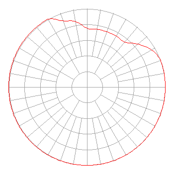 | ||||||||||||||||||
| Azimuth | Ratio | Azimuth | Ratio | Azimuth | Ratio | Azimuth | Ratio | ||||||||||||
| 0 | 0.750 | 10 | 0.750 | 20 | 0.750 | 30 | 0.750 | ||||||||||||
| 40 | 0.750 | 50 | 0.850 | 60 | 0.950 | 70 | 1.000 | ||||||||||||
| 80 | 1.000 | 90 | 1.000 | 100 | 1.000 | 110 | 1.000 | ||||||||||||
| 120 | 1.000 | 130 | 1.000 | 140 | 1.000 | 150 | 1.000 | ||||||||||||
| 160 | 1.000 | 170 | 1.000 | 180 | 1.000 | 190 | 1.000 | ||||||||||||
| 200 | 1.000 | 210 | 1.000 | 220 | 1.000 | 230 | 1.000 | ||||||||||||
| 240 | 1.000 | 250 | 1.000 | 260 | 1.000 | 270 | 1.000 | ||||||||||||
| 280 | 1.000 | 290 | 1.000 | 300 | 1.000 | 310 | 1.000 | ||||||||||||
| 320 | 1.000 | 330 | 1.000 | 340 | 0.900 | 350 | 0.850 | ||||||||||||
Structure Registration Number 1218249 Structure Type: TOWER Registered To: AMERICAN FAMILY ASSOCIATION Structure Address: Weeping Mary Road Woodville, NC County Name: Bertie County ASR Issued: 10/19/2009 Date Built: 05/13/2002 Site Elevation: 12 m (39 ft.) Structure Height: 150 m (492 ft.) Height Overall: 150 m (492 ft.) Overall Height AMSL: 162 m (531 ft.) FAA Determination: 09/20/2000 FAA Study #: 00-ASO-5835-OE FAA Circular #: 70/7460-1K Paint & Light FAA Chapters: 4, 6, 12 36-05-45.5 N 77-12-28.8 W (NAD 83) 36-05-44.9 N 77-12-29.9 W (Converted to NAD 27) |
Po Box 2440 Tupelo, MS 38803-2440 Phone: 662-844-8888 Not-for-Profit | Date: 03/09/2017 Application Certifier AMERICAN FAMILY ASSOCIATION P.o. Drawer 2440 Tupelo, MS 38803 Applicant JESSICA HUCKABY P.o. Drawer 2440 Tupelo, MS 38803 TECHNICAL CONSULTANT JESSICA HUCKABY American Family Association | |||||||||||||||||